Maps of Cambridge

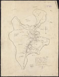
A rough and innacurate sketch of the streets of Boston as they are supposed to have been first laid out & the owners of the soil, from 1630 to 1650 or thereabouts

To His Excellency William Burnet, Esqr. This Plan of Boston in New England...
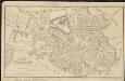
The town of Boston in New England
1 : 5600 Bonner, John, ca. 1643-1726 George G. Smith
Boston, Birthplace of the Telephone : A Pictorial Map of the Down Town Area
Chase, Ernest Dudley, 1878-1966
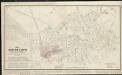
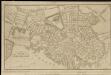
Plan of Boston comprising a part of Charlestown and Cambridge
1 : 7310 Smith, George Girdler, 1795-1878 George G. Smith
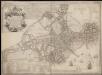
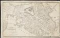
An accurate plan of the town of Boston and its vicinity : exhibiting a ground plan of all the streets, lanes, alleys, wharves, and public buildings in Boston, with the names and description thereof, likewise all the flats and channels between Boston and Charlestown, Cambridge, Roxbury & Dorchester with the two bridges and causeway, and the boundary lines beween Boston and the above mentioned towns from ...
1 : 4170 Carleton, Osgood, 1742-1816 Published and sold by Osgood Carleton
A map of the city of Boston in Massachusetts
1 : 7920 Bookshop for Boys and Girls (Boston, Mass.)
An Plan of Boston in 1722

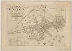
Plan of Boston showing existing ways and owners on December 25, 1645

Plan of Boston showing existing ways and owners on December 25, 1640

Plan of Boston showing existing ways and owners on December 25, 1635
A new plan of ye great town of Boston in New England in America, with the many additionall buildings & new streets to the year 1743

Boston, 1838

A new plan of Boston drawn from the best authorities with the latest improvements, additions, and corrections

Plan of Boston
1 : 9320 Edward Cotton
Plan of Boston

A new and correct plan of the town of Boston

Map of Boston proper

A plan of Boston : from an actual survey ... 1796
1 : 9320 Carleton, Osgood, 1742-1816 John West
A plan of Boston, from actual survey

Plan of Boston

Map of Boston in the state of Massachusetts
The South Cove territory, comprising every part which is coloured on this map
Plan of the city of Boston
Plan of the city of Boston
Plan of the city of Boston

Plan of Boston, 1828
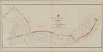
Plan showing proposed route of subway
1 : 2400 Boston (Mass.). Transit Commission L.H. Bradford & Co.'s, lith.
Boston