Maps of Zhongshan City
The Canton River

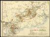
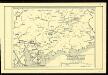
Der Sinon od. Sanon-Kreis der chinesischen Provinz Canton
Atlas der evangelischen Missions-Gesellschaft zu Basel Locher; Gross, Rudolf Im Verlag des Comptoires der evangelischen Missions-Gesellschaft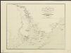
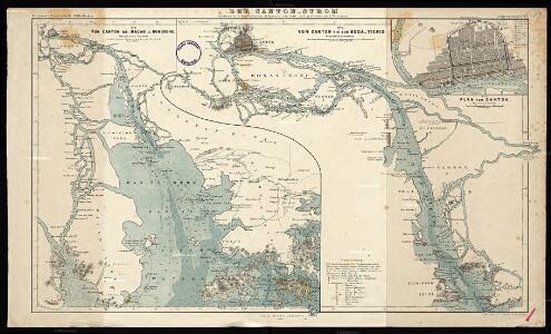
Karte des Hafens von Canton mit Macao, Whampoa, der Bocca Tigris und allen umliegenden Inseln
1 : 310000 nach der so eben in London erschienenen Karte des Herrn James Wyld gedruckt b. Rauh ; Lith. v. Geiger Wien : Verlag der Kunsthandlung H.F.M
Map of the Canton Province districts of Tunkon, Sinon and Kwuisen, including the British colony Hongkong.

Hong Kong
1 : 2500000 United States. Army Map Service. Army Map Service
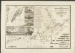
Map of the Sun-On District (Kwangtung Province)

Map of the Hongkong and Lilong mission areas.
J. Dilger
Hong Kong and the Territory Leased to Great Britain

untitled
J. Dilger
Hongkong and the New Territories

Colony of Hong Kong New Territory

Hong Kong

Kowloon and the New Territories

Kowloon and the New Territories
Collinson Map
Sketch in response to the committee minutes §1448 no. 1909
Schulze, O.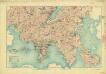
China, Kowloon and part of the new territory(1908)
China, Kowloon and part of New Territory, [G.S.G.S.] no. 2100 : reduced from a survey in 1902-1903 / by Major H.S. King R.E. Great Britain. War Office. General Staff. Geographical Section. [London] : Geographical Section, General Staff
Typa, Macao.
1 : 92000 Cook, James, 1728-1779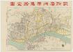
最新廣州市馬路全圖
1 : 4000 最新廣州市馬路全圖 民国十三年(1924年),广州:遠安堂 广州城市街道图。详细绘制了广州大小街道里巷并逐一标注名称,绘有广州警署12个辖区界及各分署界,同时也标注政府部门、领事馆、公园、寺庙等,但以街道信息最为详细。 1图,彩印,中文,54 x 79 cm,1:4,000 Harvard-Yenching | 3103 0832.1;Hollis Number:009268444 广州:遠安堂
De stad Macao
J. van Braam Dordrecht [Dordrecht] : J. van Braam
Atlas der evangelischen Missionsgesellschaft in Basel mit Angabe der Verbreitung der Hauptreligionen11. Der Sinon oder Sanon-Kreisder Chinesischen Provinz Canton
Chinese Province of Kwangtung
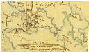
The northeastern part of the Southern Chinese Province Kwangtung (Canton) with the mission stations of the Basel, Berlin and Rhenish (Barmer) missions.
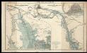
Die Chinesische Küste der Provinz Kuang-tung : zu beiden Seiten des Meridians von Macao, 2 Gr. 20 M. westlich und 1 Gr. 10 M. östlich desselben, mit Einschluss des Tschu Kiang oder Canton Stromes, von seiner Mündung aufwärts bis zur Stadt Kuang tscheu fu
1 : 420000 nach den Aufnahmen der Kapitains Daniel Ross, Horsburgh, Maughan, Newell, Auber, Blakely, &c., &c. gestochen von H. Herzberg Gotha : Perthes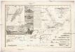
DIE CHINESISCHE KÜSTE DER Provinz Kuang-tung, zu beiden Seiten des Meridians von Macao
1 : 420000 Macao (Čína) Berghaus, Heinrich Karl Wilhelm Herzberg, H. J. Perthes
Kanton und Kantonstrom
1 : 800000 Kanton (Čína) F.A. Brockhaus' geogr.-artist. Anstalt
Chung-shan
1 : 2500000 United States. Army Map Service. Army Map Service
Ho-yüan
1 : 2500000 United States. Army Map Service. Army Map Service
Kuang-chou
1 : 2500000 United States. Army Map Service. Army Map Service