Maps of Xiangzhou District

Map of the Canton Province districts of Tunkon, Sinon and Kwuisen, including the British colony Hongkong.
Karte des Hafens von Canton mit Macao, Whampoa, der Bocca Tigris und allen umliegenden Inseln
1 : 310000 nach der so eben in London erschienenen Karte des Herrn James Wyld gedruckt b. Rauh ; Lith. v. Geiger Wien : Verlag der Kunsthandlung H.F.M
Map of the Sun-On District (Kwangtung Province)

Map of the Hongkong and Lilong mission areas.
J. Dilger
Hong Kong and the Territory Leased to Great Britain

Hongkong and the New Territories

Colony of Hong Kong New Territory

Hong Kong

Kowloon and the New Territories

Kowloon and the New Territories
Collinson Map
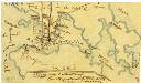
Sketch in response to the committee minutes §1448 no. 1909
Schulze, O.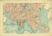
China, Kowloon and part of the new territory(1908)
China, Kowloon and part of New Territory, [G.S.G.S.] no. 2100 : reduced from a survey in 1902-1903 / by Major H.S. King R.E. Great Britain. War Office. General Staff. Geographical Section. [London] : Geographical Section, General Staff
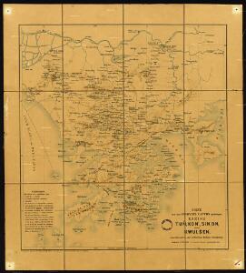
Der Sinon od. Sanon-Kreis der chinesischen Provinz Canton
Atlas der evangelischen Missions-Gesellschaft zu Basel Locher; Gross, Rudolf Im Verlag des Comptoires der evangelischen Missions-Gesellschaft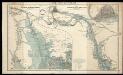
The Canton River

Atlas der evangelischen Missionsgesellschaft in Basel mit Angabe der Verbreitung der Hauptreligionen11. Der Sinon oder Sanon-Kreisder Chinesischen Provinz Canton

Hong Kong
1 : 2500000 United States. Army Map Service. Army Map Service
Chung-shan
1 : 2500000 United States. Army Map Service. Army Map Service
Chinese Province of Kwangtung
General map of the region worked on by the Basel Mission in Canton Province, China.
Lörcher, J.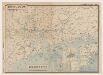
廣東香港明細地圖. 漢口南昌明細地圖
1 : 1500000 廣東香港明細地圖•漢口南昌明細地圖 昭和十三年[1938]3月1日,淵田忠良 编辑,东京:大日本雄辯會講談社 正面为《廣東香港明細地圖》,以珠三角为中心的行政图,包括香港,绘制了铁路、公路、河网和航空线,标注了县治及部分乡镇地名。附插图3幅:《汕頭附近》,为粤东地区行政区划图;《廣東》,为广州城地形简图;《香港》为维多利亚海湾两岸等高线地形图。 背面为《漢口南昌明細地圖》,西起洞庭湖,东至太湖西侧,南抵湖南、江西中部的湘潭-抚州一线,北达南京、信阳一带,以长江中游汉口-南昌-南京为中心,包括洞庭湖、鄱阳湖、巢湖等。绘制了该区域较为详细的村镇地名和交通线。 背面的汉口图较广东图详细,应与此时日军正大举进攻长江中游,并即将发动武汉会战的战争局势密切相关。 2图,黑蓝双色,日文,图幅39.5 x 54.5 cm,比例尺分别为1:820,000和1:1,500,000,无经纬线。 Harvard-YenchingManchuguo J-0886;Hollis Number:014636952 淵田忠良 大日本雄辯會講談社
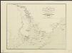
Die Chinesische Küste der Provinz Kuang-tung : zu beiden Seiten des Meridians von Macao, 2 Gr. 20 M. westlich und 1 Gr. 10 M. östlich desselben, mit Einschluss des Tschu Kiang oder Canton Stromes, von seiner Mündung aufwärts bis zur Stadt Kuang tscheu fu
1 : 420000 nach den Aufnahmen der Kapitains Daniel Ross, Horsburgh, Maughan, Newell, Auber, Blakely, &c., &c. gestochen von H. Herzberg Gotha : Perthes
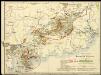
The northeastern part of the southern Chinese province Kwang Tung (Canton) with the mission stations of the Basel, Berlin and Rhenish (Barmer) Mission Societies.
DIE CHINESISCHE KÜSTE DER Provinz Kuang-tung, zu beiden Seiten des Meridians von Macao
1 : 420000 Macao (Čína) Berghaus, Heinrich Karl Wilhelm Herzberg, H. J. Perthes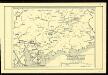
The northeastern part of the Southern Chinese Province Kwangtung (Canton) with the mission stations of the Basel, Berlin and Rhenish (Barmer) missions.

Kanton und Kantonstrom
1 : 800000 Kanton (Čína) F.A. Brockhaus' geogr.-artist. Anstalt
Ho-yüan
1 : 2500000 United States. Army Map Service. Army Map Service
Kuang-chou
1 : 2500000 United States. Army Map Service. Army Map Service
untitled
J. Dilger