Maps of Western

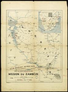
Paris Evangelical Missionary Society. Zambesi Mission.
Podrobná mapa (číslo 3.) plavby D.ra Holuba po středním toku Zambesijském od zátoky Makumbské až ku slapu Mambveskému v jižní zemi Barocké
1 : 180000 Zambezi (řeka) Holub, Emil nákladem J. Otty
Victoria Katarakt des Sebiet. Zambese
1 : 10500 Viktoriiny vodopády (Zambie a Zimbabwe) Holub, Emil
Podrobná mapa (č. 2) slapů Viktoriiných v řece Zambesi
1 : 7000 Viktoriiny vodopády (Zambie a Zimbabwe) Holub, Emil nákladem J. Otty
Jesuit mission of northern Rhodesia
1 : 1500000 Zambie Dittrich, Reinhold
Cazembes. Afrique 45.
1 : 1641836 Vandermaelen, Philippe, 1795-1869
Angola
1 : 500000 Angola jižní Ministério das colonias comissao de cartografia
172. Central Africa Mining Region. The World Atlas.
1 : 2500000 USSR (Union of Soviet Socialist Republics).
Podrobná mapa cest D.ra Holuba (čís. 1.) po střední části země východních Bamankvatův a západních Matabelův
1 : 500000 Botswana Holub, Emil nákladem J. Otty
Přehledná mapa k dílu "Sedm let v Jižní Africe" od Dra. Em. Holuba
1 : 7200000 Afrika jižní Holub, Emil J. Otta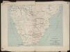
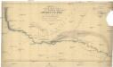
Itinéraire de Mr et Mme Coillard du Pays des Bassoutos au Zambèze
1 : 12100000 [Paris] : Société de géographie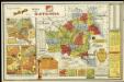
Etat du Katanga

Mozambique. Afrique 47.
1 : 1641836 Vandermaelen, Philippe, 1795-1869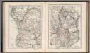
Central Africa (West). Central Africa (East).
1 : 10383000 W. & A.K. Johnston Limited
Carta de Angola
1 : 2000000 Wall Map Junta de Investigações do Ultramar Governo Geral de Angola
Carta do Sul de Angola compreendendo a regiao situada ao sul do paralello 14\00BA
1 : 500000 Angola Ministerio das Colonias, Comissao de Cartografia
Mononomatapa. Afrique 46.
1 : 1641836 Vandermaelen, Philippe, 1795-1869
Haute Luapula secteur, Katanga district, Congo State (1906)
Map showing explorations and discoveries to June 1906, [...] Haute Luapula secteur, Katanga district, Congo State, TSGS 2354. Lithogravure of the Tanganyika Concessions (Mr Geo Grey's). Shows copper and tin mines. Great Britain. General Staff. Topographical Section. [London] : [TSGS, War Office]
La Basse Guinée, contenant les royaumes de Loango, de Congo, d'Angola et de Benguela, avec la Cafrérie occidentale et la méridionale, ou le pays des Hotentots
1 : 9600000 Angola Bonne, Rigobert André
Carte des missions catholiques du centre africain
1 : 4000000 Vuillot, Paul 18..-19.. [Lyon : Oeuvre de la propagation de la foi]
Nieder-Guinea und das Innere des Westlichen Mittel-Africa's oder Westrand von Hoch-Africa
1 : 5480000 entworfen und gezeichnet von C.F. Weiland gestochen von Karl Mädel sen. Weimar : Geographisches Institut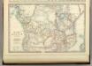
Central Africa.
1 : 10300000 Johnston, Alexander Keith
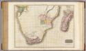
Aethiopia Inferior, vel Exterior. Partes magis Septentrionales, quae hic desiderantur, vide in tabula Aethiopiae Superioris. [Karte], in: Theatrum orbis terrarum, sive, Atlas novus, Bd. 2, S. 304.
1 Karte aus Atlas Blaeu, Joan Blaeu, Willem Janszoon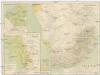
Süd-Afrika
1 : 8000000 Afrika jižní
[Afrika, Blatt 6]
Adolf Stieler's Handatlas über alle Theile der Erde und über das Weltgebäude Stieler, Adolf Justus Perthes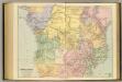
Central Africa.
1 : 5977362 Stanford, Edward
ÆTHIOPIA | INFERIOR | vel | EXTERIOR | Partes magis Septentrionales, que, | hic difiderantur, vide in tabula | Ethiopiæ Superioris.
[Amsterdam : Joan Blaeu]
Aethiopia Inferior, vel Exterior. Partes magis Septentrionales, quae hic desiderantur, vide in tabula Aethiopiae Superioris. [Karte], in: Gerardi Mercatoris et I. Hondii Newer Atlas, oder, Grosses Weltbuch, Bd. 2, S. 376.
1 Karte aus Atlas Mercator, Gerhard und Hondius, Jodocus Jansson, Jan
The "Graphic" map of south-central Africa
Afrika jižní