Maps of South Africa

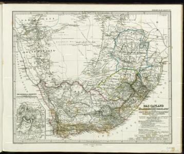
Das Capland nebst den süd-afrikanischen Freistaaten un dem Gebiet der Hottentotten & Kaffern.
A land divided against itself.A map of South Africa showing the African Homelands and some of the mass removals of people which have taken place,..
South Africa.
1 : 5000000 John Bartholomew and Son
Politisch - militärische Karte von Süd-Afrika

[Kaart], uit: Karte des Afrikander-Aufstandes im Kaplande und des Angriffskrieges der Buren / Paul Langhans
1 : 4000000 titelvariant: Karte des Afrikander-Aufstandes im Kaplande; Annotatie: Omslagtitel: Karte des Afrikander-Aufstandes im Kaplande; Met portret van Christian de Wet Langhans, Paul Gotha : Perthes
[LL.04752gk: 591/od/1899] [Recto], uit: Kaart van Zuid-Afrika : (Zuid-Afrikaansche Republiek, Oranje-Vrijstaat en aangrenzend gebied)
1 : 5600000 Amsterdam [etc.] : J.H. de Bussy
South Africa.
1 : 10080000 Peterson, Augusts
Karte des Afrikander-Aufstandes im Kaplande und des Angriffskrieges der Buren
1 : 4000000 Langhans, Paul Perthes
Karte von Transvaal und der angrenzenden Gebiete
1 : 5000000 Afrika jižní Dietrich Reimer (Ernst Vohsen)
[LL.04716gk: 591/od/1899], uit: Kaart van Zuid-Afrika : (Zuid-Afrikaansche Republiek, Oranje-Vrijstaat en aangrenzend gebied)
1 : 5600000 Amsterdam [etc.] : J.H. de Bussy
South Africa.
1 : 3817440 Johnston, W. & A.K.
[LL.04751gk: 591/od/1899] [Recto], uit: Kaart van Zuid-Afrika : (Zuid-Afrikaansche Republiek, Oranje-Vrijstaat en aangrenzend gebied)
1 : 5600000 Amsterdam [etc.] : J.H. de Bussy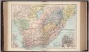
South Africa 40
1 : 4200000 Appleton, D. & Co.
Politisch-militärische Karte von Süd-Afrika : zur Veranschaulichung der Kämpfe zwischen Buren und Engländern bis zur Gegenwart / Paul Langhans
1 : 4000000 Langhans, Paul Gotha : Justus Perthes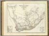
Sud. v. Africa.
1 : 3000000 Weiland, C. F. (Carl Ferdinand), d. 1847
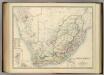
Union of South Afrika
South Africa.
1 : 3817440 Johnston, Alexander Keith
Das Capland nebst den Süd-Afrikanischen Freistaaten und dem Gebiet der Hottentotten & Kaffern
Handatlas über alle Theile der Erde und über das Weltgebäude Stieler, Adolf Justus Perthes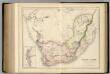
South Africa.
1 : 4118400 Fullarton, A. & Co.
[Süd-Afrika]
Hand-Atlas über alle Theile der Erde nach dem neuesten Zustande und über das Weltgebäude Stieler, Adolf bei Justus Perthes
Süd-Afrika
Hand-Atlas über alle Theile der Erde nach dem neuesten Zustande und über das Weltgebäude Stieler, Adolf bei Justus Perthes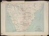
Itinéraire de Mr et Mme Coillard du Pays des Bassoutos au Zambèze
1 : 12100000 [Paris] : Société de géographie
Das Capland Nebst Den Sud-Afrikanischen Freistaaten.
1 : 5000000 Petermann, A.
Mission map of South Africa according to the map in Stieler's Atlas

Zuid-Afrika
1 : 10000000 steendruk van P.W.M. Trap [Amsterdam] : [s.n.]
Das Capland nebst den Süd-Afrikanischen Freistaaten und dem Gebiet der Hottentotten & Kaffern
Hand-Atlas über alle Theile der Erde und über das Weltgebäude Stieler, Adolf Justus Perthes
Topographical map of the Union of South Africa = Topografiese kaart van die Unie van Suid-Afrika / A.D. Lewis ; comp. in the Office of the Director of Irrigation
1 : 1500000 titelvariant: Topografiese kaart van die Unie van Suid-Afrika Lewis, A. D.; Office of the Director of Irrigation, Zuid-Afrika Pretoria : Government Printer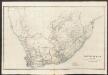
South Africa
A new general atlas of modern geography, consisting of a complete collection of maps of the four quarters of the globe Wyld, James James Wyld
Kaart van Zuid-Afrika / naar de laatste en beste bronnen bewerkt voor 'De worstelstrijd der Transvalers' door F. Lion Cachet, derde herziene druk ; A.J. Wendel grav
1 : 3000000 Annotatie geografische gegevens: Met schaalstok; Legenda Abraham Jacobus Wendel 1826-1915 Pretoria [etc.] : Boekhandel voorheen Höveker & Wormser / ([Leiden : P.W.M. Trap])