Compara
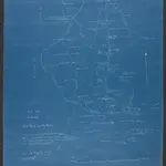
'Rough Sketch to Illustrate Road Reports and New Boundary'. '(Sgd.) M. Fowke. Capt. 4th. K.A.R. 2.6.1911.'
Shows an area on the border between the south-western portion of Uganda Protectorate and Belgian Congo, indicating hydrology, settlements and roads, with brief descriptions of vegetation and topography.
The British LibraryFowke, Mansergh Cuthbert, 1882-1914, army officer, Author.
1911
1:186 000