خريطة مفهرسة
Sheets 21-22. (Cary's England, Wales, and Scotland).

المؤسسة:The David Rumsey Map Collection
العنوان الكامل:Sheets 21-22. (Cary's England, Wales, and Scotland).
مصورة:1794
تاريخ النشر:1794
الناشر:John Cary
مقياس الخريطة:1:360 000
Monvmethensis comitatvs vernacule Monmovth Shire
1646
Blaeu
New map of the county of Hereford, 3
1754
s.n.

Monmouth (Hills) - OS One-Inch Revised New Series
1894
Ordnance Survey
1:63k

Monmouth (Outline) - OS One-Inch Revised New Series
1894
Ordnance Survey
1:63k
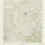
Hereford - OS One-Inch Map
1944
Ordnance Survey
1:63k

Abergavenny (Hills) - OS One-Inch Revised New Series
1894
Ordnance Survey
1:63k

Abergavenny (Outline) - OS One-Inch Revised New Series
1894
Ordnance Survey
1:63k
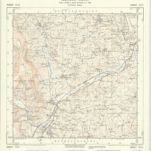
SO32 - OS 1:25,000 Provisional Series Map
1945
Ordnance Survey
1:25k
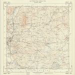
SO31 - OS 1:25,000 Provisional Series Map
1944
Ordnance Survey
1:25k
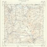
SO30 - OS 1:25,000 Provisional Series Map
1938
Ordnance Survey
1:25k