Old maps of Nord-du-Québec

Discover the past of Nord-du-Québec on historical maps

Browse the old maps

Discovering the Cartography of the Past

Nord-du-Québec


Parent places:

Related places:

City

Maps of Nord-du-Québec

Maps of Nord-du-Québec

$title$

Partie du Labrador. Amer. Sep. 28.

1 : 1641836 Vandermaelen, Philippe, 1795-1869
$title$

Partie, Nouvelle Bretagne. Amer. Sep. 35.

1 : 1641836 Vandermaelen, Philippe, 1795-1869
$title$

A new map of the province of Quebec in North America, drawn from the best authorities

1 : 6500000
$title$

188-189. Canada, East. The World Atlas.

1 : 5000000 USSR (Union of Soviet Socialist Republics).
$title$

Karten-Skizze des Treibeises bei Newfundland während der Zeit vom 11. März bis zum 5. Mai 1891, nach den Berichten, welche bis zum 20. Mai eingegangen sind

Newfoundland (Kanada : ostrov)
$title$

Karten-Skizze des Treibeises bei Newfundland während der Zeit von Anfang Mai bis Ende Juni, nach den Berichten, welche bis zum 8ten Juli eingegangen sind

Newfoundland (Kanada : ostrov)
$title$

Canada East (Lower).

1 : 1750000 Mitchell, Samuel Augustus
$title$

Canada East (Lower).

1 : 1750000 Mitchell, Samuel Augustus
$title$

Carte de la province de Quebec

1 : 3120000 Québec (Québec) Rinfret, Gustave Taché, Eugene-Étienne The Canada Eng. & Litho.
$title$

New Map Of The Province of Quebec.

1 : 2200000 Jefferys, Thomas
$title$

A Map of the British Empire in America. (Sheet 3).

1 : 2000000 Popple, Henry
$title$

A Map of the British Empire in America. (Sheet 3).

1 : 2000000 Popple, Henry
$title$

Quebec.

1 : 1850000 Rand McNally and Company
$title$

Detroit d'Hudson. Amer. Sep. 18.

1 : 1641836 Vandermaelen, Philippe, 1795-1869
$title$

A Map of the British Empire in America. (Sheet 2).

1 : 2000000 Popple, Henry
$title$

Carte de la Province de Québec, Canada ; pour accompagner la brochure intitulée "La Province de Québec et l'Émigration européenne" = Map of the province of Quebec, Canada ; to accompany the pamphlet entitled "the province of Quebec and european emigration"

1 : 2000000 Québec (province). Département des terres de la Couronne Québec : Département des terres de la Couronne
$title$

A Map of the British Empire in America. (Sheet 2).

1 : 2000000 Popple, Henry
$title$

Partie, Nouvelle Bretagne. Amer. Sep. 27.

1 : 1641836 Vandermaelen, Philippe, 1795-1869
$title$

Partie du Bas Canada. Amer. Sep. 36.

1 : 1641836 Vandermaelen, Philippe, 1795-1869
$title$

Parte Orientale del Canada, Nuova Scozia Settentrionale, e Parte di Labrador.

1 : 2100000 Zatta, Antonio
$title$

United States of America.

1 : 9504000 Carey, Mathew
$title$

An exact chart of the River St. Laurence.

1 : 695000 Jefferys, Thomas
$title$

An Exact Chart of the River St. Laurence.

1 : 695000 Jefferys, Thomas
$title$

Stratham, Rockingham Co.

1 : 26000 D.H. Hurd & Co.
$title$

New York City.

1 : 36000 Bien, Joseph Rudolf
$title$

North-eastern Canada.

1 : 5000000 John Bartholomew and Son
$title$

Geology. East sheet

1 : 6336000
$title$

Canada

1 : 10120000 Kanada Bonne, Rigobert André
$title$

North America 2.

1 : 4470000 Arrowsmith, Aaron
$title$

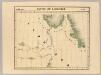
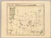
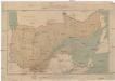
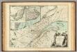
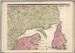
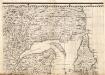
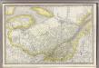
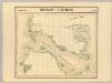
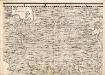
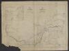
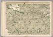
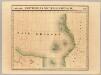
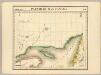
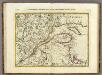
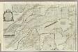
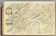
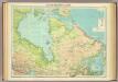
The north west part of America / by Robt. Morden.; Geography rectified, or, A description of the world: in all its kingdoms, provinces, countries, islands, cities, towns, seas, rivers, bayes, capes, ports: their antient and present names, inhabitants, situations, histories, customs, governments, &c.: as also their commodities, coins, weights, and measures, compared with those at London: illustrated with above sixty new maps: the whole work performed according to the more accurate discoveries of modern authors / by Robert Morden.

from Geography rectified, or, A description of the world : in all its kingdoms, provinces, countries, islands, cities, towns, seas, rivers, bayes, capes, ports : their antient and present names, inhabitants, situations, histories, customs, governments, &c. : as also their commodities, coins, weights, and measures, compared with those at London : illustrated with above sixty new maps : the whole work performed according to the more accurate discoveries of modern authors / by Robert Morden. Morden, Robert; Cockerill, Thomas,
© MapTiler © OpenStreetMap contributors
How does it work?
These instructions will show you how to find historical maps online.
Getting started
Type the place name in the search box to find the exact location. You can further adjust the search by zooming in and out.
Zoom
Zoom in and out with the buttons or use your mouse or touchpad natively.
Exact Area tool
Click here and draw a rectangle over the map to precisely define the search area.
Set filters
Narrow your search with advanced settings, such as Years (from/to), Fulltext, Publisher, etc.
Results
See the results of your search on the right side. You can scroll down to find more maps of this location.
?

Download OldMapsOnline Mobile