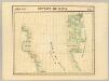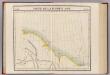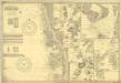
Fishing Chart. Greenland & the Davis Strait
Fishing Chart. Greenland & the Davis Strait. Compiled from the latest Danish information. Corrected to 29.11.1952. Chart no. 020. -- Insets: Approaches to Upernivik. Upernivik. Umanak. Godhavn, Jakobshavn, Holsteinsborg, Christianshaab, Holsteinsborg Havn. Approaches to Godthaabs Fjord. Disko Bay. Egedesminde Havn. Egedesminde. Sukkertoppen Havn. Approaches to Sukkertoppen. Godthaab & Skibshavn. Frederiskhaab. Frederikshaab Havn. Approach to Faeringerhavnen. Faeringerhavnen. Julianehaab. Approach to Julianehaab. Arsuk Fiord.
St. Ives, Hunts : Imray, Laurie, Norie & Wilson

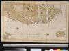
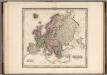
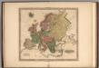
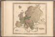
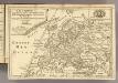
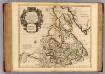
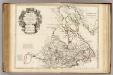
The north west part of America / by Robt. Morden.; Geography rectified, or, A description of the world: in all its kingdoms, provinces, countries, islands, cities, towns, seas, rivers, bayes, capes, ports: their antient and present names, inhabitants, situations, histories, customs, governments, &c.: as also their commodities, coins, weights, and measures, compared with those at London: illustrated with above sixty new maps: the whole work performed according to the more accurate discoveries of modern authors / by Robert Morden.
from Geography rectified, or, A description of the world : in all its kingdoms, provinces, countries, islands, cities, towns, seas, rivers, bayes, capes, ports : their antient and present names, inhabitants, situations, histories, customs, governments, &c. : as also their commodities, coins, weights, and measures, compared with those at London : illustrated with above sixty new maps : the whole work performed according to the more accurate discoveries of modern authors / by Robert Morden.
Morden, Robert; Cockerill, Thomas,
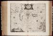
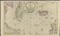
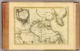
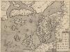
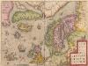
Typus Maritimus Groenlandiae, Islandiae, Freti Davidis, Insulae Iohannis Mayen, et Hitlandiae, Scotiae, et Hiberniae litora maritima Septentrionalia
1 : 7000000
Annotatie: Paskaart van de noordelijke Atlantische Oceaan met de kusten van met name het gebied tussen de Faeroër Eilanden, Groenland en Baffin Island; Origineel is Blad 149 in atlas factice; Kaart bevat diverse kompasrozen en is gedecoreerd met afbeeldingen van schepen en een walvis; Annotatie geografische gegevens: Met drie schaalstokken
[Amstelodami] : [Apud Ioannem Ianßonium]