Superior, Wisconsin / copyright ... Geo. F. Kelly.
1 : 13200
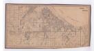
This map is mounted on cloth and shows lots and roads. An inset map is included that shows towns, lakes, rivers, and railroads within portions of the Dakota Territory, Minnesota, and Wisconsin.
Kelly, George Foster
Kelly, George Foster

Chart of harbor at Duluth, Minn. and Superior, Wisconsin / prepared under the direction of Major W.L. Fisk, Corps of Engineers, U.S. Army, in 1902-1905.
1 : 18000
This map shows streets, industrial buildings, a portion of Lake Superior and other lakes, bays, and rivers in portions of Duluth and Superior. Relief is shown by hachures; depths are shown by tints, soundings and isolines. The map is continued by an inset that shows the St. Louis River from Mud Lake to foot of rapids. Also included are notes on sailing directions, the water levels of Lake Superior, dry docks, opening and closing of navigation and abbreviations. North is oriented to the upper right. The lower left of the map reads: "Prepared under the direction of Major W.L. Fisk Corps Engineers, U.S. Army, in 1902-1905." Also noted are the dates of additions and corrections and authorities the surveys were made under.
United States. War Dept. Corps of Engineers
United States. War Dept. Corps of Engineers

Chart of harbor at Duluth, Minn. and Superior, Wis. / prepared under the direction of Major W.L. Fisk, Corps of Engineers, U.S.A.
1 : 18000
This map shows streets, industrial buildings, a portion of Lake Superior and other lakes, bays, and rivers in portions of Duluth and Superior. Relief is shown by hachures; depths are shown by tints, soundings and isolines. The map is continued by an inset that shows the St. Louis River from Mud Lake to foot of rapids. Also included are notes on the water levels of Lake Superior, dry docks at West Superior, opening and closing of navigation and abbreviations of lights and buoys. North is oriented to the upper right. The lower left of the map reads: "Prepared under the direction of Major W.L. Fisk Corps Engineers, U.S.A, from surveys made under the direction of Major Clinton B. Sears, Corps of Engineers, U.S.A., in 1901."
United States. Army. Corps of Engineers
United States. Army. Corps of Engineers

Chart of Harbor at Duluth, Minn. and Superior, Wisconsin / prepared and first issued under the directions of Colonel J.C. Sanford, and Lieut. Colonel Mason M. Patrick, Corps of Engineers, U.S. Army, in 1914-1915. , Second ed. / rev. and published under the direction of F.G. Ray.
1 : 24000
This map shows details of the harbor, proposed route and bridge changes, railroads, streets, selected buildings, a portion of Lake Superior and other lakes, bays, and rivers in portions of Duluth and Superior. Depths are shown by soundings, contours, and tints. Also included are notes on sailing directions, the water levels of Lake Superior, dry docks, opening and closing of navigation, abbreviations, and uncompleted sketches of McDougall-Duluth Ship Yard piers and Zenith Furnace Co’s pier. The left margin of the map reads:"Issued May 27, 1919 (1200)."
United States. War Dept. Corps of Engineers
United States. War Dept. Corps of Engineers


