خريطة مفهرسة
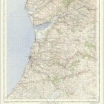
Cardiganshire XXI.SE - OS Six-Inch Map


المؤسسة:National Library of Scotland
العنوان الكامل:Cardiganshire XXI.SE - OS Six-Inch Map
مصورة:1904
تاريخ النشر:1906
الناشر:Ordnance Survey
مقياس الخريطة:1:10 560
An accurate map of Cardigan Shire
1754
Kitchin; Tinney
Ceretica; sive Cardiganensis comitatus; anglis Cardigan Shire
1646
Blaeu
Aberystwyth - OS One-Inch Map
1952
Ordnance Survey
1:63k

Aberaeron (Hills) - OS One-Inch Revised New Series
1897
Ordnance Survey
1:63k

Aberaeron (Outline) - OS One-Inch Revised New Series
1897
Ordnance Survey
1:63k

Llangranog (Hills) - OS One-Inch Revised New Series
1897
Ordnance Survey
1:63k

Llangranog (Outline) - OS One-Inch Revised New Series
1897
Ordnance Survey
1:63k

Llanilar (Hills) - OS One-Inch Revised New Series
1897
Ordnance Survey
1:63k

Llanilar (Outline) - OS One-Inch Revised New Series
1897
Ordnance Survey
1:63k

Lampeter (Hills) - OS One-Inch Revised New Series
1897
Ordnance Survey
1:63k