Cataloged map
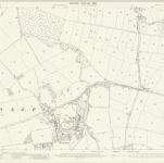
Leicestershire XXV.11 (includes: Cossington; Rothley; Syston; Thurmaston; Wanlip) - 25 Inch Map

Institution:National Library of Scotland
Full title:Leicestershire XXV.11 (includes: Cossington; Rothley; Syston; Thurmaston; Wanlip) - 25 Inch Map
Depicted:1902
Pubdate:1903
Publisher:Ordnance Survey
Map scale:1:2 500