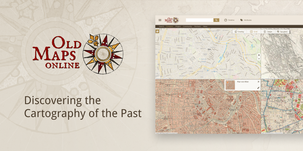
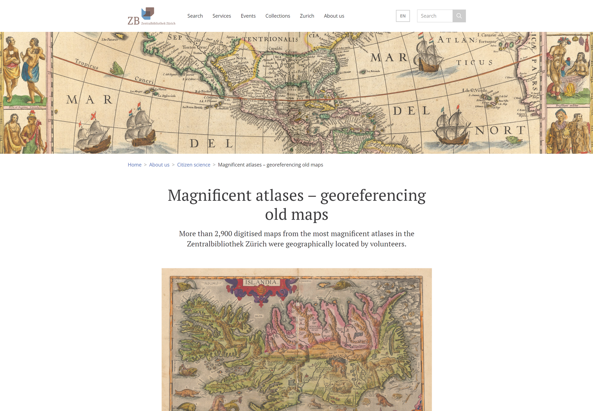
The Moravian Library in Brno, Czech Republic announces the results of the successful georeferencing contest, which was launched this year on the Staremapy.cz portal.
The crowdsourcing online event ran from July 8 to August 31 and a total of 2797 old maps were successfully georeferenced and processed by the online volunteers.
In less than two months, the participants working over the Internet from the comfort of their home identified a total of 62205 location points in the scanned maps and connected them to modern locations. This effort, among other things, made it easier, to discover the scanned old maps in the catalogues and international search databases and overlay them on top of modern maps - to compare the past with the present.
The new georeferenced maps from the Moravian Library and other domestic and foreign map collections can be found through the OldMapsOnline.org portal.
The OldMapsOnline project helps to make the historical maps more accessible to the general public. A large number of maps are stored in the collections of Czech cultural heritage institutions, which have been undergoing digitalization in recent years.
The Czech National TV broadcasted a report about this georeferencing pilot and map collection of the Moravian Library in the tv news.
Video from ceskatelevize.cz - © Copyright 2020 Ceska Televize. Reportage in czech language.
georeferencerWe are continuously and constantly enlarging the number of maps in our search engine database OldMapsOnline.org. We have recently added new historical maps and you can now search and explore maps from Utrecht University Library collections, Leiden University collections and many others. Currently, we have almost 500.000 maps listed thanks to all the participating institutions.
Please see the list of institutions that helped us.
oldmapsonlineOver 400 historical maps have been released by Technical University Darmstadt in a new Georeferencer pilot. The map collection of ULB has around 37.000 sheets from 16th to 20th century. Over 1.000 of them is scanned already and are coming back to the online life. Information about the project can be found at: http://www.ulb.tu-darmstadt.de/spezialabteilungen/kartensammlung/georeferenzierung/index.de.jsp
georeferencer | customersMap lovers will find hours and hours worth of cartographic joys on this site that draws sources from the U.S. Geological Society, the National Library of Scotland, the Land Survey Office of the Czech Republic, and many other participating institutions. Beginning as a project between Klokan Technologies GmbH, Switzerland and The Great Britain Historical GIS Project, OldMapsOnline “aims to demonstrate a combination of tools for publishing historical maps with a focus on their easy accessibility for the general public.
Full review available at: https://scout.wisc.edu/report/2015/1127#11land and The Great Britain Historical GIS Project, OldMapsOnline “aims to demonstrate a combination of tools for publishing historical maps with a focus on their easy accessibility for the general public.
oldmapsonlineIn Leiden University, over 300 of hand-drawn manuscript maps from the collection Van Keulen have been georeferenced in the new pilot. The maps were drawn between 1704-1755.
After more then 300 years it was quite tricky to place the control points, as nearly all places are using different names and on some places the landscape shape was changed significantly as well.
More information about the project available at: http://www.library.leiden.edu/special-collections/special/maps-in-the-crowd-eng.html#participate-and-win
georeferencer | customersOldMapsOnline is a search engine for maps that allows visitors to explore and discover the beauty of historical maps depicting a past geographical place of their interest. In the new version released in July 2015, additional maps have been added and the website already indexes over 400,000 scanned maps from collections of The British Library, National Library of Scotland, David Rumsey, Harvard Library, Dutch National Archives, Charles University in Prague, New York Public Library and other institutions worldwide. It is a well-known project in the cultural heritage sector. From its first launch in 2012, the website has had over 1,500,000. OldMapsOnline provides a single entry point for searching maps of the same geographical location without the need to know which library holds the actual map. This is a real benefit for researchers and students because it saves their time, effort and costs. For more information visit www.oldmapsonline.org. launch in 2012, the website has had over 1,500,000. OldMapsOnline provides a single entry point for searching maps of the same geographical location without the need to know which library holds the actual map. This is a real benefit for researchers and students because it saves their time, effort and costs. For more information visit www.oldmapsonline.org.
oldmapsonlineGlad to see another Georeferencer project for State Library New South Wales in Australia. The tricky part of this project were significant changes in names of the streets, which needed the contributors with local knowledge.
Over 900 maps were successfully placed and the obtained data enriched the library catalogue with geographical locations. More information about the project is available at http://www.sl.nsw.gov.au/using/map_georeferencing.html
georeferencer | customersWe are glad to see our IIIF Viewer applied on various websites. IIIF Viewer is an Open-Source component brought by Klokan Technologies. IIIFViewer is optimized for desktop and mobile devices (iOS, Android), is open-source, free to use and has, compared to other viewers, the following extra features:
Code is available on GitHub.
See examples of usage.
A nice example are the Maps of Scotland from the National Library of Scotland.
customers | tileserver | iiif | open-source | iipimageWe would like to give advanced notice to all our users that the infrastructure that our sites and services run on is being upgraded. This is essential maintenance and whilst it is happening Old Maps Online will be partially, and at times may be completely, unavailable.
This will occur on Saturday 17th January 2015 between 10 am and 5 pm (Central European Time).
We apologise for any inconvenience caused.
Online scans of culture heritage documents, such as old maps, books, photographs, etc. are being published by the galleries, libraries, archives and museums. Until now there was no official standardisation activity in this area. This is now changing with the International Image Interoperability Framework IIIF (http://iiif.io/), which enables easy access to large raster images across institutions.
We are happy to announce a new Open Source IIIF viewer, with several useful features:
Demo available at: http://klokantech.github.io/iiifviewer/
The viewer is pure Java Script, mobile optimised with almost native feeling for zoom and powered by OpenLayers V3 open-source project, where we are co-developers (see blog post).
Feel free to try at: http://klokantech.github.io/iiifviewer/
Source codes are available on GitHub: https://github.com/klokantech/iiifviewer/
This viewer is another important part of the mosaic of open source tools for publishing of large images and maps. Together with high-performance open-source JPEG2000 image server can be used to serve thousands of users in a very fast and efficient way.
The mentioned server providing IIIF endpoint for the JPEG2000 images was developed and released by Klokan Technologies in cooperation with the National Library of Austria and their Google Books scanning project, the Austrian Books in 2013. The documentation is available at: https://github.com/klokantech/iiifserver/ Server software runs under Linux, Mac OS X as well as Windows. There is even an easy to use installer. It is powered by IIPImage server and our code has been recently refactored and merged back to the main IIPImage repository.
Support and maintenance for installation of this open-source software can be provided by Klokan as well as the access to JPEG2000 Kakadu license.
The documentation is available at: https://github.com/klokantech/iiifserver/
osgeo | open-source | iipimageKlokan Technologies applied Georeferencer tool for Utrecht University.
There is an important issue in the Netherlands due to climate change and sea level rise problems with water retention. The University of Utrecht has an access to the collection of maps with a strong emphasis on hydrography. Part of these maps were digitized and made accessible for a large audience.
Included in mentioned collection of over 1,500 maps and atlases is also around 300 sheets of water boards, river diversions, plans for channels, dikes etc.
This collection represents important resource for landscape research and shows maps of regions, mainly Dutch. The georeferencing of the collection was realized in April 2013. With the help of this application coordinates can rather simply be added to scanned maps. Next the georeferenced maps can be consulted by means of a KML link in Google Earth or in Georeferencer’s own viewer.
Georeferencer gives archives, libraries and institutions an affordable and simple way how to engage broader public to work and become involved in attractive map collections, provides 3D visualization of maps via Google Earth and offer amazing possibility to unite past with the present.
georeferencer | customersIn these days you have the unique opportunity to get involved and help the British Library to georeference new digitized maps, which were selected for scanning and online publishing recently.
Nearly 2800 maps are now available online and waiting for georeferencing. It is really easy process.
See this video:
and start at: http://www.bl.uk/maps/ This release has implemented new functionality for use within social media, including better personalisation and visualisation options. It is possible to compare two old maps and create a personal map collection with the new “My Maps” function.
Klokan Technologies also prepared new Facebook application for georeferencing maps from the BL, you can participate and in the same moment compete with your FB friends: https://apps.facebook.com/georeferencer/
Moreover, involved contributors can choose from two different collections of maps, which were selected for release:
First collection represents maps of British and Irish towns and its fire insurance plans (2500 maps). This collection provides information, which you will not find somewhere else, not just about the land use, buildings, but also about the urban landscape in the late 19thc - 20th century.
Second collection consists of military maps from the World War I and US Civic War (225 maps). Among these maps you can find trench maps, campaign charts and also ethnographic mapping.
Each contributor will see his/her details and the best contributor will be publicly announced.
For more information, please follow this link: http://britishlibrary.typepad.co.uk/magnificentmaps/2013/11/2700-new-maps-online-for-georeferencing.html
georeferencer | customers | iipimageThe Austrian National Library scanned first 100.000 complete historical books from the beginning of 16th century until the second half of the 19th century within the project Google Books project participation. These unique historical books are now accessible online.
You can read the Press Release here:
http://www.onb.ac.at/services/presse_21764.htm
Klokan Technologies GmbH provided the Austrian National Library with the open-source IIPImage software for the display of scanned books from JPEG2000 format.
Klokan Technologies extended the mentioned open-source project with the implementation of IIIF protocol. Used protocol was defined by the consortium of people from Stanford University, Oxford University, British Library etc. (for more info please visit: http://www-sul.stanford.edu/iiif/image-api/1.1/).
The IIIF image API specifies a web service that returns an image in response to a standard http or https request.
About 600.000 copyright-free works are supposed to be digitized.
OSGeo’s Global Conference for Open Source Geospatial Software that brings together developers of map applications from all around the world. This year the conference took place in Nottingham in the UK 17th - 21st September and Klokan Technologies was there.
You can find conference’s website at: http://2013.foss4g.org/ and all presentations are available in the slideshow on YouTube: http://www.youtube.com/playlist?list=PLWW0CjV-TafaBjkroiOxcQw8NdOQ_fhu2 Anyone interested has a possibility to view the presentations from the record.
Probably the most interesting are the technical presentations about the new OpenLayers3, which is the project on which we participated and which will be used in the new version Georeferencer and StareMapy.cz.
Technical details of our work on Georeferencer and MapRank Search presented Vaclav Klusak. Afterwards, Petr Pridal spoke about the new open-source project TileServer and accessing map tiles using standard OGC WMTS.
presentations | oldmapsonline | georeferencerDespite the funding from Jisc finishing in January this year we are still working to promote the project. Petr Přidal of Klokan Technologies recently presented a poster at the International Cartographic Conference, which this year was held in Dresden, Germany from the 25th -30th August. The poster presentation focused on the Old Maps Online project as a search system tailored to work with historical maps in a spatial way, something traditional search engines struggle with, and how implementing Georeferencer as a means to turn scanned maps into digital resources which are easy to find using crowd-sourcing helped various national libraries contribute their maps to the Old Maps Online system.
Old Maps Online has been included on a list of 100 websites considered important enough to preserve for future generations. Experts from a consortium of UK national libraries chose 100 Websites which they consider will be essential reading for those looking back at 2013. An archive of these UK based websites will be created using new powers the libraries have been given to preserve digital content.
The eclectic mix of sites on the list range from social media such as facbook and ebay, via online shopping from high street stores to housing and public interest sites such as OpenStreetMap and Galaxy Zoo. Old Maps Online is described as:
"...revolutionising the way in which we conduct historical research and will be invaluable for future researchers wishing to dive through layers of history geographically"
The project team is immensely proud to have been included in this list.
Using Georeferencer software from Klokan technologies, another 800 items have been selected for the Georeferencer Project from the British Library’s collection of over 4.5 million maps. The last time the British Library undertook such a project 708 maps were completed in less than one week.
”It’s easy to use and highly addictive – and a fascinating way to explore the past while improving the information that underpins our digitised collections. This project brings together people’s passion for maps and history with the latest online crowdsourcing tools,” says Kimberly Kowal, Lead Curator of Digital Mapping at the British Library.
As a result of these previous successful rounds of public crowdsourcing, those maps are now spatially enabled, allowing users to search and navigate maps online. Maps from previous rounds are accessible through the Library’s Old Maps Online portal developed by Klokan Technologies.
georeferencer | customers | projects
After nearly a whole year of Old Maps Online being live we thought we'd do a quick review of blog comments mentioning the site which have been posted since the initial flurry of interest following the launch. Below are a selection of what we found people have said about actually using the site.
![]() |
Vienna detail from 'Viennense Territorium ob Res Bellicas inter Christianos et Turcas Nuperrime E...' by Nicolaum Visscher, [1685-1700] from the Moravian Library |
![]() |
Detail from Nairn and Elgin, W. Johnson, 1832. (c) Cartography Associates |
![]() |
Detail from Scotland SE, E. Stanford , 1901. (c) Cartography Associates |
![]() |
Name detail on the Eye Peninsula of Lewis in the Outer Hebrides from the OS of Scotland, Popular Edition, Stornoway, 1925, from A Vision of Britain through Time |