Maps of Ouargla

Schul-Atlas für die alte Erdbeschreibung : zur allgemeinen Schul-encyclopädie gehörig
J. H. Campe Zusammensetzung und Zeichnung von [...] Dufour, unter Leitung von Heusinger ; gestochen von Frentzel. Braunschweig : Schulbuchhandlung
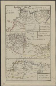
Africa propria degli antichi, Numidia, Mauritania cesariense
1 : 6000000 [Marzolla, B.] [Verlag nicht ermittelbar]
Afrique Propre.
1 : 3800000 Lapie, M. (Pierre), 1779-1850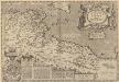
Africae Propriae Tabula, In qua, Punica regna vides; Tyrios, et Agenoris urbem. [Karte], in: Theatrum orbis terrarum, S. 523.
1 Karte aus Atlas Ortelius, Abraham Vrients, Jan Baptista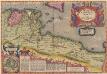
Africae Propriae Tabula, In qua, Punica regna vides; Tyrios, et Agenoris urbem. [Karte], in: Theatrum orbis terrarum, S. 439.
1 Karte aus Atlas Ortelius, Abraham
Secunda Affrice Tabula [Karte], in: [Clavdii Ptholomei Cosmographi ...], S. 290.
1 Karte aus Atlas Nicolaus Germanus [und Ptolemaeus, Claudius]
Karte von Fes und Marócos
Afrika severní Bruns, Paul Jakob Anville, Jean-Baptiste Bourguinon d' Weigel- und Schneiderschen Handlung
[Carthago; Pasitigris, Babylonia, Susiana; Africa Propria, Mauretania, Numidia]
Schul-Atlas der alten Welt bei Justus Perthes
Carte de la Régence de Tripoli et des principales routes commerciales de l'interieur de l'Afrique : d'après les observations de Mr. Prax, les renseignements recueillis par ce voyageur et les études faites par Mr. Renou
1 : 2000000 dressée par MM. Prax et Renou d'après les observations de Mr. Prax, les renseignements recueillis par ce voyageur, et les études faites par Mr. Renou gravée sur pierre par F. Delamare Paris : Lemercier
Tunis et Tripoli
Nouvel atlas physique politique et historique de l'Empire ottoman et des états limitrophes en Europe, en Asie et en Afrique, en quarante feuilles Hellert, J.J. Bellizard, Dufour et Cie
Africa 1:2.000.000, Tunisie
Tripolitania, Libya (also Tunisia)
Charte du Royaume d'Alger
1 : 3800000 Alžírsko Weiland, Karl Ferdinand Kaiser, F.
[Maroko]
Maroko Zeithammer, Antonín Otakar Badía y Leblich, Domingo
Northern Africa.
1 : 7920000 Tallis, J. & F.
Algerien (Algerie)
1 : 2450000 Ziegler, J. M.
Africa Antiqua. (1826)
1 : 6600000 Tanner, Henry S.
Afrika

[XXII], uit: Geognostische Karte des Oesterreichischen Kaiserstaates mit einem grossen Theile Deutschland's u. Italien / hauptsachlich nach ... Haidinger's geognostischer Karte dieses Staates bearb. von Josef Scheda
1 : 3000000 titelvariant: General-Karte von Europa in 25 Blättern; Annotatie: Bijlage bij: General-Karte von Europa in 25 Blättern. - 1:2.592.000. - 1845-1847 Scheda, Joseph Wien : K.K. Militär. Geografisch. Institut
An accurate map of west Barbary, including Suse & Tafilelt, forming the dominions of the present emperor of Marocco
Maroko Jackson, James Grey Neele, Samuel John G. & W. Nicoll
Carte des chemins de fer de l'Algérie et de la Tunisie
1 : 3000000 Alžírsko Chaix
Algerien (Algérie.)
Geographischer Atlas über alle Theile der Erde Ziegler, Jakob Melchior Verlag von Dietrich Reimer
Carte des divisions administratives des territoires du sud
1 : 3200000 Calléja, N.; Gouvernement général de l'Algérie
[Maroko]
Maroko Zeithammer, Antonín Otakar Badía y Leblich, Domingo
Algérie et Tunisie
1 : 2000000 Niox, Gustave-Léon 1840-1921 Paris : Ch. Delagrave
Feuille 45 (C VII), uit: Carte géologique internationale de l'Europe : la carte, votée au congrès géologique international de Bologne en 1881, est exécutée conformément aux décisions d'une commission internationale, avec le concours des gouvernements, sous le dir. de M.M. Beyrich et Hauchecorne
Annotatie: Blad 48 gamme des couleurs; blad 49: bladwijzer en titelblad Heinrich Ernst Beyrich 1815-1896; Wi. Hauchecorne Berlin : Reimer / (Berlin: Institut lithographique)
Algerien
[Allgemeiner Atlas über alle Theile der Erde in 29 Blättern] Ziegler, Jakob Melchior Top. Anstalt v. J. Wurster u. Comp.
Carte générale de l'Algérie à l'échelle de 1 m. pour 1,600,000 m
1 : 1600000 Ostblatt Duveyrier, Henri Dépôt de la Guerre
Algerien
Geographischer Atlas über alle Theile der Erde Ziegler, Jakob Melchior Verlag von Joh. Wurster um Comp.
Algérie et Tunisie : d'après les documents fournis par le Dépôt de la guerre (Service géographique) : orthographe des noms arabes d'après les principes du Général Parmentier
1 : 1800000 Paris : Lith. Lemercier & Cie.