Maps of Kommuneqarfik Sermersooq
Nieuwe platte pas kaart van de Noord Occiaan van Hitland tot in de Straat Davids seer dienstig voor de Straat Davids vaarders
1 : 3800000 welke straat nu nieulijks en naaukeurig afgeteekent en beschreeven door schipper Laurens Feykes Haan en verder in 't ligt gebragt door G. van Keulen Tot Amsterdam : bij Gerard van Keulen, boek en zee-kaart verkooper, aan de Nieuwen-brug [...]
Nieuwe afteekening van de Straat Davits van Hitland tot aen de Straet Davids
Atlantic Ocean Gerard van Keulen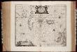
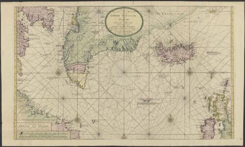
Typus Maritimus Groenlandiae, Islandiae, Freti Davidis, Insulae Iohannis Mayen, et Hitlandiae, Scotiae, et Hiberniae litora maritima Septentrionalia
1 : 7000000 Annotatie: Paskaart van de noordelijke Atlantische Oceaan met de kusten van met name het gebied tussen de Faeroër Eilanden, Groenland en Baffin Island; Origineel is Blad 149 in atlas factice; Kaart bevat diverse kompasrozen en is gedecoreerd met afbeeldingen van schepen en een walvis; Annotatie geografische gegevens: Met drie schaalstokken [Amstelodami] : [Apud Ioannem Ianßonium]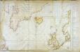
Carte réduite des mers du Nord
1 Karte : Kupferdruck ; 54 x 76 cm Verdun de la Crenne; Borda; Pingré; Petit s.n.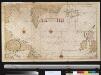
Pascaert om van Texel na de Straet Davids en Hutson te zijlen zijnde ook seer dienstig voor de gene die agterom koomen voornamentlijk voor de Westindise en Guneese schipvaert
Atlantic Ocean Gerard van Keulen
Old Greenland.
1 : 9850000 Bowen, Emanuel
Museumskart 15 Nieuwe Wassende kaart van een Gedeelte der Noorder Atlantische Oceaan
1 : 3000000 Gerard Hulst van Keulen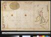
Afteekening van de Noord Occiaan strekkende van Tessel agter Irlant om tot aen de Bancq van Terra Neuf seer dienstig voor de Westindise schipvaert
Atlantic Ocean Gerard van Keulen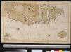
Oud Groenland van Staaten Hoek of C. Farawel tot de Visch Baij of Straet Davids int groot
Greenland Gerard van Keulen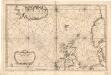
Museumskart 155: Carte Réduite De Partie De La Mer Du Nord
1 : 3000000 S. Bellin
Carte generale de toute l'Europe, 1
1 Blatt : 57 x 48 cm J.M. Will
Western part of the northern states including the British Islands Norway Denmark and part of Sweden
1 Blatt : 53 x 68 cm Sayer
Feuille 1 (A I), uit: Carte géologique internationale de l'Europe : la carte, votée au congrès géologique international de Bologne en 1881, est exécutée conformément aux décisions d'une commission internationale, avec le concours des gouvernements, sous le dir. de M.M. Beyrich et Hauchecorne
Annotatie: Blad 48 gamme des couleurs; blad 49: bladwijzer en titelblad Heinrich Ernst Beyrich 1815-1896; Wi. Hauchecorne Berlin : Reimer / (Berlin: Institut lithographique)
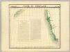
Ireland.
1 : 1950000 Bowen, Frances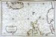
Carte réduite de partie de la mer du Nord comprise entre l'Ecosse, le Dannemark, la Norwege et l'Islande
1 Karte : Kupferdruck ; 55 x 83 cm Bellin s.n.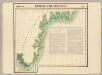
Groenland Oriental. Amer. Sep. 20.
1 : 1641836 Vandermaelen, Philippe, 1795-1869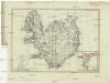
Charte von Island und den Färöer Inseln
1 : 1400000 Faerské ostrovy
CHARTE von ISLAND und den Färöer Inseln
1 : 1420000 Faerské ostrovy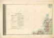
General - Karte von Europa mit Klein - Asien und dem nördlichen Afrika
Partie du Groenland. Amer. Sep. 19.
1 : 1641836 Vandermaelen, Philippe, 1795-1869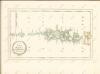

[II], uit: Geognostische Karte des Oesterreichischen Kaiserstaates mit einem grossen Theile Deutschland's u. Italien / hauptsachlich nach ... Haidinger's geognostischer Karte dieses Staates bearb. von Josef Scheda
1 : 3000000 titelvariant: General-Karte von Europa in 25 Blättern; Annotatie: Bijlage bij: General-Karte von Europa in 25 Blättern. - 1:2.592.000. - 1845-1847 Scheda, Joseph Wien : K.K. Militär. Geografisch. Institut
Feuille 9 (B II), uit: Carte géologique internationale de l'Europe : la carte, votée au congrès géologique international de Bologne en 1881, est exécutée conformément aux décisions d'une commission internationale, avec le concours des gouvernements, sous le dir. de M.M. Beyrich et Hauchecorne
Annotatie: Blad 48 gamme des couleurs; blad 49: bladwijzer en titelblad Heinrich Ernst Beyrich 1815-1896; Wi. Hauchecorne Berlin : Reimer / (Berlin: Institut lithographique)
Sheet 5 Belfast, uit: Ireland
1 : 126720 Annotatie: Enkele bladen dubbel. - Enkele bladen van een oudere uitg; De bladen 5 (1912) en 9 (1918) opgeborgen bij gevouwen kaarten. - Beide bladen met aantekeningen in rode en zwarte inkt; Annotatie geografische gegevens: Reduced from the one inch map; Met diagram van aangrenzende bladen, indexdiagram van de corresponderende bladen van de 'one inch map' en diagram van 'The National Grid' Dublin : Ordnance Survey of Ireland
Nieuwe paskaert vant Noorderdeel der Noord Zee als meede een gedeelte van de West cust van Schotlant en Irland seer dienstigh voor de kruijsers op de Oostindise scheepen
Scotland Gerard van Keulen
Feuille 16 (B III), uit: Carte géologique internationale de l'Europe : la carte, votée au congrès géologique international de Bologne en 1881, est exécutée conformément aux décisions d'une commission internationale, avec le concours des gouvernements, sous le dir. de M.M. Beyrich et Hauchecorne
Annotatie: Blad 48 gamme des couleurs; blad 49: bladwijzer en titelblad Heinrich Ernst Beyrich 1815-1896; Wi. Hauchecorne Berlin : Reimer / (Berlin: Institut lithographique)
Karten-Skizze des Treibeises bei Newfundland während der Zeit vom 11. März bis zum 5. Mai 1891, nach den Berichten, welche bis zum 20. Mai eingegangen sind
Newfoundland (Kanada : ostrov)
Karten-Skizze des Treibeises bei Newfundland während der Zeit von Anfang Mai bis Ende Juni, nach den Berichten, welche bis zum 8ten Juli eingegangen sind
Newfoundland (Kanada : ostrov)
Paskaarte om achter Yrlant om te zeylen, van Hitlant tot aen Heÿssant
1 Karte : Kupferdruck ; 43 x 54 cm Doncker by Hendrick Doncker in de Nieuwbrughsteech in 't Stuurmans gereetschap
Detroit de Davis. Amer. Sep. 10.
1 : 1641836 Vandermaelen, Philippe, 1795-1869