Maps of Ukraine
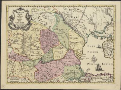
Theatrum belli ad Borysthenem, Tyram et Danubium fluvios, gesti Ao MDCCXXXVIII
1 : 2450000 excus in Academia Scientiarum Petropolitana Hagae Comitum : apud Joan. Block
Carte de la Hongrie et partie septentrionale de la Turquie
Ungarn, Osmanisches Reich L'Isle, Guillaume de
Hongrie, pays qui en dependoient autrefois.
1 : 2550000 L'Isle, Guillaume de, 1675-1726
Le Royaume De Hongrie, et les Estats qui en ont esté sujets, et qui sont preventement La Partie Septentrionale De La Tourquie En Europe [Karte], in: Atlas nouveau, contenant toutes les parties du monde [...], Bd. 2, S. 197.
1 Karte aus Atlas Sanson, Nicolas Jaillot, Alexis Hubert und Mortier, Pieter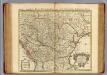
Hongrie.
1 : 2550000 L'Isle, Guillaume de, 1675-1726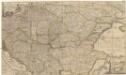
Accurate Landkarte die Königreiche Ober- und Nieder- Hungarn, Slavonien, Croatien, Dalmatien, Bosnien, Servien, Bulgarien, und Romanien, das Groß Fürstenthum Siebenbürgen, die Fürstenthümer Moldau, Wallachen, Bessarabien, die Oczakowisch- und Crimische Tartaren, die pohlnische Provinz Podolien, wie auch ein Theil von Ukranien, und übrige angränzende Ländern vorstellend
1 : 1430000 Besarábie (Moldavsko a Ukrajina) Lidl, Johann Jakob Joh. Jacob Lidl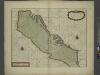
A sea chart of the Gulph of VENICE describing all the sea coasts and Islands contained therein
from The sea-atlas : containing an hydrographical description of most of the sea-coasts of the known parts of the world.
Tooneel des oorlogs aan den Dnieper, Tira en Donauw in den jare 1738 gevoerd
1 : 2500000 I. Punt del. et fecit I. en G. Kondet sculp
Galizien, Ungarn mit Slavonien und Croatien, Siebenbürgen und Dalmatien, Moldau, Wallachey
Hand-Atlas über alle Theile der Erde nach dem neuesten Zustande und über das Weltgebäude Stieler, Adolf bei Justus Perthes
Polonia Et Ungaria, XV. Nova Tabula. [Karte], in: Geographia universalis vetus et nova complectens Claudii Ptolemaei Alexandrini enarrationis libros VIII, S. 338.
1 Karte aus Atlas Münster, Sebastian [und Ptolemaeus, Claudius]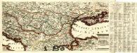
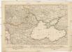
Regni Hungariae et Provinciarum adjacentium Tartariae minoris, ac Grimeae delineatio Geographica
Mollova mapová sbírka
Daciarum, Moesiarumque, Vetus Descriptio. [Karte], in: Theatrum orbis terrarum, S. 505.
1 Karte aus Atlas Ortelius, Abraham Vrients, Jan Baptista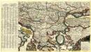
Mappa Generalis Danubii Principatum ab origine usque ejus influx um in mare nigrum
Mollova mapová sbírka Lidl, Johann Jakob
Le Royaume de Hongrie...
Tabula Europae IX. [Karte], in: Claud. Ptolemaeus. Geographia lat. cum mappis [...], S. 278.
1 Karte aus Atlas Münster, Sebastian [und Ptolemaeus, Claudius]
Le Royaume de Hongrie et des pays qui en dependoient autrefois ; Nova et accurata Regni Hungariae tabula, ad usum serenissimi Burgundiae ducis
Ungarn, Osmanisches Reich L'Isle, Guillaume de
Tabula Hungaria et regionum, quae praeterea ab ea dependent
1 : 2100000 Maďarsko Delisle, Guillaume Lotter, Georg F. T. C. Lotter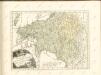
Kriegs Theater zwischen Russland und der Ottomanischen Pforte
Balkánský poloostrov Mollo, Tranquillo T. Mollo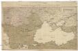
Kriegstheater oder Graenzkarte Oesterreichs, Russlands, und der Türkey
1 : 3000000 Balkánský poloostrov Schütz, C. Müller, Franz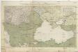
Kriegstheater oder Graenzkarte Oesterreichs, Russlands, und der Türkey
1 : 2950000 Evropa jihovýchodní Schütz, Carl Müller, Franz Artaria Compagnie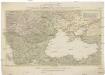
Kriegstheater oder Graenzkarte Oesterreichs, Russlands, und der Türkey
1 : 3000000 Balkánský poloostrov Schütz, C. Müller, Franz Artaria Compagnie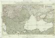
Kriegstheater oder Graenzkarte Oesterreichs, Russlands und der Türkey
1 : 3000000 Evropa jihovýchodní Schütz, C. Müller, Franz bey Artaria
Theatrum belli ad Borysthenem Tyram & Danubium fluvios
1 : 1900000 Balkánský poloostrov Academia scientiarum Petropolitana
Tabula Hungaria et regionum, quae praeterea ab ea dependent, delineata juxta magnum numerum an[n]otationum et mappas manuscriptas vel impressas
1 : 2600000 Evropa jihovýchodní Delisle, Guillaume Lotter, Georg F. Tob. Conr. Lotter
Tabula Hungaria et regionum, quae praeterea ab ea dependent, delineata juxta magnum numerum an[n]otationum et mappas manuscriptas vel impressas
1 : 2600000 Evropa jihovýchodní Delisle, Guillaume Lotter, Georg F. Tob. Conr. Lotter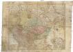
Tabula Hungaria et regionum, quae praeterea ab ea dependent, delineata juxta magnum numerum an[n]otationum et mappas manuscriptas vel impressas
1 : 2600000 Evropa jihovýchodní Delisle, Guillaume Lotter, Georg F. Tob. Conr. Lotter
Tabula Hungaria et regionum, quae praaeterea ab ea dependent, delineata juxta magnum numerum an[n]otatium et mappas manuscriptas vel impressas
1 : 2300000 Maďarsko Delisle, Guillaume Lotter, Georg F. T. C. Lotter
Tabula Hungaria et regionum, quae praaeterea ab ea dependent, delineata juxta magnum numerum an[n]otatium et mappas manuscriptas vel impressas
1 : 2300000 Maďarsko Delisle, Guillaume Lotter, Georg F. T. C. Lotter