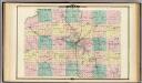
Maps of Fitchburg

Madison West
1 : 24000
Madison West
1 : 24000
Madison West
1 : 24000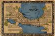
Historical map of Madison
This pictorial map focuses on the Madison Isthmus, Lake Mendota, Lake Monona, Lake Wingra, and shows points of historical interest, buildings, parks, and Indian mounds. Notes on Native American lore concerning Eagle Heights, Maple Bluff, and the Madison lakes are also featured. Kremers, Laura Colt Studio of Commercial Art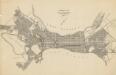
General map of city of Madison
1 : 10886 This map shows plat of the town, city limits, numbered blocks and lots, wards, local streets, roads, railroads, capitol square, Vilas Park, Edgewood Academy, the University of Wisconsin, Lake Wingra, and parts of Lake Mendota and Lake Monona. G. R. Angell & Co. G. R. Angell & Co.
Map of Madison, Wisconsin, Showing Street Plan, Location of University Grounds and Buildings, Churches, and Principle City Buildings
1 : 18185 This map shows Madison and includes an index of University of Wisconsin buildings, city buildings, and churches. Lake Mendota, Lake Monona, and Lake Wingra are labeled as well as some points of interests. The back of the map is page 11 and 14 of a University of Wisconsin directory for Philosophy and Psychology, Physical Education, Music, Pharmacy and Pharmaceutical Chemistry, and Pharmacognosy. Kruell, George John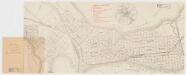
Map of Madison, Wisconsin : A.A.A.S. XLII meeting, August 17-24, 1893
1 : 20000 American Association for the Advancement of Science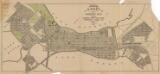
Map of Madison city : showing approaches, streets, lots, blocks, subdivisions, and general plan
1 : 6000 This map shows shows streets, subdivisions, railroads, places of interest including the State Capitol, the University of Wisconsin, Camp Randall, Henry Vilas Park, and Lakes Mendota, Monona, and Wingra. G.R. Angell and Co.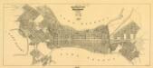
Map of the water works system of Madison, Wisconsin
1 : 10000 Shows pipes of various sizes, hydrants, valves, and wells. "1907" -- Lower margin. Lake Wingra, Lake Monona, and Lake Mendota are labelled. Pankow, Theodore John B. Heim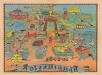
Dizzyland : Pail & Shovel Guide to the Madison Campus After Pail & Shovel Gets Its Hands On It
Map showing the University of Wisconsin-Madison re-imaged as "Dizzyland" the campus taken over the by the student government party Pail & Shovel. The map shows many campus buildings and landmarks as they may appear at a carnival, each with a new name and purpose. Many of the illustrations tie into platform pledges of the Pail & Shovel Party, an admittedly absurdist party formed primarily as a joke. The party began campaigning in the spring 1978 student elections to convert the school budget into pennies to be dumped on Library Mall where students could use pails and shovels to take what they wished. The Party also promised to flood Camp Randall Stadium for mock naval battles and buy the Statue of Liberty and move it to Wisconsin. The original is in the Edward Ben Elson papers, papers, 1960-1983, held by the Wisconsin Historical Society. Pail & Shovel Party Pail & Shovel Party
Topographic sketch map of part of U. W. campus, April 1904
1 : 720 This map is pen and pencil on paper and shows local streets, the Main Hall, South Hall, North Hall, law building, engineering building, Chadbourne Hall, Library Hall, Science Hall, and power plant. North is oriented to the right and relief is shown by contours. Ott, O. C.
Landscape plan for Floyd Place and Catlin Place, Lake Forest, Madison, Wis.
This is a collection of two maps. One map is blue line print that includes illustrations and shows the location of buildings, gardens, plant life, and springs. Inscribed on the lower right margin is: "Del. L. Fox." The other map is a blue print and survey of the subdivisions and shows streets and lots sold. The left and bottom of the map includes text written by the surveyor, Leonard S. Smith, and other witnesses and members of the Lake Forest Company, certifying that the map is a correct representation of the land surveyed. Other text is included written by the public notary and city clerk. Aust, Franz A. Lake Forest Co
Madison
1 : 62500
Madison
1 : 62500
Madison
1 : 62500
Madison
1 : 62500
Madison
1 : 62500
Madison
1 : 62500
Madison
1 : 62500
Madison
1 : 62500
Madison
1 : 62500
Madison
1 : 62500
Madison
1 : 62500
Madison
1 : 62500
Madison
1 : 62500
Madison
1 : 62500
Hydrographic map Lake Mendota.
1 : 20000 Wisconsin Geological and Natural History Survey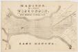
Madison : the capital of Wisconsin
s.n.
Madison and vicinity, Wisconsin, 1959
1 : 24000 Geological Survey (U.S.) The Survey