Maps of Lesser Antilles

Isla Mona
1 : 20000
Isla Mona
1 : 20000
Ins. S. Ioannis [Karte], in: Gerardi Mercatoris Atlas, sive, Cosmographicae meditationes de fabrica mundi et fabricati figura, S. 556.
1 Karte aus Atlas Mercator, Gerhard Montanus, Petrus
Porto Rico, Virgin Isles, Hispaniola.
1 : 700000 Thomson, John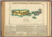
Map Of Porto Rico And The Virgin Islands.
1 : 950400 Lea, I.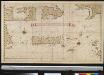
Afteekening van het eijland St. Juan de Porto Rico
Puerto Rico Gerard van Keulen
Spagnvola
1 : 1
Spagnuola
1 : 4820000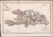
Carte de St. Domingue
1 : 1800000 Herbin de Halle, Etienne de.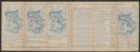
Hispaniola Insula [Karte], in: Gerardi Mercatoris Atlas, sive, Cosmographicae meditationes de fabrica mundi et fabricati figura, S. 556.
1 Karte aus Atlas Mercator, Gerhard Montanus, Petrus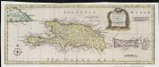
A new & accurate map of the islands of Hispaniola or St. Domingo, and Porto Rico
1 : 2750000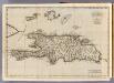
Hispaniola, St. Domingo.
1 : 1750000 Jefferys, Thomas
Karte von der durch den Frieden zu Basel den 22 July 1795 von Spanien und Frankreich abgetrettenen Insel St. Domingo oder Hispaniola
1 : 1900000 Francie Reilly, Franz Johann Josef von F.I.I. von Reilly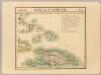
Haiti ou St. Domingue. Amer. Sep. 68.
1 : 1641836 Vandermaelen, Philippe, 1795-1869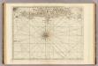
South part of St. Domingo, or Hispaniola.
1 : 1560000 Jefferys, Thomas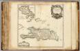
Saint Domingue ou Hispaniola, Martinique.
1 : 1700000 Robert de Vaugondy, Gilles, 1688-1766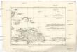
L'isle de St. Domingue, et celle de Porto-Rico
1 : 2930000 Hispaniola (ostrov) Bonne, Rigobert André
Carte des Antilles
1 : 2777775
[Puerto Rico, Kleine Antillen, Trinidad]
1 Karte : Kupferdruck ; 44 x 55 cm Doncker bij Hendrick Doncker boeckverkooper en graadbooghmaeker inde Nieuwbrugh steegh in 't Stuurmans gereedtschap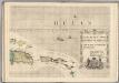
A Map of the British Empire in America. (Sheet 15).
1 : 2000000 Popple, Henry
Carte des iles Antilles. Par J.B. Poirson . Nivose An XI, 1803
1 : 3100000 Herbin de Halle, Etienne de.
Insula S.Iuan de Puerto Rico Caribes; Vel Canibalum Insulae. [Karte], in: Novus atlas absolutissimus, Bd. 9, S. 76.
1 Karte aus Atlas Janssonius Offizin
Nieuwe Carybsche Pascaart: The Carybes Ilands [Karte], in: De Nieuwe Groote Vermeerderde Zee-Atlas ofte Water-Werelt, S. 65.
1 Karte aus Atlas Doncker, Hendrick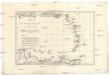
Les Petites Antilles ou les Isles du Vent avec celles de Sous le Vent
1 : 7320000 Malé Antily (souostroví) Bonne, Rigobert André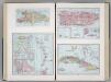
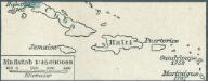
Island of Haiti. Lesser Antilles. Puerto Rico. Cuba.
1 : 3095000 Hammond, C.S.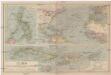
Cuba mit den benachbarten Inseln und Gebieten
1 : 6000000 Atlantský oceán Carl Flemming
Cuba, Jamaica and Puerto Rico.
1 : 2950000 Colton, G.W.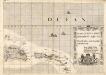
A Map of the British Empire in America. (Sheet 15).
1 : 2000000 Popple, Henry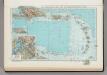
181. Haiti, Dominican Republic, Jamaica, Puerto Rico Island, Lesser Antilles, Trinidad and Tobago, Panama Canal (West Indies). The World Atlas.
1 : 3750000 USSR (Union of Soviet Socialist Republics).