Maps of Chevy Chase

Washington West
1 : 24000
Washington West
1 : 24000
Washington West
1 : 24000
Washington West
1 : 24000
Washington West
1 : 24000
Washington West
1 : 24000
Washington West
1 : 31680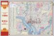
Shell Central Washington (D.C.)
Shell Oil Company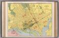
Washington D.C.
1 : 16000 Rand McNally and Company
Spot map showing residences of juvenile delinquents in the District of Columbia as of July 1, 1935
1 : 19200 [s.n.]
Base map of the District of Columbia showing railroads, main thoroughfares, alley blocks, and public (government) buildings
1 : 19000 District of Columbia. Office of the Surveyor [s.n.]
Base map of the District of Columbia showing public and zoning areas
1 : 19200 District of Columbia. Office of the Surveyor Engineer Commissioner
Topographical map of the District of Columbia and a portion of Virginia
1 : 15840 Greene, F. V. (Francis Vinton), 1850-1921 [s.n.]
Maps of the Eastern, Middle and Southern States: Washington
Map of Washington. L. Prang & Co.
Strategic War Points of the United States no.4: city of Washington and District of Columbia
Strategic War Points of the United States no.4: city of Washington and District of Columbia J. Wyld
District of Columbia
1 : 120000 Bradford, Thomas G.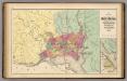
Map of the District of Columbia, Washington, Georgetown, and Alexandria.
1 : 31680 Walling, H. F.
District de Colombie.
1 : 68000 Buchon, J. A. C.; Carey, H. C.; Lea, I.
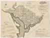
Plan of the city of Washington, in the territory of Columbia : ceded by the States of Virginia and Maryland to the United States of America, and by them established as the seat of their government after the year 1800 / J. Russell, sculpt., Constitu'n Row
from Washington, D.C.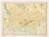
Rand, McNally & Co.'s indexed atlas of the world : map of Washington, D.C
1 : 15000 Rand McNally and Company Rand, McNally & Co.
Plan of the city of Washington, in the territory of Columbia, ceded by the States of Virginia and Maryland to the United States of America, and by them established as the seat of their government after the year 1800
1 : 19800 Russell, John
Plan of the city of Washington, now building for the metropolis of America, and established as the permanent residence of Congress after the year 1800
1 : 32800 Bent, William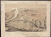
Bird's eye view of part of Maryland, Distr of Columbia and part of Virginia
Bachmann, John Rumpf, A.
Plan der stad Washington : bestemd tot de hoofdstad van America, en ter bestendige verblijfplaats van het Congres, naa het jaar 1800.
from Washington, D.C.
Washington city / I. Draper sc.
from The traveller's directory, or A pocket companion: shewing the course of the main road from Philadelphia to New York, and from Philadelphia to Washington. With descriptions of the places through which it passes ...
Plan of the city of Washington : now building for the metropolis of America, and established as the permanent residence of Congress after the year 1800 / B. Baker sculp, Islington.
from Washington, D.C.
Washington D.C.
1 : 31350 Gray, Ormando Willis
Plan of the city of Washington in the territory of Columbia : ceded by the states of Virginia and Maryland to the United States of America, and by them established as the seat of their government, after the year MDCCC
1 : 19800 Ellicott, Andrew, 1754-1820 s.n.
Colton's Georgetown and the city of Washington : the capital of the United States of America
1 : 25750 Colton, J. H. (Joseph Hutchins), 1800-1893 J.H. Colton