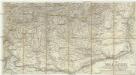
Maps of Ialomita
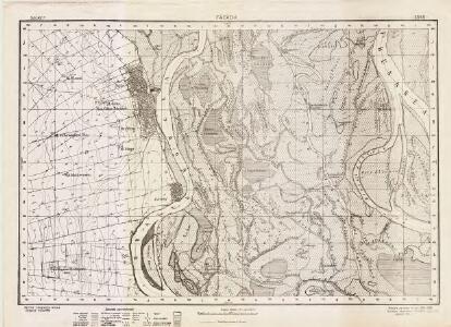
Lambert-Cholesky sheet 5245 (Făcăeni)
1 : 20000 Romanian military topographic map sheet under Lambert-Cholensky projection Direcția Topografică Militară geo-spatial.org Direcția Topografică Militară
Carte der Scharmützel zwischen den K. Truppen unter Com.do des Gr: Karaiczay und EML: Staader gegen
1 Karte : Kupferdruck ; 12 x 17 cm [Trattner]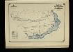
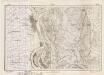
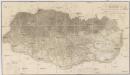
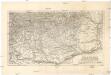
Harta Cailor de Comunicatie din Jud. Ialomita
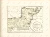
Rumänien Ialomiţa
Thracia
Mollova mapová sbírka Hoffmann, Johannes Hoffmann, Johann
Harta Cailor de Comunicatie din Jud. Constanta
Rumänien Konstanza
Dobrudscha
1 : 600000 Dobrudscha
Donau-Delta
1 : 2000000 Donaudelta
Karta na Dobrudža
1 : 750000 Rumänien Dobrudscha
Carte de la Roumanie et pays limitrophes. Galatz
1 : 500000 France. Service géographique de l'armée [Paris] : Service géographique de l'armée
Karta časti silistrijskago pašalyka meždu gorodom Bazardžikom, věkoju Kamlikom i krěpostjami Šumloju i Varnoju
1 : 700000 Pazardžik-oblast (Bulharsko)
Galati. Medgidia. Ismail. Silistra. Balcic

Galaz, Medžidie, Ismail, Silistria, Balčik
1 : 750000 Balčik (Bulharsko) Budik, Ad. K. u. k. Militärgeographisches Institut
Galaz, Medžidie, Ismail, Silistria, Balčik
1 : 750000 Balčik (Bulharsko) K. k. militär-geographisches Institut
Die Dobrudscha
Dobrudscha, Osmanisches Reich, Balkankriege Häusler, Ines
Übersichtskarte von Mittel - Europa
Die Walachei
1 : 800000 Valašsko (Rumunsko)
Carte der Besitznehmung der Wallachey von den K.K. Truppen unter Com.do des F.M. P. v. Sachsen Cobur
1 Karte : Kupferdruck ; 12 x 17 cm [Trattner]
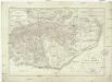
Bukuresti (Bukarest)
1 : 750000 Bukurešť (Rumunsko) Goldmann, R. K. u. k. Militärgeographisches Institut
Topographische Karte der Grossen und Kleinen Wallachey
1 : 580000 Rumunsko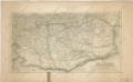
Die Walachei
Generalcharte der Walachey
1 : 740000 Rumunsko Fried, Franz Kunst und Industrie Comptoir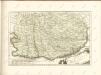
Die Walachei
1 : 800000 Valašsko (Rumunsko) Kiepert, Heinrich Hanemann, August Geographisches Institut
[Šumla]
Bulgarien Šumen Russisch-Türkischer Krieg <1806-1812>
Carte der Wallachei
1 : 1000000 Valašsko (Rumunsko) Adam, Jakob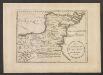
Des Koenigreichs Bulgarien Oestliche Haelfte
1 : 1200000 Bulgarien (Ost)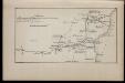
1809 god [Bukarest]
Rumänien Bukarest Russisch-Türkischer Krieg <1806-1812>
Prima pars mappae integri tractus confinium (cujus divisio correspondet cum novissima scriptura, sub dato 14. augusti[)] quae continet confinium mediatum cum Turcis, per Valachiam et Moldaviam in Transilvania ad usum tractationis pacis
1 : 295000 Rumunsko