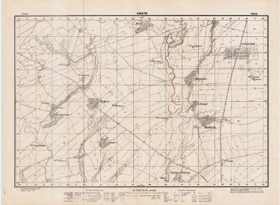
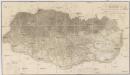
Maps of Buzau
Lambert-Cholesky sheet 4549 (Amaru)
1 : 20000 Romanian military topographic map sheet under Lambert-Cholensky projection Direcția Topografică Militară geo-spatial.org Direcția Topografică Militară
Harta cailor de comunicatie din Judetul Prahova
1 : 200000 Rumunsko Ministerul Lucrărilor Publice
Harta Cailor de Comunicatie din Judetul Buzeu
Rumänien Buzău
Grosse Walachei
1 : 600000 Große Walachei
Bucure\0219ti
1 : 400000
Karta na Dobrudža
1 : 750000 Rumänien Dobrudscha
Nagyszeben (Hermannstadt), Brassó (Kronstadt), Bukarest, Craiova, Vidin, Rusčuk
1 : 750000 Brašov (Rumunsko : oblast) Korb, L. K. u. k. Militärgeographisches Institut
Hermannstadt, Kronstadt, Bukarest, Craiova, Vidin, Rusčuk
1 : 750000 Brašov (Rumunsko : oblast) K. k. militär-geographisches Institut
Galati. Medgidia. Ismail. Silistra. Balcic

Galaz, Medžidie, Ismail, Silistria, Balčik
1 : 750000 Balčik (Bulharsko) Budik, Ad. K. u. k. Militärgeographisches Institut
Galaz, Medžidie, Ismail, Silistria, Balčik
1 : 750000 Balčik (Bulharsko) K. k. militär-geographisches Institut
Die Dobrudscha
Dobrudscha, Osmanisches Reich, Balkankriege Häusler, Ines
Übersichtskarte von Mittel - Europa
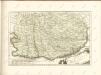
Valachia.
1 : 1400000 Mollova mapová sbírka Bruggen, Johann van der Brugge, Johannes van der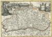
Valachia
1 : 1400000 Mollova mapová sbírka Pfeffel, Johann Andreas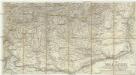
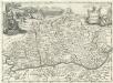
Die Walachei
1 : 800000 Valašsko (Rumunsko)
Carte der Besitznehmung der Wallachey von den K.K. Truppen unter Com.do des F.M. P. v. Sachsen Cobur
1 Karte : Kupferdruck ; 12 x 17 cm [Trattner]
Bukuresti (Bukarest)
1 : 750000 Bukurešť (Rumunsko) Goldmann, R. K. u. k. Militärgeographisches Institut
Topographische Karte der Grossen und Kleinen Wallachey
1 : 580000 Rumunsko
J.7. Bucuresti (Bukarest), uit: [Übersichtskarte von Europa 1:750.000]
1 : 750000 Wien : K.u.K. Militärgeographisches Institut
Strassen- und Eisenbahnkarte des oesterreichischen Kaiserthumes
1 : 864000 Blatt 12 Schaller, G. K.K. Militärisch-Geografisches Institut, Karten-Evidenthaltungs-Abteilung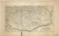
Die Walachei

Gouv. 37. Witebsk, 38. Mohilew
1 : 2300000 1 Karte : Lithographie ; 26 x 19 cm Schlieben, W.E.A. von [Georg Joachim Göschen]
Nova et accurata Turcicarum et Tartaricarum Provinciarum / excudit à Matth. Seuttero, S.C.M. Geogr
1 : 5400000 1 Karte : Kupferdruck ; 18 x 24 cm Lotter, Tobias Conrad anjezo im Verlag bey T.C. Lotter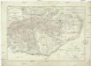
Generalcharte der Walachey
1 : 740000 Rumunsko Fried, Franz Kunst und Industrie Comptoir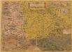
Transilvania. [Karte], in: Theatrum orbis terrarum, S. 101.
1 Karte aus Atlas Ortelius, Abraham
Gouv. 30. Kherson, 33. Bessarabien
1 : 2300000 1 Karte : Lithographie ; 22 x 26 cm Schlieben, W.E.A. von [Georg Joachim Göschen]