Maps of Pleven

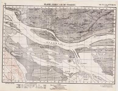
Lambert-Cholesky sheet 3735 (Ins. Belina şi Bârzina Mr.)
1 : 20000 Romanian military topographic map sheet under Lambert-Cholensky projection Serviciul Geografic al Armatei geo-spatial.org Serviciul Geografic al Armatei
Bataille de Nicopolis
Nouvel atlas physique politique et historique de l'Empire ottoman et des états limitrophes en Europe, en Asie et en Afrique, en quarante feuilles Hellert, J.J. Bellizard, Dufour et Cie
[Donauinseln bei Ruse : Russ. Militäroperation]
Bulgarien Ruse Russisch-Türkischer Krieg <1877-1878>
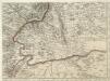
Karte von den durch die Waffen erroberten und durch den Frieden zu Szistow am 4 August 1791 von der ottomanischen Pforte an das Erzhaus Oestreich abgetrettenen Antheilen von Turkisch Kroatien und der Walachey
1 : 170000 Rumunsko Reilly, Franz Johann Josef von F. I. I. von Reilly
Karte von den durch die Waffen erroberten und durch den Frieden zu Szistow am 4 August 1791 von der ottomanischen Pforte an das Erzhaus Oestreich abgetrettenen Antheilen von Turkisch Kroatien und der Walachey
1 : 170000 Bulharsko Reilly, Franz Johann Josef von F. I. I. von Reilly
[Pleven]
1 : 800000 Bulgarien Pleven Russisch-Türkischer Krieg <1877-1878> Schlacht von Pleven
[Pleven]
1 : 800000 Bulgarien Pleven Russisch-Türkischer Krieg <1877-1878> Schlacht von Pleven
Harta Cailor de Comunicatie din Jud. Teleorman
Rumänien Teleorman
Harta cailor de comunicatie din Judetul Teleorman
1 : 200000 Rumunsko Ministerul Lucrărilor Publice
Harta Cailor de Comunicatie din Judetul Vlasca
Rumänien Vlaşca
Bulgarisch-rumänische Grenze
1 : 600000 Bulgarien, Rumänien, Grenze
Generalkarte von Zentraleuropa

XX, uit: General-Karte des oesterreichischen Kaiserstaates mit einem grossen Theile der angrenzenden Länder / durch Josef Scheda ... bearb. und hrsg
1 : 576000 Annotatie geografische gegevens: Maatstokken: oesterreichische Meilen, geografische oder deutsche Meilen, preussische Meilen, türkische Berri, französische Lieues, russische Werste; Maatstok per blad: wiener Klafter, öster. Meilen; Blad XIX: statistische en taalkundige informatie; Blad XIX: legenda [Wien : K.K. Militärisch-Geografisches Institut]
Strassen- und Eisenbahnkarte des oesterreichischen Kaiserthumes
1 : 864000 Blatt 16 Schaller, G. K.K. Militärisch-Geografisches Institut, Karten-Evidenthaltungs-Abteilung
[Jižní Rumunsko]
Rumunsko
Bulgaria
Mollova mapová sbírka Hoffmann, Johannes Hoffmann, Johann
Sheet XX: Karte Des Oesterreichischen Kaiserstaates.
1 : 576000 Scheda, Josef
Carte de la Roumanie et pays limitrophes. Bukarest
1 : 500000 France. Service géographique de l'armée [Paris] : Service géographique de l'armée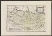
Des Koenigreichs Bulgarien Westliche Hälfte
1 : 1200000 Bulgarien (West)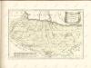

Nagyszeben (Hermannstadt), Brassó (Kronstadt), Bukarest, Craiova, Vidin, Rusčuk
1 : 750000 Brašov (Rumunsko : oblast) Korb, L. K. u. k. Militärgeographisches Institut
Hermannstadt, Kronstadt, Bukarest, Craiova, Vidin, Rusčuk
1 : 750000 Brašov (Rumunsko : oblast) K. k. militär-geographisches Institut
Übersichtskarte von Mittel - Europa
Augustissimo Romanor. Imperatori Iosepho I. Hungaria Regi Invictissimo Mappam Hanc Regni Hungariae
1 : 540000 Mollova mapová sbírka Müller, Johann Christoph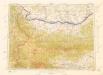
Letecká mapa Evropy
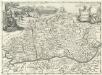
Valachia.
1 : 1400000 Mollova mapová sbírka Bruggen, Johann van der Brugge, Johannes van der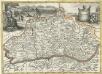
Valachia
1 : 1400000 Mollova mapová sbírka Pfeffel, Johann Andreas
Carte der Besitznehmung der Wallachey von den K.K. Truppen unter Com.do des F.M. P. v. Sachsen Cobur
1 Karte : Kupferdruck ; 12 x 17 cm [Trattner]
Bukuresti (Bukarest)
1 : 750000 Bukurešť (Rumunsko) Goldmann, R. K. u. k. Militärgeographisches Institut