Maps of Odessa
Gouv. 22. Orel, 23. Kursk, 26. Tschernigow
1 : 2300000 1 Karte : Lithographie ; 19 x 27 cm Schlieben, W.E.A. von [Georg Joachim Göschen]
Gouv. 6. Moskwa, 7. Smolensk, 21. Kaluga
1 : 2200000 1 Karte : Lithographie ; 19 x 26 cm Schlieben, W.E.A. von [Georg Joachim Göschen]
Gouv. 12. Archangelsk
1 : 5800000 1 Karte : Lithographie ; 27 x 19 cm Schlieben, W.E.A. von [Georg Joachim Göschen]
Gouv. 31 Taurien, 31a Das Land der Tschernomorskischen Kosaken
1 : 2300000 1 Karte : Lithographie ; 19 x 29 cm Schlieben, W.E.A. von [Georg Joachim Göschen]
Von dem Landt Armenia dem groessern
1 : 3800000 1 Karte : Holzschnitt ; 24 x 16 cm Münster, Sebastian [Henricpetri]
Sarmatia Asie
1 : 3800000 1 Karte : Holzschnitt ; 24 x 16 cm Münster, Sebastian [Henricpetri]
Sarmatia Asie
1 : 3800000 1 Karte : Holzschnitt ; 24 x 16 cm Münster, Sebastian [Henricpetri]
Sarmatia Asie
1 : 3800000 1 Karte : Holzschnitt ; 24 x 16 cm Münster, Sebastian [Henricpetri]
Nouveau plan routier de la ville de St.Pétersbourg
1 : 20000 1 Karte : Kupferdruck ; 27 x 36 cm [A. Pluchart]
Rvssiæ, vulgo Moscovia, pars australis / auctore Isaaco Massa
1 : 3910000 1 Karte : Kupferdruck ; 38 x 51 cm Massa, Isaac Abrahamsz Apud Johan et Cornelium Blaeu
Gouv. 29. Jekatarinoslaw
1 : 2300000 1 Karte : Lithographie ; 19 x 26 cm Schlieben, W.E.A. von [Georg Joachim Göschen]
Gouv. 9. Twer, 14. Jaroslaw
1 : 2200000 1 Karte : Lithographie ; 19 x 26 cm Schlieben, W.E.A. von [Georg Joachim Göschen]
Partie meridionale de la Russie européenne, Tartarie russienne et petite Tartarie / Par le Sr. Robe
1 : 7500000 1 Karte : Kupferdruck ; 23 x 29 cm Dussy, E. [Delamarche]
Accurata Delineatio Sinus Finnici Cronstadio Petropolin usque, una cum locis amoenis in litore ejus
1 : 70000 1 Karte : Kupferdruck ; 49 x 56 cm Seutter, Matthäus [Matthäus Seutter]
Carte de la Moscovie meridionale
1 : 7900000 1 Karte : Kupferdruck ; 17 x 26 cm L'Isle, Guillaume de Chez Paul de la Feuille
Gouv. 10. Nowogorod, 11. Olonez
1 : 3600000 1 Karte : Lithographie ; 27 x 19 cm Schlieben, W.E.A. von [Georg Joachim Göschen]
Podolia et Bessarabia.
1 : 2200000 Mollova mapová sbírka Bruggen, Johann van der Brugge, Johannes van der
Moldavia
1 : 2200000 Mollova mapová sbírka Pfeffel, Johann Andreas
Carte de la Roumanie et pays limitrophes. Balta
1 : 500000 France. Service géographique de l'armée [Paris] : Service géographique de l'armée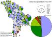
Stadtbevölkerung in der Republik Moldau 1989
Moldawien Stadtbevölkerung Hofinger, Veronika
Übersichtskarte von Mittel - Europa

Übersichtskarte von Mittel - Europa

Republik Moldau 1989. Ethnische Zusammensetzung der Bevölkerung - Moldauer (Rumänen)
Moldawien ethnische Gruppe, Moldauer Hofinger, Veronika
Republik Moldau 1989. Ethnische Zusammensetzung der Bevölkerung - Ukrainer
Moldawien ethnische Gruppe, Ukrainer Hofinger, Veronika
Bielcy, Kisziniew, Jassi
1 : 750000 Jasy (Rumunsko) Czerny, Eduard K. u. k. Militärgeographisches Institut
Bielcy, Kisziniew, Jassi
1 : 750000 Jasy (Rumunsko) K. k. militär-geographisches Institut
Kʺ pochodu 1711 goda.
Moldawien Nordischer Krieg <1700-1721>
Trigonometrisk grunnlag, vedlegg 65, 2-5: Grunnlagspunkter for Struves meridianbue fra Bessarabia og Volhynia
1 : 200000 de Tenner
Gouv. 25. Kiew, 27. Pultawa
1 : 2200000 1 Karte : Lithographie ; 19 x 27 cm Schlieben, W.E.A. von [Georg Joachim Göschen]