Maps of Tekirdağ

[Romanien]
1 Karte : Kupferdruck ; 18 x 13 cm
Die Dardanellen in ihrer Lage zu Konstantinopel
Dardanellen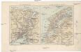
Bosporus, Dardanellen
Bospor (Turecko : průliv) F. A. Brouckaus' Geogr.-artist. Anstalt
Charte von der Strasse der Dardanellen oder Hellespont und dem Canal Constantinopel (Bosporus) nebst dem Meer von Marmora mit den anliegenden Gegend von Europa und Asia
1 : 540000 Bospor (Turecko : průliv) Güssefeld, Franz L. Faden, W. A.G. Schneider u. Weigel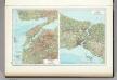
148. Dardanelles. Bosporus. The World Atlas.
1 : 500000 USSR (Union of Soviet Socialist Republics).
Übersichtskarte
1 : 400000 Türkei Osmanisches Reich Balkankrieg <1912-1913> Mahmud, Muhtar Paşa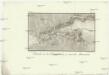
Estrecho de los Dardaneles, y mar de Mármara
Dardanely (Turecko : průliv) Velazques, J. Brieva, S.
Prolyv Dardanel'skīj i plan sraženīja maīja 10 1807
Türkei Seeschlacht Dardanellen
Generalkarte von Zentraleuropa

Kriegslage bei der Ostarmee am 29. Oktober 1912 Morgens
Türkei Osmanisches Reich Kırklareli Balkankrieg <1912-1913> Mahmud, Muhtar Paşa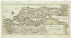
Helespont ou Detroit des Dardanelles
1 : 100000 Dardanely (Turecko : průliv) Maire, Francois Joseph
Der Hellespont
1 : 592000 Dardanely (Turecko : průliv) Barbié du Bocage, Jean Denis Anville, Jean-Baptiste Bourguinon d'
Die Dardanellen oder Hellenspont
1 : 460000 Dardanely (Turecko : průliv)
Canal des Dardanelles
Nouvel atlas physique politique et historique de l'Empire ottoman et des états limitrophes en Europe, en Asie et en Afrique, en quarante feuilles Hellert, J.J. Bellizard, Dufour et Cie
Die Dardanellen
1 : 300000 Dardanellen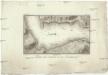
Plano del contorno de los Dardaneles
Dardanely (Turecko : průliv) Velazques, J. Vazques, J.
Gefechte bei Erikler und Petra am 22. Oktober 1912
Türkei Osmanisches Reich Kırklareli Balkankrieg <1912-1913> Mahmud, Muhtar Paşa
Kriegslage auf dem rechten Flügel am Nachmittage des 29. Oktober 1912
Türkei Osmanisches Reich Kırklareli Balkankrieg <1912-1913> Mahmud, Muhtar Paşa
Artillerie-Aufstellung und Ziele am 30. Oktober 1912 am Karaaghatsch dere
Türkei Osmanisches Reich Kırklareli Balkankrieg <1912-1913> Mahmud, Muhtar Paşa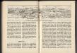
Panorama von Adrianopel
Türkei Osmanisches Reich Edirne Panorama
Gallipoli Peninsula (1915)
[A collection of military maps of the Gallipoli Peninsula] / [G.H.Q. M.E.F.]. Great Britain. Army. Middle East Force. General Headquarters. [Cairo] : G.H.Q. M.E.F.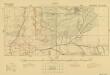
Trench maps of Suvla (provisional) 1:10 000 series (Square 105)
[Trench maps of Suvla (provisional) 1:10 000 series]. Great Britain. Army. Middle East Force. [S.l.] : G.H.Q. M.E.F.
Zum Nachtgefecht bei Karagatsch 16. Jänner 1878
1 : 16000 Edirne (Turecko : oblast)
Gelände des Erkundungsrittes, auf dem der Verfasser verwundet wurde
Türkei Osmanisches Reich Balkankrieg <1912-1913> Mahmud, Muhtar Paşa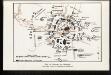
Plan der Belagerung Adrianopel
Türkei Osmanisches Reich Edirne Balkankrieg <1912-1913>
Rechter Flügel der Tschataldja-Linie
1 : 105000 Türkei Osmanisches Reich Balkankrieg <1912-1913> Çatalca Çatalca / Schlacht
Der Dardanellen Fortsetzung zum Marmarameer und Nord-Gallipoli
Dardanellen, Halbinsel Gelibolu
[Dardanellen]
Dardanellen Weltkrieg <1914-1918>
Constantinople & surrounding country Scale, 1 : 63,360, etc
Sheet 3 of the four-sheet series, Constantinople & surrounding country. Scale, 1 : 63,360, etc. [London] : Geographical Section, General Staff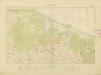
![[Romanien]](https://images-2.georeferencer.com/images/iiif/775929804490/full/,300/0/native.jpg)

