Maps of Central Macedonia Region

[Macedonien]
1 Karte : Kupferdruck ; 18 x 13 cm [Trattner]
[Mazedonien]
Makedonien
Demarkationslinie vor Beginn der Kriege gegen die Bulgaren
Südosteuropa Balkankrieg <1912-1913> Grenze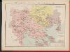
Carte des écoles et églises du vilayet de Salonique (1908)
Griechenland Selanik
Karta na čast' ot' južna Makedonija
1 : 210000 Makedonie
Solun
1 : 200000 Soluň (Řecko) Kartografska radionica
Džumaja
1 : 200000 Bulharsko Kartografska radionica
Stellungen der Armeen nach der Schlacht an der Bregalnica
Makedonien Bregalnica-Gebiet Balkankrieg <1912-1913>
Kriva Palanka
1 : 200000 Kriva Palanka (Makedonie) Militärgeographisches Institut
Vodena
1 : 200000 Kartografska radionica
Džumaja
1 : 200000 Militärgeographisches Institut
Oestliches Mazedonien
1 : 600000 Makedonien (Landschaft)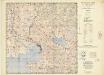
Balkans 1:100,000, Salonike
This is one sheet (C3672) of the topographical map series - Balkans 1:100,000 , Series GSGS 4087 - in 38 sheets, covering northern and central mainland Greece. The sheetlines are based on Mediterranean Grid. Originally, it was designated as "Not to be published". Great Britain. War Office. General Staff. Geographical Section. [London] : War Office
Westliches Mazedonien
1 : 600000 Makedonien (Landschaft)
Generalkarte von Zentraleuropa

Carte normale aeronautique internationale
1 : 200000 Geografike yperesia strarou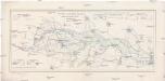
Starit čaltiški dămgi v gornata irigacionna sistema
1 : 40000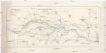
Gornja kanalna sistema na Mariča
1 : 40000
Tatar - Pazardžik - Kalugerovo
1 : 40000 Pazardžik (Bulharsko : oblast) Geografski Insitut
Izvod ot etnografskata karta na Ležana
Makedonien Ethnische Gruppe
[Mazedonien]
Makedonien
[Bălgarska zemja v Makedonija]
Makedonien Ethnische Gruppe Bulgaren
Izvod ot etnografskata karta na Mekenzi i Erbi
Makedonien Ethnische Gruppe
Etnografska karta na Makedonija
Makedonien Ethnische Gruppe
Carte ethnographique de la Macédoine, Point de vue bulgare
Makedonien Ethnische Gruppe Th. Weinreb del.
Carte ethnographique de la Macédoine, Point de vue serbe
Makedonien Ethnische Gruppe Th. Weinreb del.
Národopisná mapka Macedonie
Makedonie Král z Dobré Vody, Vojtěch Kančov, Vasil
Der von der IMRO geplante Mazedonische Staat
Makedonien Innere Makedonische Revolutionäre Organisation
Stellungen der Armeen vor und während der Schlacht an der Bregalnica (und unmittelbar nach derselben)
Makedonien Bregalnica-Gebiet Balkankrieg <1912-1913>
![[Macedonien]](https://images-2.georeferencer.com/images/iiif/622859362695/full/,300/0/native.jpg)

