Maps of Kalmyk
Partie des Gouvernemens d'Astracan et de Woronez; le Kabarda et partie du païs des Cosaques du Don
1 : 1400000 1 Karte : Kupferdruck ; 40 x 53 cm Rizzi-Zannoni, Giovanni Antonio [Santini-Remondini]
Partie, Russie d'Europe. Europe 23.
1 : 1641836 Vandermaelen, Philippe, 1795-1869
Wolga-Delta
1 : 2000000 Wolgadelta
General Charte der Laender Zwischen dem Schwarzen und Caspischen Meere : Circassien, Georgien, Armenien, Wüste von Astrachan und Caucasus hauptsoechlich die Grosse und Kleine Kabarda
1 : 1750000 Treuttel, Jean-Georges, 1744-1826 Joh. Georg Treuttel
Geologičeskaja karta Evropejskoj Rossii
1 : 2500000 Südost-Blatt Karpinskij, A.P. (Aleksandr Petrovič) Kartografičeskoe zavedenie A.Il'ina
Russia at the Caucasus.
1 : 3380000 Sharpe, J.
Uebersichts Karte der russischen Provinzen nördlich und südlich vom Kaukasus
1 : 2900000 Kavkaz (pohoří : oblast) Literarisch artistische Anstalt
Le cours de la riviere de Wolga, anciennement appellée Rha selon la relation d'Olearius / a Leide p
1 : 2500000 1 Karte : Kupferdruck ; 23 x 58 cm Olearius, Adam chez J. Covens et C. Mortier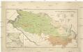
Mapa ruské národnosti na severním Kavkazsku
1 : 1080000 Kavkaz-oblast Chotek, Karel Česká společnost zeměvědná
Carte geographique representant le théatre de la guerre entre les Russes, les Turcs, et les Polonoi
1 : 1600000 1 Karte auf 3 Blättern : Kupferdruck ; 71 x 148 cm Lotter, Tobias Conrad [Tobias Konrad Lotter]
Feuille 27 (F IV), uit: Carte géologique internationale de l'Europe : la carte, votée au congrès géologique international de Bologne en 1881, est exécutée conformément aux décisions d'une commission internationale, avec le concours des gouvernements, sous le dir. de M.M. Beyrich et Hauchecorne
Annotatie: Blad 48 gamme des couleurs; blad 49: bladwijzer en titelblad Heinrich Ernst Beyrich 1815-1896; Wi. Hauchecorne Berlin : Reimer / (Berlin: Institut lithographique)
Nova Et Accurata Wolgae Fluminis, olim RHA dicti Delineatio [Karte, Teil 2], in: Novus atlas absolutissimus, Bd. 1, S. 87.
1 Karte aus Atlas Janssonius Offizin
Karta teatra vojny s Turcieju
1 : 350000 1 Karte : mehrfarbig ; 56 x 80 cm Kartograf. zavod A. Ilʹina
Charte der Laender am Caucasus
1 : 2100000 Kavkaz (pohoří : oblast) Reinecke, Johann Christoph Matthias
CHARTE der LAENDER AM CAUCASUS
1 : 2100000 Kavkaz-oblast Reinecke, Johann Christoph Matthias
Charte der Laender am Caucasus
1 : 2700000 Kavkaz-oblast Reinecke, Johann Christoph Matthias im Verlage des Geograph. Institut
Charte der Laender am Caucasus
1 : 2700000 Kavkaz-oblast Reinecke, Johann Christoph Matthias Geograph. Institut
Karta astrachanskoj huberniy so vključeniem' vnutrennej bukeevskoj ord'i
1 : 1680000 Astrachaň-oblast (Rusko)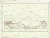
Plan des nivellirten Landstrichs zwischen dem schwarzen und caspischen Meere
1 : 1760000 Kaspické moře-oblast Reisen, E. Ramberg, F.
Caucasi montis nec non prov[inciae] Mingreliae, Imiretiae Georgiae Armeniae atq[ue] regionum vicinar
1 : 1700000 1 Karte : Kupferdruck ; 54 x 44 cm Logan, Johann Zacharias apud I. Z. Logan bibliop.
Mer Caspienne, carte marine (northern sheet)
1 : 1600000 Verden, Carl van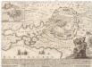
Accurateste und wahre Abbildung des russischen Lagers und Retrenchement vor der türckischen Haupt-Vestung Assoff, samt einem beygesezten Landkärtel, worinn die völlige Situation derselben zu ersehen
Azov (Rusko) Baeck, Elias Elias Baeck

Uebersichts Karte der Russischen Provinzen nördlich und südlich vom Kaukasus
1 : 2500000 München : in der literarisch artistischen Anstalt
Uebersichts Karte der russischen Provinzen nördlich und südlich vom Kaukasus
1 : 2900000 1 Karte : Kupferdruck ; 42 x 47 cm in der literarisch artistischen Anstalt
Nowaja Semlja zum Gouv. Archangelsk gehörig
1 : 8000000 1 Karte : Lithographie ; 26 x 19 cm Schlieben, W.E.A. von [Georg Joachim Göschen]
XXXX. Panzerkorps vom 30. 6. bis 30. 9. 1942
1 : 2500000 Kavkaz-oblast Korpskartenstelle
[Ost-Europa, Blatt 6]
Adolf Stieler's Handatlas über alle Theile der Erde und über das Weltgebäude Stieler, Adolf Justus Perthes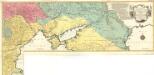
Carte Geographique representant le Théatre de la Guerre entre les Russes les Turcs, et les Polonois Confédérés
1 : 1600000 Mollova mapová sbírka Lotter, Tobias Conrad Lotter, Georg F. Lotter, Tobias Conrad