Maps of Zaporizhzhya

Nova mappa geographica maris Assoviensis vel de Zabache et paludis Maeotidis / accuratè aeri incisa
1 : 870000 1 Karte : Kupferdruck ; 47 x 56 cm [Matthäus Seutter]
Carte de la mer noire et de la mer d'Asow, 2
1 Blatt : 57 x 86 cm s.n.
Nova mappa geographica maris Assoviensis vel de Zabache et paludis Mæotidis
1 Karte : Kupferdruck ; 47 x 56 cm Seutter Matthäus Seutter
Carte de la Mer d'Azof et d'une partie de la Mer Noire / levée en 1774 par Monsieur Kinsbergen, Cap
1 : 1600000 1 Karte : Kupferdruck ; 19 x 45 cm Kinsbergen, Jan Hendrik van Froullé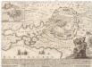
Accurateste und wahre Abbildung des russischen Lagers und Retrenchement vor der türckischen Haupt-Vestung Assoff, samt einem beygesezten Landkärtel, worinn die völlige Situation derselben zu ersehen
Azov (Rusko) Baeck, Elias Elias Baeck
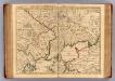
Verus chersonesi Tauricae seu Crimeae conspectus adjacentium item regionum / editus ex autographis C
1 : 970000 1 Karte : Kupferdruck ; 46 x 65 cm Frauendorff, Carl von apud R. & I. Ottens
Verus chersonesi Tauricae seu Crimeae conspectus adjacentium item regionum / editus ex autographis C
1 : 970000 1 Karte : Kupferdruck ; 46 x 65 cm Frauendorff, Carl von apud Joan Block
Spec. karta Ukrainy
1 : 420000 Krym (Ukrajina) vidannja Kartografičnogo vyddilu golovnoji geodezyčnoji upravy
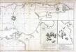
[Taurien oder Crim]
1 Karte : Kupferdruck ; 18 x 13 cm [Trattner]
Carte des embouchures du Tanais et des environs depuis Taigan, jusqu'a Nova-Krepa / Croisey scul.
1 : 310000 1 Karte : Kupferdruck ; 17 x 23 cm Bellin, Jacques Nicolas [Bellin]
Plan osady krěposti Anapy v 1828 gódu
1 : 30000
Plan krěposti Anapy
Russland Anapa Seeschlacht
Plan d'Azak où Azof / Croisey scul.
1 : 35000 1 Karte : Kupferdruck ; 21 x 16 cm Bellin, Jacques Nicolas [Bellin]
Moscowitische belagerung und Eroberung der Haubt-Stadt Asoff, im Tartarischen Königreich Nagaja am
1 Vogelschaukt. : Kupferdruck ; 26 x 34 cm Merian, Caspar [Merian's Erben]
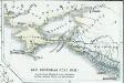
Plan Čortomlyckoj Siči
Ukraine Saporoschje (Region) Saporoger Kosaken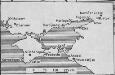
[Taurien]
Taurien (Gouvernement) Verwaltungsgliederung
Charte der Kriegs Operationen am Donn u: Dnieper Ihro Russisch Kayserl. Maiestaet glorieusen Armeen
1 : 1700000 1 Karte : Kupferdruck ; 38 x 44 cm (ganzes Blatt 54 x 64 cm) Seutter, Matthäus zu haben bey Matthaeus Seutter der röm: kayserl: u: königl: cathol: Majest: Geogr
Carte du gouvernement de Tauride comprenant la Krimée et les pays voisins
1 : 1150000 Krym (Ukrajina) par les freres Lotter
Théatre des opérations de la guerre dans la Tartarie du Cuban, Ozakow & Tartarie Crimée, avec les marches & rendés vous de l'armée de Russie contre les Turcs & Tartares, le tout suivant l'original de Pétersbourg, venant du camp de la Tartarie, Crimeé, mois de juillet [1]737
1 : 1680000 Ukrajina jižní Briffaut, E. chez le sieur Briffaut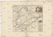
Theatre des operations de la guerre dans la Tartarie du Cuban Ozakow & Tartarie Crimée, avec les marches & rendés vous de l'armée de Russie contre les Turcs & Tartares, le tout suivant l'original de Petersbourg, venant du camp de la Tartarie Crimeé mois de juillet [1]737
1 : 1680000 Ukrajina jižní Briffaut, E. chez le sieur Briffaut
Scythia Europaea Et Asiatica Cum Chersoneso Taurica Ante et Post Christum Natum ad Seculum V
1 : 6500000 Mollova mapová sbírka
Theatre de la guerre, Petite Tartarie, Crimee, Mer Noire.
1 : 1250000 L'Isle, Guillaume de, 1675-1726
Cimmeria, quae Postea Scythia Europaea Seu Parva Scythia / Ex Conatibus Geographicis Gulielmi Sanson
1 : 3000000 1 Karte : Kupferdruck ; 38 x 48 cm Sanson, Guillaume Apud I. Covens et C. Mortier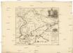
Carte generale des expeditions militaires des armées victorieuses de sa Maieste imperiale de toutes les Russies sur le Don et le Dnepr l'an 1736
1 : 1690000 Dněpr-oblast
A map of the lesser Tartary / done from the original, published by the Imperial Academy of Sciences
1 : 1700000 1 Karte : Kupferdruck ; 39 x 45 cm Senex, John [Iohn Senex]
Theatrum belli Ao. MDCCXXXVII a milite Augustae Russorum Imperatricis adversus Turcas Tattarosque ge
1 : 1900000 1 Karte : Kupferdruck ; 46 x 65 cm apud R. & I. Ottens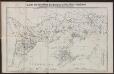
Karte der deutschen Siedlungen in Neu (Süd)-Rußland
Russland Russland