Maps of Africa
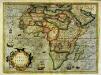
Nova Africæ tabula
1 Karte : Kupferdruck ; 35 x 48 cm Mercator; Hondius excusum in ædibus auctoris
Nova Africæ tabula
1 Karte : Kupferdruck ; 36 x 48 cm Hondius excusum in ædibus auctoris
Africa
1 : 18050000 Afrika Weiland, Karl Ferdinand Verlag des Geograph. Instituts
Africa
1 : 18000000 Afrika Weiland, Karl Ferdinand Verlag des Geographischen Institut
Africa ex magnæ orbis terræ descriptione
1 Karte : Kupferdruck ; 36 x 48 cm Mazza; Rasciotti s.n.
Africae tabvla nova
1 Karte : Kupferdruck ; 37 x 49 cm Ortelius s.n.
Africae tabvla nova
1 Karte : Kupferdruck ; 37 x 49 cm Ortelius s.n.
Karte von Africa
1 : 17500000 Afrika Benedicti, Hieronymus Franz. Joh. Jos. von Reilly
Africa
Afrika Schmidt, Johann Marius Friedrich Richter, Johann Carl S. Schropp & Comp.
Africa
Afrika Schmidt, I. M. F. Schropp, Simon S. Schropp & Comp.
Charte von Africa
1 : 17500000 Afrika Johannes Walch
Africa
1 : 20000000 Afrika Hase, Johann Matthias Hommannianos Heredes
Africa
1 : 47750000 Afrika Radefeld, Carl Christian Franz Meyer, Joseph Bibliographisches Institut
[Kaart], uit: Karte von Afrika / entworfen von F. Handtke ; bearbeitet und ergänzt im kartographischen Institut der Verlagshandlung
1 : 14500000 titelvariant: General-Karte von Afrika; Annotatie: Omslagtitel: General-Karte von Afrika; Annotatie geografische gegevens: Schaalstokken; Inzetkrt.: Das Deutsche Reich. - 1.14.500.000; Das mittlere Ost-Afrika. - 1.6.000.000. - Zum Vergleich: [Kgr. Sachsen] (elfde schaal); I. Lüderitz-Land (der südliche Theil von Deutsch-Südwestafrika, II. Das Kamerun-Gebiet, III. Togo-Gebiet und Sklavenküste (alle 1:3.000.000). - [Zum Vergleich:] Das Königr. Sachsen (zelfde schaal) Verlag von Carl Flemming, Glogau. Kartographisches Institut Glogau : Carl Flemming
Africa
1 : 16000000 nach Robert [de] Vaugondy, Rennell's und Sotzmann's Skizze des nördlichen Theils von Africa, nach den Geographischen Nachrichten welche die Africanische Gesellschaft gesammelt hat Robert Sayer, Lemprier, Sparrmann, Bruce, Niebuhr, Robert, Dapres [etc.] entworfen und hrsg. im Jahre 1807 Nürnberg : Schneider und Weigel
Africa quantum veteribus nota
1 : 34000000 Afrika in officina artium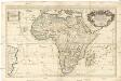
L'Afrique
1 : 17800000 Afrika Sanson, Nicolas Cordier, Louis Hubert Iaillot
CHARTE von AFRICA
1 : 30000000 Afrika
Charte von Africa
1 : 30000000 Afrika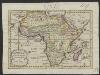
Afrika, volgens de nieuwste waarnemingen
1 : 74000000 Te Amsterdam : by Arend Fokke, Simz.
Africa.
1 : 50000000 Seaman, James V.
Africa
1 : 18050000 Afrika Weiland, Karl Ferdinand Verlag des Geograph. Instituts
Afica.
1 : 28500000 Tanner, Henry S.
Africa
1 : 31000000 Afrika
Map of Africa
1 : 7000000 Tanner, Henry S.
Afrika
1 : 52860000 Afrika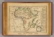
L'Afrique.
1 : 50000000 Delamarche, Charles Francois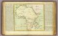
L'Afrique isles, caps, ports.
1 : 28000000 Clouet, J. B. L. (Jean-Baptiste Louis), b. 1730
Africa
1 : 29000000 Afrika Schmit, J. M. F. Tranquillo Mollo


