Maps of Landkreis Breisgau-Hochschwarzwald

Accurata delineatio Brisgoviæ
1 Karte : Kupferdruck ; 56 x 48 cm Seutter; Drentwett Matthäus Seutter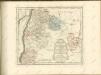

Imp. Caes. Carolo VI. Avgvsto pio victori gentis svae sideri felicissimo chorographiam hanc exhibentem primar. regionvm Habspvrgicar. sitvm positvmq. brevibvs exterarvm ditionvm intervallis vt permistvm et implicatvm ita variis tvrbis expositvm nec non vltimos Imperii Germ. terminos perpetva transitvvm obsidionvm Hibernorvm coactionvm vexatione agitatos antiqvae fidei et invictae testes pietatis svpplexdicat provincia Brisgoia
1 : 42000 Homann, Johann Baptist Ioh. Bapt. Homann
Cursus Rheni supra Argentoratum et Regiones Adiacentes
1 : 2900000 Mollova mapová sbírka Seutter, Matthäus Seutter, Matthäus
Geographica Sueviæ universæ descriptio, 3
1 Blatt : Homännische Erben
Provincia Brisgoia avst. ant
1 Karte : Kupferdruck ; 57 x 47 cm Homann Johann Baptist Homann
Die obere Markgrafschaft Baaden oder die Markgrafschaft Hochberg
1 Karte : Kupferdruck ; 21 x 24 cm Reilly F. J. J. von Reilly
Superioris Alsatiæ nec non Brisigaviæ et Suntgaviæ geographica tabula
1 Karte : Kupferdruck ; 45 x 55 cm Visscher; Schenk nunc apud Petrum Schenk jun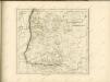

Superioris Alsatiae nec non Brisigaviae et Suntgaviae Geographica Tabula
1 : 280000 Mollova mapová sbírka Visscher, Nicolaes Jansz. Schenk, Peter II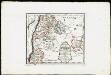
Die obere Markgrafschaft Baden oder die Markgrafschaft Hochberg, Landgrafschaft Sausenberg, und die Herrschaften Röteln und Baadenweiler mit den Herrschaften Hausen und Hohengeroldseck,...
Reilly, Franz Johann Joseph von
Fernere Erweiterung unserer weiteren Kriegs Progressen von den 11ten Aug: biß 12ten Octob:
Mollova mapová sbírka Lidl, Johann Jakob Lidl, Johann Jacob
Ganz neue Vorstellung des Rhein_Stroms von Basel bis Coblenz...

Suevia universa IX. tabulis delineata, 7
1 Blatt : s.n.
L'Alsazia diuisa nel Langrauiato dell'Alta e della Bassa Alsazia, nella Suntgouia, nell'Ortnauia, e nella Brisgouia
Mollova mapová sbírka Cantelli, Giacomo Donia, Francesco De Rossi, Giovanni Giacomo
Freiburg 141, uit: [W. Liebenow's Special-Karte von Mittel-Europa]
1 : 300000 titelvariant: W. Liebenow's Mittel-Europa; Annotatie: Titel boven de bladen: W. Liebenow's Mittel-Europa Johannes Wilhelm Liebenow 1822-1897 Hannover : Hermann Oppermann
Freiburg 141, uit: Special-Karte von Mittel-Europa / nach amtlichen Quellen bearbeitet von W. Liebenow
1 : 300000 titelvariant: W. Liebenow's Mittel-Europa; Annotatie: Titel boven de bladen: W. Liebenow's Mittel-Europa Johannes Wilhelm Liebenow 1822-1897 Frankfurt a. M. : Ludwig Ravenstein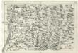
Geographica Provinciarum Sveviae Descriptio =
Mollova mapová sbírka Hurter, Johann Christoph Bodenehr, Johann Georg
185. Freiburg i. Brg., uit: Topographische Uebersichtskarte des Deutschen Reiches / herausgegeben v. d. Kartogr. Abt. d. Königl. Preuß. Landesaufnahme
1 : 200000 titelvariant: Topogr. Übersichtskarte des Deutschen Reiches; Annotatie: Titel boven bladen ook: Topogr. Übersichtskarte des Deutschen Reiches; Annotatie geografische gegevens: Op elk blad twee maatstokken: 10 Kilometer = 5,5 cm; 1 geogr. Meile = 3,6 cm; Legenda onder op elk blad Königlich Preußische Landesaufnahme. Kartographische Abtheilung [S.l : Königlich Preußische Landesaufnahme, Kartographische Abtheilung]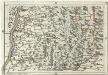
Geographica Provinciarum Sveviae Descriptio =
Mollova mapová sbírka Hurter, Johann Christoph Bodenehr, Gabriel
Suevia Universa :
1 : 170000 Mollova mapová sbírka Michal, Jacques de Seutter, Matthäus Seutter, Matthäus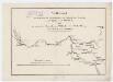
Vergleich zwischen der Strecke der Nordostbahn von Zürich über Dietikon und Baden AG nach Waldshut (Deutschland) und der projektierten Strecke von Wallisellen über Niederweningen oder Weiach nach Waldshut (Deutschland); Grundriss
1 : 300000 Ohne Datumsangabe.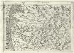
Geographica Provinciarum Sveviae Descriptio =
Mollova mapová sbírka Hurter, Johann Christoph Bodenehr, Johann Georg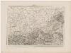
Topographische Karte der Schweiz (Dufour-Karte): Den Kanton Zürich betreffende Blätter: Blatt III: Liestal, Schaffhausen
1 : 100000 Erstausgabe 1849; Nachführung 1866. Leitung: Dufour, Guillaume-Henri (1787-1875), General, Politiker, Ingenieur und Kartograf, von Genf; Eidgenössisches Topographisches Bureau, in Genf Stich: Bressanini, Rinaldo (1803-1864), Kupferstecher und Kartograf, von Italien; Müllhaupt, Heinrich (1820-1894), Kupferstecher und Kartograf, von Hofstetten Druck: Koegel, Henri (1816-1867)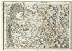
Geographica Provinciarum Sveviae Descriptio =
Mollova mapová sbírka Hurter, Johann Christoph Bodenehr, Gabriel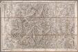
Rottweil
1 : 100000 Annotatie: Linksonder: T-28 [Paris : Depôt de la Guerre]
Blatt III: Liestal, Schaffhausen, uit: Topographische Karte der Schweiz / vermessen und hrsg. ... unter Aufsicht des Generals G.H. Dufour
1 : 100000 Annotatie: Met plaatsnamenregister (bl. V), bladwijzer (bl. XXI) en hoogteregister (bl. XXV); Voor aanwezige bladen zie overzichtsblad Dufour, G. H. [Bern : Eidg. Topogr. Bureau]
Topographische Karte der Schweiz
1 : 100000 25 Karten vermessen und hrsg. auf Befehl der Eidgenössischen Behörden ; aufgenommen unter der Aufsicht des Generals G.H. Dufour Eidg. Topographisches Bureau, [Genève], [später: Bern]
Liestal, Schaffhausen
1 : 100000 1 Karte geologische Aufnahmen von C. Moesch, U. Stutz u. Insp. Vogelgesang [Wurster & Randegger], [Winterthur]


