Maps of Baden-Württemberg

Wirtenberg dvcatvs
1 Karte : Kupferdruck ; 35 x 42 cm Janssonius van Waesbergen; Pitt; Swart apud Janssonio-Waesbergios Mosem Pitt et Stephanum Swart
Wirtenberg dvcatvs
1 Karte : Kupferdruck ; 40 x 48 cm Blaeu; Blaeu Willem und Joan Blaeu
Ducatus Würtenbergici
1 Karte : Kupferdruck ; 47 x 58 cm Majer; Schenk Pieter Schenk
Wirtenberg Ducatus [Karte], in: Gerardi Mercatoris Atlas, sive, Cosmographicae meditationes de fabrica mundi et fabricati figura, S. 361.
1 Karte aus Atlas Mercator, Gerhard Montanus, Petrus
Wirtenberg Ducatus. [Karte], in: Novus atlas absolutissimus, Bd. 2, S. 211.
1 Karte aus Atlas Janssonius Offizin
Wirtenberg dvcatvs
1 Karte : Kupferdruck ; 35 x 43 cm Janssonius; Mercator excusum apud Ioannem Ianssonium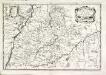
Wirtenberg dvcatus
1 Karte : Kupferdruck ; 19 x 28 cm Merian Merian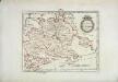
Das Herzogthum Würtemberg
1 Karte : Kupferdruck ; 23 x 30 cm Reilly F. J. J. von Reilly
Wirtenberg Ducatus. [Karte], in: Novus Atlas, das ist, Weltbeschreibung, Bd. 1, S. 231.
1 Karte aus Atlas Blaeu, Joan Blaeu, Willem Janszoon
Wirtenberg Ducatus [Karte], in: Gerardi Mercatoris et I. Hondii Newer Atlas, oder, Grosses Weltbuch, Bd. 1, S. 230.
1 Karte aus Atlas Mercator, Gerhard und Hondius, Jodocus Jansson, Jan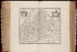
Wirtenberg dvcatvs
1 : 510000 Annotatie: Origineel is Blad 111 in atlas factice; Linksboven: wapen van Hertogdom Württemberg; Vermelding rechtsboven: XLV; Annotatie geografische gegevens: Schaalvermelding op kaart: Milliaria Germanica communia Johannes Janssonius van Waesberge -1681?; Moses Pitt ca. 1654-1696; Stephanus Swart [Oxford : apud Janssonio-Waesbergios, Mosem Pitt et Stephanum Swart]
Les Cours de Postes par le Cercle de Suabe, come ils se presentent dans la Carte Geographique
1 : 130000 Mollova mapová sbírka Homann, Johann Baptist Homann, Johann Baptista - dědici
Special Post Karte durch den schwaebischen Kreis
1 Karte : Kupferdruck ; 43 x 53 cm Homännische Erben
Special Post Karte durch den schwaebischen Kreis
1 Karte : Kupferdruck ; 43 x 54 cm Homännische Erben
Special Post Karte durch den schwaebischen Kreis
1 Karte : Kupferdruck ; 43 x 54 cm Homännische Erben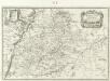
Wirtenberg Dvcatus
1 : 1000000 Mollova mapová sbírka Merian, Matthaeus Merian, Matthäus

Das Kœnigreich Würtemberg nebst dem Grosherzogthum Baaden, den Fürstenthümern Hohenzollern und Layen
1 Karte : Kupferdruck ; 59 x 53 cm Pflummern in A. G. Schneider u: Weigels kön: priv: Kunst u: Landkartenhandlung
Wirtenberg Ducatus. [Karte], in: Le théâtre du monde, ou, Nouvel atlas contenant les chartes et descriptions de tous les païs de la terre, Bd. 1, S. 260.
1 Karte aus Atlas Blaeu, Willem Janszoon und Blaeu, Joan Blaeu, Willem Janszoon
Geographica provinciarum Sveviae descriptio
Švábsko (Německo) Hurter, Johann Christoph Bodenehr, Gabriel Hanß Georg Bodenehr
[Geographica provinciarum Sveviae descriptio]
Švábsko (Německo) Hurter, Johann Christoph Bodenehr, Johann Georg bey Hanß Georg Bodenehr
Länder in Südwestdeutschland 1947
Land Baden, Württemberg-Hohenzollern Kunz, Andreas ; Treiling, Thomas ; Moeschl, Joachim
Wurtemberg, Baden.
1 : 450000 Weiland, C. F. (Carl Ferdinand), d. 1847
Wirtenberg dvcatvs
1 : 470000 Württembersko (Německo) Mercator, Gerhard
Le Cercle de Souabe et partie de Celuy de Franconie
1 : 600000 Mollova mapová sbírka Fer, Nicolas de Inselin, Charles Fer, Nicolas de
Cours du Danube feuille I contenant la Suabe ou est exactement marquée la succession de Charles VI
1 Karte : Kupferdruck ; 47 x 55 cm Le Rouge chez le Rouge rue des Augustins vis a vis le Panier Fleuri
Wirtenbergensis Ducatus Vera Descriptio, Tubingae Edita. 1558. [Karte], in: Theatrum orbis terrarum, S. 75.
1 Karte aus Atlas Ortelius, Abraham
Karte vom Königreich Wirtemberg nebst dem Fürstenthum Hohenzollern-Sigmaringen und Sigmaringen
1 : 440000 Sigmaringen (Německo) Walch, Johann Joh. Walch
Karte vom Königreich Wirtemberg nebst dem Fürstenthum Hohenzollern-Sigmaringen
1 : 440000 Württembersko (Německo) Walch, Johann Joh. Walch


