Maps of Salzburg

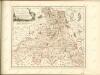
L'archeveché de Saltzbourg
1 Karte : Kupferdruck ; 48 x 55 cm Le Rouge Georges Louis Le Rouge rue des Grands Augustins
Provincia archiepiscopatus Salisburgensis
1 Karte : Kupferdruck ; 25 x 35 cm Gutwein; Hansiz M. Happach & F.X. Schlüter

S. R. I. principat. et archiepiscopatus Salisburgensis mappa geographica
1 Karte : Kupferdruck ; 48 x 56 cm Lotter Tobias Konrad Lotter
S. R. I. principat. et archiepiscopatus Salisburgensis mappa geographica
1 Karte : Kupferdruck ; 48 x 56 cm Seutter Matthäus Seutter
[München-Linz-Bruck].
1 : 576000 Rakousko Blumtritt, H. Oesfeld, C. W.
Sheet VII: Karte Des Oesterreichischen Kaiserstaates.
1 : 576000 Scheda, Josef
Salisburgensis Iurisdictionis, locorumque vicinorum vera descriptio [Karte], in: Theatrum orbis terrarum, S. 260.
1 Karte aus Atlas Ortelius, Abraham Vrients, Jan Baptista
Das Erzstift Salzburg mit der gefürsteten Probstey Berchtesgaden
1 Karte : Kupferdruck ; 23 x 27 cm Reilly F. J. J. von Reilly
Salisburgensis Iurisdictionis, locorumque vicinorum vera descriptio [Karte], in: Theatrum orbis terrarum, S. 70.
1 Karte aus Atlas Ortelius, Abraham
S. R. I. principatvs et archiepiscopatus Salisburgensis
1 Karte : Kupferdruck ; 47 x 57 cm Guetrather; Homann Johann Baptist Homann
Salisburgensis Iurisdictionis, locorumque vicinorum vera descriptio [Karte], in: Theatrum orbis terrarum, S. 168.
1 Karte aus Atlas Ortelius, Abraham
VII, uit: General-Karte des oesterreichischen Kaiserstaates mit einem grossen Theile der angrenzenden Länder / durch Josef Scheda ... bearb. und hrsg
1 : 576000 Annotatie geografische gegevens: Maatstokken: oesterreichische Meilen, geografische oder deutsche Meilen, preussische Meilen, türkische Berri, französische Lieues, russische Werste; Maatstok per blad: wiener Klafter, öster. Meilen; Blad XIX: statistische en taalkundige informatie; Blad XIX: legenda [Wien : K.K. Militärisch-Geografisches Institut]
Saltzbvrg archiepiscopatvs, et Carinthia dvcatvs
1 Karte : Kupferdruck ; 37 x 49 cm Mercator; Blaeu apud Guiljelmum Blaeu
S. R. I. Principatus et Archiepiscopatus Salisburgensis
1 : 430000 Mollova mapová sbírka Homann, Johann Baptist Homann, Johann Baptista
S. R. I. Principat. et Archiepiscopatus Salisburgensis
1 : 430000 Mollova mapová sbírka Seutter, Matthäus Seutter, Matthäus
Strassen und Gebirgs-Karte zur Reise von Wien durch Österreich, Salzburg, Kärnthen, Steyermark und Tyrol bis München : mit Berücksichtigung der oesterreichischen Alpen und des Bayerischen Hochgebirgs
Artaria Co.
t'Aartsbisdom Saltzburg
1 : 1000000 gelegen na de stelling van de Hr. G. de l'Isle Deventer [etc.] : [by J. de Lat [etc.]
Saltzburg Archiepiscopatus, et Carinthia Ducatus. [Karte], in: Novus Atlas, das ist, Weltbeschreibung, Bd. 1, S. 219.
1 Karte aus Atlas Blaeu, Joan Blaeu, Willem Janszoon
Saltzburg Archiepiscopatus, et Carinthia Ducatus. [Karte], in: Le théâtre du monde, ou, Nouvel atlas contenant les chartes et descriptions de tous les païs de la terre, Bd. 1, S. 248.
1 Karte aus Atlas Blaeu, Willem Janszoon und Blaeu, Joan Blaeu, Willem Janszoon
Saltzbvrg archiepiscopatvs, et Carinthia dvcatvs
1 Karte : Kupferdruck ; 36 x 48 cm Mercator; Janssonius apud Ioannem Ianssonium
Saltzbvrg archiepiscopatvs, et Carinthia dvcatvs
1 Karte : Kupferdruck ; 36 x 47 cm Mercator; Valck; Schenk apud G. Valk et P. Schenk
Charte von Salzburg, Passau, Aichstædt und Berchtesgaden
1 Karte : Kupferdruck ; 45 x 55 cm Kipferling Im Verlage des Kunst und Industrie Comptoirs
Saltzburg Archiepiscopatus, et Carinthia Ducatus. [Karte], in: Theatrum orbis terrarum, sive, Atlas novus, Bd. 1, S. 274.
1 Karte aus Atlas Blaeu, Joan Blaeu, Willem Janszoon
Saltzburg archiepiscopatus cum ducatu Carinthiae [Karte], in: Gerardi Mercatoris et I. Hondii Newer Atlas, oder, Grosses Weltbuch, Bd. 1, S. 337.
1 Karte aus Atlas Mercator, Gerhard und Hondius, Jodocus Jansson, Jan
Saltzburg archiepiscopatus cum ducatu Carinthiae [Karte], in: Gerardi Mercatoris Atlas, sive, Cosmographicae meditationes de fabrica mundi et fabricati figura, S. 406.
1 Karte aus Atlas Mercator, Gerhard Montanus, Petrus
Saltzburg Archiepiscopatus, et Carinthia Ducatus [Karte], in: Novus atlas absolutissimus, Bd. 2, S. 279.
1 Karte aus Atlas Janssonius Offizin


