Maps of Landkreis Aichach-Friedberg

Pars IV. monstrat mediam partem ducat: Bavariæ, urbem jmp: Augustam Vindelicorum, cum parte ducat Neoburg, et episc. Frising
1 Karte : 54 x 52 cm Heinrich Ludwig Broenner
Monstrat mediam Partem Ducat: Bavariæ, Urbem Jmp: Augustam Vindelicorum, cum Parte Ducat Neoburg, et Episc. Frising
1 : 150000 Mollova mapová sbírka Buna, Wilhelm C. Broenner, Heinrich Ludwig
Ingolstad 129, uit: Special-Karte von Mittel-Europa / nach amtlichen Quellen bearbeitet von W. Liebenow
1 : 300000 titelvariant: W. Liebenow's Mittel-Europa; Annotatie: Titel boven de bladen: W. Liebenow's Mittel-Europa Johannes Wilhelm Liebenow 1822-1897 Frankfurt a. M. : Ludwig Ravenstein
München - Augsburg - Ulm
Hilkerzhausen, Inderstorff, Ottenburg a okolí]
Mollova mapová sbírka Bodenehr, Gabriel Bodenehr, Gabriel
Suevia Universa :
1 : 170000 Mollova mapová sbírka Michal, Jacques de Seutter, Matthäus Seutter, Matthäus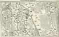
Marggraffschafft Burgau
Mollova mapová sbírka Bodenehr, Gabriel Bodenehr, Gabriel
172. Nördlingen, uit: Topographische Uebersichtskarte des Deutschen Reiches / herausgegeben v. d. Kartogr. Abt. d. Königl. Preuß. Landesaufnahme
1 : 200000 titelvariant: Topogr. Übersichtskarte des Deutschen Reiches; Annotatie: Titel boven bladen ook: Topogr. Übersichtskarte des Deutschen Reiches; Annotatie geografische gegevens: Op elk blad twee maatstokken: 10 Kilometer = 5,5 cm; 1 geogr. Meile = 3,6 cm; Legenda onder op elk blad Königlich Preußische Landesaufnahme. Kartographische Abtheilung [S.l : Königlich Preußische Landesaufnahme, Kartographische Abtheilung]
Weitere Fortsetzung des heurigen Kriegs Theatri
Mollova mapová sbírka Lidl, Johann Jakob Lidl, Johann Jacob
Augsburg mit der gegend auf 2 Stunden.
1 : 150000 Mollova mapová sbírka Bodenehr, Gabriel Bodenehr, Gabriel
Bairische Landtafeln XXIIII. Darinnē das hochlöblich Furstenthumb Obern unnd Nidern Bayrn sambt der Obern Pflaz Erz unnd Stifft Salzburg Eichstet unnd andern mehrern anstossenden Herschafftē]
1 : 145000 Mollova mapová sbírka Apian, Philipp Amman, Jost Apian, Petrus
Bairische Landtafeln XXIIII. Darinnē das hochlöblich Furstenthumb Obern unnd Nidern Bayrn sambt der Obern Pflaz Erz unnd Stifft Salzburg Eichstet unnd andern mehrern anstossenden Herschafftē]
1 : 145000 Mollova mapová sbírka Apian, Philipp Amman, Jost Apian, Petrus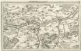
Ingolstatt mit der Gegend
Mollova mapová sbírka Riegel, Christoph Bodenehr, Gabriel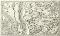
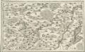
Thierhaupten, Pöttmess, Gumpenberg, Küebach a okolí]
Mollova mapová sbírka Bodenehr, Gabriel Bodenehr, Gabriel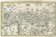
Gegend zwischen Neuburg und Donauwerth.
1 : 140000 Mollova mapová sbírka Bodenehr, Gabriel Bodenehr, Gabriel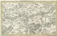
Ingolstatt mit der Gegend.
Mollova mapová sbírka Bodenehr, Gabriel Bodenehr, Gabriel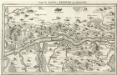
Gegend zwischen Neuburg und Donauwerth
Mollova mapová sbírka Bodenehr, Gabriel Bodenehr, Gabriel
Neuburg an der Donau mit der Gegend auf 2 Stund.
1 : 170000 Mollova mapová sbírka Bodenehr, Gabriel Bodenehr, Gabriel
Augspurg mit umliegender Gegend und dabey verschanzten Französisch-Bayrischen Lager
1 : 40000 Mollova mapová sbírka Weigel, Johann Christoph Weigel, Christoph I.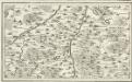
Pfaffenhofen, Schrobenhausen a okolí]
Mollova mapová sbírka Bodenehr, Gabriel Bodenehr, Gabriel
A plan of the famous victory at Bleinem obtained by His Grace the Duke of Malborough over the Elector of Bavaria and the Marechals Tallard and Marcin, the 13th August, 1704 S.N
1 : 20000 J. van Vianen fecit [Amsterdam] : Reynerus Leers excudit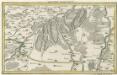
München mit der Gegend.
1 : 140000 Mollova mapová sbírka Bodenehr, Gabriel Bodenehr, Gabriel
Plan of the glorious Battle of Hochstet
Plan of the glorious Battle of Hochstet [or Blenheim]. ... For Tindal's Continuation of Rapin's History of England. [London]
Bobingen, Liechtenberg, Babern, Möhringen a okolí]
Mollova mapová sbírka Bodenehr, Gabriel Bodenehr, Gabriel
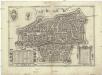
Augspurg
1 Karte : Kupferdruck ; 27 x 34 cm Weigel Christoph Weigel
Augspurg die Haupt-Stadt und Zierde des Schwaebischen Craises
1 : 50000 Mollova mapová sbírka Seutter, Matthäus Seutter, Matthäus
Speciální mapy okolí různých měst

Unter allen Schlachten dieses Seculi hat die Höchste Stadt die Schlacht bey Höchstädt geschehen den 13. Aug. 1704

Neuester Plan von Augsburg
Wirth