Maps of Erzgebirge

Carte topographique d'Allemagne contenant une partie du royaume de Boheme, une partie de la Saxe
1 Karte : Kupferdruck ; 46 x 61 cm Jaeger; Hauer se vend chez I. W. A. Iaeger
S. R. Imp. Circuli Franconici Geographica Delineatio Francken-Land mit Seinen Gräntzen
Mollova mapová sbírka Endter, Wolfgang Moritz Endter, Wolfgang Moritz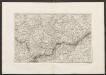
Militair Karte von Süd-Deutschland in 20 Sectionen
1 : 400000 3. Section Coulon, Alois von A. von Coulon
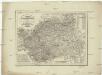
TERRA ADVOCATORVM | Vulgo | VOIGHTLAND
Descripta ab Olao Ioannis Gotho | S.R.M. Sueciæ Geographo. Amstelædami | J. Blaeu excudebat.
Terra Advocatorvm vulgo Voightland
1 : 290000 Vogtland (Německo) Örnehufvud, Olof Hansson Blaeu, Joan J. Blaeu
Terra Advocatorvm Vulgo Voightland
1 : 290000 Mollova mapová sbírka Örnehufvud, Olof Hansson Blaeu, Joan I.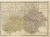
Elbogner dan Saatzer Kreis und Egerische = Gebiet
Mappa geographica regni Bohemiae in duodecim circuloc divisae ... Sectio. VI.

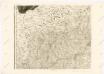
Der nordwestliche Theil Böhmens
1 : 120000 Drážďany-oblast (Německo) Franieck
Franzensbad und Seine Umgebung
Charte vom Elbogner Kreise mit dem Egerischen Bezirk und dem Kronlehn Gut Asch
1 : 260000 Aš-oblast (Česko) Kreibich, František Jakub Jindřich Kettner, C. C. W. Enders
Charte vom Elbogner Kreise mit dem Egerischen Bezirk und dem Kronlehn Gut Asch
1 : 260000 Aš-oblast (Česko) Kreibich, František Jakub Jindřich Kettner, C. C. W. Enders
Charte vom Elbogner Kreise mit dem Egerischen Bezirk und dem Kronlehn Gut Asch
1 : 241000 Aš-oblast (Česko) Kreibich, František Jakub Jindřich Enders, C. W. C.W. Enders
Charte vom Elbogner Kreise mit dem Egerischen Bezirk und dem Kronlehn Gut Asch
1 : 241000 Aš-oblast (Česko) Kreibich, František Jakub Jindřich Enders, C. W. C.W. Enders
Charte vom Elbogner Kreise mit dem Egerischen Bezirk und dem Kronlehn Gut Asch
1 : 241000 Aš-oblast (Česko) Kreibich, František Jakub Jindřich Enders, C. W. C.W. Enders
Charte vom Elbogner Kreise mit dem Egerischen Bezirk und dem Kronlehn Gut Asch
1 : 241000 Aš-oblast (Česko) Kreibich, František Jakub Jindřich Enders, C. W. C.W. Enders
Charte vom Elbogner Kreise mit dem Egerischen Bezirk und dem Kronlehn Gut Asch
1 : 241000 Aš-oblast (Česko) Kreibich, František Jakub Jindřich Enders, C. W. C.W. Enders
Charte vom Elbogner Kreise mit dem Egerischen Bezirk und dem Kronlehn Gut Asch
1 : 241000 Aš-oblast (Česko) Kreibich, František Jakub Jindřich Enders, C. W. C.W. Enders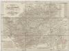
Charte vom Elbogner Kreise mit dem Egerischen Bezirk und dem Kronlehn Gut Asch
1 : 241000 Aš-oblast (Česko) Kreibich, František Jakub Jindřich Enders, C. W. C.W. Enders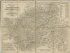
Charte vom Elbogner Kreise mit dem Egerischen Bezirk...

Charte vom Elbogner Kreise ...

Charte vom Elbogner Kreise ...

Repraesentatio Geographica District Egerani nunc Circulo Cubitensi in quo simul viae Egeranae in Thermas Carolinas in distincta delineatio conspicitur
1 : 200000 Cheb-oblast (Česko) Müller, Johann Christoph apud Homannianos Heredes
Kraj Karlovarský

Geognostische Karte der Umgebungen von Carlsbad, Franzensbad und Marienbad
1 : 144000 Františkovy Lázně-oblast (Česko)
Repraesentatio geographica circvli Egerani, nec non Elnbogensis, in quo simul viae Egeranae in Thermas Carolinas distincta delineato conscriptur
1 : 136000 Cheb-oblast (Česko) Müller, Johann Christoph apud Homannianos Heredes
[Repraesentatio geographica circvli Egerani, nec non Elnbo]gensis, in quo simul viae Egeranae in Thermas Carolinas distincta delineato conscriptur
1 : 136000 Cheb-oblast (Česko) Müller, Johann Christoph apud Homannianos Heredes
[Rep]raesentatio geographica circvli Egerani, nec non Elnbo[ge]nsis, in quo simul viae Egeranae in Thermas Carolinas distincta delineato con[scrip]tur
1 : 136000 Cheb-oblast (Česko) Müller, Johann Christoph apud Homannianos Heredes
Repraesentatio geographica circvli Egerani, nec non Elnbogensis, in quo simul viae Egeranae in Thermas Carolinas distincta delineato conscriptur
1 : 136000 Cheb-oblast (Česko) Müller, Johann Christoph apud Homannianos Heredes


