Maps of Liguria

Pedemontanae vicinorvmqve regionvm
1 Karte : Kupferdruck ; 36 x 49 cm Gastaldi; Ortelius s.n.
Pedemontanae vicinorvmqve regionvm
1 Karte : Kupferdruck ; 36 x 49 cm Gastaldi; Ortelius s.n.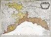
Partie du duché de Milan, la principauté de Piémont, le Montferrat; et la republi.que de Genes
1 Karte : Kupferdruck ; 45 x 63 cm Jaillot; Simonneau chez H. Iaillot geographe ordinaire du roy proche les grands Augustins aux 2. globes
REIPUBLICAE GENUENSIS DOMINIUM
1 : 630000 Janov-oblast (Itálie) Seutter, Matthäus per Matth. Seutter
Riviera Di Genova Da Ponente [Karte], in: Theatrum orbis terrarum, sive, Atlas novus, Bd. 3, S. 52.
1 Karte aus Atlas Blaeu, Joan Blaeu, Willem Janszoon
Riuiera di Genova da Ponente
1 : 450000 Mollova mapová sbírka Magini, Giovanni Antonio Wright, Benjamin Magini, Fabio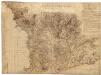
Descrittione Delle Langhe Piamonte et Montferrato, È Svoi Confini con lé Strade che vengono dal Disbarco della Manna al Sto. di Milo
Mollova mapová sbírka
Riviera Di Genova Da Ponente [Karte], in: Novus Atlas, das ist, Weltbeschreibung, Bd. 3, S. 60.
1 Karte aus Atlas Blaeu, Joan Blaeu, Willem Janszoon

MAPPA GEOGRAPHICA STATVS GENVENSIS
1 : 460000 Janov-oblast (Itálie) Mayer, Tobias Chafrion, José in lucem proferentibus Homannianis Heredibvs
MAPPA GEOGRAPHICA STATVS GENVENSIS
1 : 460000 Janov-oblast (Itálie) Mayer, Tobias Chafrion, José in lucem proferentibus Homannianis Heredibvs
Topographia de la Liguria
1 : 170000 Mollova mapová sbírka Chafrion, José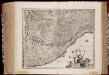
Riviera di Genova di Ponente
1 : 400000 Annotatie: In tegenstelling tot eerdere uitgaven van Johannes Janssonius bevat deze kaart een afwijkend cartouche in de vorm van een afbeelding van Neptunus geflankeerd door paarden en putti, waarbij 1 van de putti een banier vasthoudt met daarop de titel van de kaart; In tegenstelling tot latere uitgaven door Schenk & Valk ontbreekt de kompasroos en het impressum van Schenk en Valk; Origineel is Blad 156 in atlas factice; Annotatie geografische gegevens: Schaalstokken op de kaart: 10 milliaria Italica communia (= 4,1 cm) en: 2 mill. Ger. communia (= 3,6 cm) [S.l.] : [s.n.]
RIVIERA | DI GENOVA DA | PONENTE
[Amsterdam : Joan Blaeu]
Montisferrati Ducatus [Karte], in: Gerardi Mercatoris et I. Hondii Newer Atlas, oder, Grosses Weltbuch, Bd. 2, S. 276.
1 Karte aus Atlas Mercator, Gerhard und Hondius, Jodocus Jansson, Jan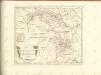


Montisferrati Ducatus. [Karte], in: Novus Atlas, das ist, Weltbeschreibung, Bd. 3, S. 54.
1 Karte aus Atlas Blaeu, Joan Blaeu, Willem Janszoon
Status Reipublicae Genuensis
1 : 600000 Mollova mapová sbírka Homann, Johann Baptist Homann, Johann Baptista - dědici
Republicae Genuensis Dominium
1 : 600000 Mollova mapová sbírka Seutter, Matthäus Seutter, Matthäus
Riviera Di Genova Di Ponente [Karte], in: Novus atlas absolutissimus, Bd. 5, S. 99.
1 Karte aus Atlas Janssonius Offizin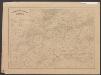
Riviera Di Genova Da Ponente [Karte], in: Le théâtre du monde, ou, Nouvel atlas contenant les chartes et descriptions de tous les païs de la terre, Bd. 3, S. 48.
1 Karte aus Atlas Blaeu, Willem Janszoon und Blaeu, Joan Blaeu, Willem Janszoon
Montisferrati Ducatus. [Karte], in: Theatrum orbis terrarum, sive, Atlas novus, Bd. 3, S. 46.
1 Karte aus Atlas Blaeu, Joan Blaeu, Willem Janszoon

MONTISFERRATI | DVCATVS
Amstelodami, excudit Iudocus Hondius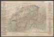
Montisferrati Ducatus. [Karte], in: Le théâtre du monde, ou, Nouvel atlas contenant les chartes et descriptions de tous les païs de la terre, Bd. 3, S. 39.
1 Karte aus Atlas Blaeu, Willem Janszoon und Blaeu, Joan Blaeu, Willem Janszoon
Nouvelle carte de l'etat de la republique de Genes
1 : 617000 Bastia (Francie) Ottens, Josua R. et I. Ottens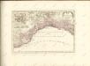
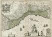
La Republique de Genes.
1 : 610000 Mollova mapová sbírka Blaeu, Willem Janszoon Covens, Johannes I


