Maps of Thonon-les-Bains
Description du lac de Geneue
1 Karte : Kupferdruck ; 11 x 15 cm Sebastian Cramoisy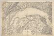
Lac Léman : carte au 1:100.000e : report sur pierre d'une partie des feuilles XI, XII, XVI, XVII de la Carte Dufour
1 : 100000 [S.l. : Bureau topographique fédéral]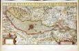
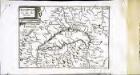
Chorographica tabula lacus Lemanni locorumqve circumiacentium
1 Karte : Kupferdruck ; 29 x 54 cm Mercator; Hondius; Goulart Henricus Hondius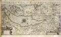
Chorographica tabula lacus Lemanni locorumqve circumiacentium
1 Karte : Kupferdruck ; 29 x 54 cm Mercator; Hondius; Goulart Jodocus Hondius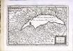
Lac Leman
1 Karte : Kupferdruck ; 13 x 19 cm s.n.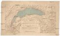
Compagnie Générale de Navigation sur le lac Léman
Labarthe, E. Compagnie générale de navigation sur le lac Léman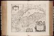
Lacvs Lemanni locorvmqve circvmiacentivm accvratissima descriptio / auctore Iacobo Govlartio Genevensi
1 : 135000 Annotatie: In cartouche: Benevole lector, F. Franciam G. Genevam denotat; Origineel is Blad 118 in atlas factice; Annotatie geografische gegevens: Drie schaalstokken op de kaart: Scala milliarium Germanicorum, Scala milliarium Sabaudicorum, en: Scala milliarium Gallicorum Jacques Goulart 1580-; Johannes Janssonius 1588-1664 Amstelodami : apud Ioannem Ianßonium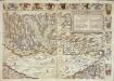
Inclitae Bernatum urbis, cum omni ditionis suae agro et provinciis delineatio chorographica, 5/6
2 Blätter : Adelbert Saueracher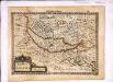
Lacus Lemannus
1 Karte : Kupferdruck ; 17 x 24 cm Mercator Cloppenburgh
Lacvs Lemanni Locorvmqve Circvmiacentivm Accvratissima descriptio
1 : 160000 Mollova mapová sbírka Goulart, Jacques Schenk, Peter I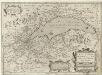
Lacvs Lemani Vicinorvmq. Locorvm Nova et Accvrata descriptio
1 : 180000 Mollova mapová sbírka Picart, Hugues Le Clerc, Jean
Lacvs Lemanni locorvmqve circvmiacentivm accvratissima descriptio
1 Karte : Kupferdruck ; 41 x 53 cm Goulart; Blaeu apud Guiljelmum Blaeu
Lacvs Lemani vicinorvmq. locorvm nova et accvrata descriptio
1 Karte : Kupferdruck ; 35 x 47 cm Hondius Judocus Hondius excudit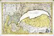
Dvcatvs Chablasivs et lacvs Lemanvs
1 Karte : Kupferdruck ; 36 x 58 cm Blaeu; Borgonio; Broen; Ottens; Ottens invenitur apud R. et I. Ottens geographos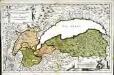
Dvcatvs Chablasivs et lacvs Lemanvs
1 Karte : Kupferdruck ; 36 x 58 cm Blaeu; Borgonio; Broen Joannes Blaeu excudit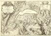
Carte du Lac de Geneve et des Pays Circonvoisins
1 : 150000 Mollova mapová sbírka Chopy, Antoine Daudet, Jean-Louis Chopy, Antoine
Lacvs Lemani Vicinorvmq. Locorvm Nova Et Accvrata Descriptio
1 : 180000 Mollova mapová sbírka Hondius, Jodocus Hondius, Jodocus II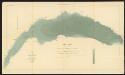
Lac Léman
1 : 50000 Hörnlimann, J. ; Lochmann, Jean Jacques ; Magnin, J. Ministère des Travaux Publics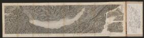
[Malerisches Relief der Schweizer- und angränzenden Alpen]
Delkeskamp, Friedrich Wilhelm F.W. Delkeskamp
Blatt XVI: Genève, Lausanne, uit: Topographische Karte der Schweiz / vermessen und hrsg. ... unter Aufsicht des Generals G.H. Dufour
1 : 100000 Annotatie: Met plaatsnamenregister (bl. V), bladwijzer (bl. XXI) en hoogteregister (bl. XXV); Voor aanwezige bladen zie overzichtsblad Dufour, G. H. [Bern : Eidg. Topogr. Bureau]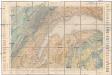
Carte géologique de la Suisse
1 : 100000 Lausanne (Švýcarsko) Schardt, H. Lugeon, M.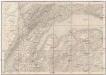
Geneve, Lausanne
1 : 100000 Lausanne (Švýcarsko)
Topographische Karte der Schweiz
1 : 100000 25 Karten vermessen und hrsg. auf Befehl der Eidgenössischen Behörden ; aufgenommen unter der Aufsicht des Generals G.H. Dufour Eidg. Topographisches Bureau, [Genève], [später: Bern]
Genève, Lausanne
1 : 100000 1 Karte par Aug. Jaccard [Wurster & Randegger], [Winterthur]
Vero dissegno del lago di Geneva con i lvoghi chel circondano
1 : 200000 Bertelli, Luca Franco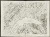
Plus grande partie de la Suisse romande ou canton du Léman
1 : 108000 Weiss, Johann Heinrich ; Guérin, Christophe ; Meyer, Johann Rudolf J. R. Meyer
Carte de la Suisse romande, 3
1 Blatt : s.n.
Carte de la Suisse romande, 3
1 Blatt : s.n.
Atlas der Schweiz
1 : 450000 1 Atlas (18 Bl.) gez. u. gest. v. J. Scheurmann Orell Fussli, Zurich


