Maps of Jura
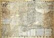
Inclitæ Bernatvm vrbis, cvm omni ditionis svæ agro et provinciis delineatio chorographica
1 Karte auf 18 Blatt : Kupferdruck ; 128 x 187 cm Schöpf; Martin; Krumm; Jobin; Saueracher; Meyer Albrecht Meyer
Inclitæ Bernatvm vrbis, cvm omni ditionis svæ agro et provinciis delineatio chorographica
1 Karte auf 18 Blatt : Kupferdruck ; je 46 x 65 cm Schöpf; Martin; Krumm; Jobin; Saueracher Adelbert Saueracher
Mappa geographica illustris Helvetiorum reipublicæ Bernensis
1 Karte : Kupferdruck ; 47 x 55 cm Seutter; Lotter; Seutter Matthäus Seutter
Canton Bern sive illustris Helvetiorum respvblica Bernensis
1 Karte : Kupferdruck ; 45 x 55 cm Walser; Dorn edentibus Hommanianis Heredibus
Canton Bern sive illustris Helvetiorum respvblica Bernensis
1 Karte : Kupferdruck ; 46 x 55 cm Walser; Dorn edentibus Hommanianis Heredibus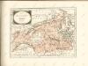

Atlas der alten Eidgenossenschaft in 20 Karten: Kanton Bern
Originaltitel: Canton Bern sive Illustris Helvetiorum Respublica Bernensis cum Subditis suis et Confinibus. Zeichnung: Walser, Gabriel (1695-1776), reformierter Pfarrer, von Teufen AR Herausgeber: Homännische Erben
Canton Bern sive Illustris Helvetiorum Respvblica Bernensis cum Subditis suis et Confinibus recenter delineata
1 : 430000 Mollova mapová sbírka Walser, Gabriel Dorn, Sebastian Homann, Johann Baptista - dědici
Mappa Geographica illustris Helvetiorum Republicae Bernensis cum adjacentibus pagorum et dynastiarum confiniis accurate delineata
1 : 460000 Mollova mapová sbírka Seutter, Matthäus Seutter, Albrecht Carl Seutter, Matthäus
Mappa Geographica illustris Helvetiorum Republicae Bernensis cum adjacentibus pagorum et dynastiarum confiniis accurate delineata
1 : 460000 Mollova mapová sbírka Seutter, Matthäus Seutter, Albrecht Carl Seutter, Matthäus
Karte des Kriegs-Schauplatzes der Schweiz
1 : 700000 2 Karten Verlag der Steiner'schen Buchhandlung, [Winterthur]
Canton Bern sive illustris helvetiorum respublica Bernensis
1 Karte : Kupferdruck ; 24 x 26 cm Walser Homännische Erben
Touristen-Karte der Schweiz
1 : 400000 Evropa Imfeld, X. Jura–Simplon-Bahn
24) IX.N.E. ''Berne'', uit: Carte géologique de France
1 : 500000 Annotatie: Voor aanwezige bladen zie bladoverzicht [S.l : s.n.]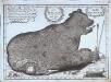
Nova ditionis Bernensis tabula geographica ursi effigie delineata
1 Karte : Kupferdruck ; 23 x 33 cm Störcklein s.n.
Nova ditionis Bernensis tabula geographica ursi effigie delineata
1 Manuskriptkarte : 23 x 33 cm Störcklein s.n.
Carte du réseau télégraphique Suisse
1 : 250000 Westblatt Schweizerische Telegraphen- und Telephonverwaltung Kartographische Anstalt LIPS
Carte du réseau téléphonique suisse
1 : 250000 Westblatt Schweizerische Telegraphen- und Telephonverwaltung H. & A. Kümmerly & Frey
[Fribourg, Solothurn]
1 : 1450000 [Stumme Kartenskizzen der ganzen Schweiz und der einzelnen Kantone zu Unterrichtszwecken] Schulbuchhandlung Antenen
[Exactissima Helvetiae, Rhaetiae, Valesiae ... tabula]
1 : 850000 9 Karten [Kopie von Adrian Braakman] [chez Pierre Schenk et Adrian Braakman], [Amsterdam]
Carte des Cantons Bern
1 : 190000 Durheim, Karl C. Durheim
Carte de Suisse suivant sa nouvelle division en XVIII cantons formant la République Helvétique, 1
1 Blatt : chez F. Monty
<<Der>> Canton Bern
1 : 390000 1 Karte gez. u. gest. v. J. Scheuermann Orell Füssli & Comp., Züric [i.e. Zürich]
Karte des Cantons Bern
1 : 200000 Kutter, Wilhelm Rudolf ; Leuzinger, Rudolf J. Dalp'sche Buch- und Kunsthandlung (Karl Schmid)
<<Der>> Canton Freyburg
1 : 270000 1 Karte gez. u. gest. von J.J. Scheurmann [Orell Füssli & Cp.], [Zürich]
<<Das>> Wiflispurgergow
1 : 500000 1 Karte [von Johannes Stumpf] [Christoph Froschauer oder Johann Wolf], [Zürich]
Carte des Kantons Bern
1 : 400000 1 Karte Topogr. Anstalt von Wurster, Randegger & Co in Winterthur Schulbuchhandlung Antenen, Bern
Carte archéologique du Canton de Berne
1 : 200000 Bonstetten, Gustav Karl <
Nova Helvetiae tabula geographica
1 : 1000000 Nordwest-Blatt Scheuchzer, Johann Jakob ; Schenck, Peter ex officina Petri Schenckii


