Maps of District de l'Ouest lausannois
Carte topographique de la grande route de Berne à Genève, Blatt 10-12
3 Blätter : 35 x 48 cm Ochs
[Kaart + gids, p. 4], uit: Plan de Lausanne
1 : 8000 Annotatie: Verso: toeristische informatie; In omslag: straatnamenregister; Annotatie geografische gegevens: Inzet: Panorama du Signal Lausanne : Simplon
Plan de la ville de Lausanne et de sa banlieue
1 : 8000 1 Plan Etabl. topogr. de Wurster, Randegger & Co. D. Lebet, éditeur, [Erscheinungsort nicht ermittelbar]
Plan de Lausanne et de sa banlieue
1 : 8000 1 Plan Etabl. topogr. de Wurster, Randegger & Co. F. Payot, Lausanne
Plan de la ville de Lausanne et de sa banlieue
1 : 5000 Furrer, H. Lebet, D. Lith. H. Furrer
Carte de Lausanne et ses environs
1 : 16300 [s.n.]
Lausanne
1 : 100000 [s.n.]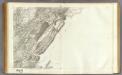
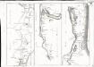
147 Nozeroy, Les Rousses.
1 : 86400 Cassini family; Cassini, Cesar-Francois, 1714-1784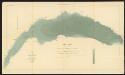
Lac Léman
1 : 50000 Hörnlimann, J. ; Lochmann, Jean Jacques ; Magnin, J. Ministère des Travaux Publics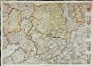
Inclitae Bernatum urbis, cum omni ditionis suae agro et provinciis delineatio chorographica, 11/12
2 Blätter : Adelbert Saueracher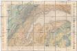
Carte géologique de la Suisse
1 : 100000 Lausanne (Švýcarsko) Schardt, H. Lugeon, M.
Blatt XVI: Genève, Lausanne, uit: Topographische Karte der Schweiz / vermessen und hrsg. ... unter Aufsicht des Generals G.H. Dufour
1 : 100000 Annotatie: Met plaatsnamenregister (bl. V), bladwijzer (bl. XXI) en hoogteregister (bl. XXV); Voor aanwezige bladen zie overzichtsblad Dufour, G. H. [Bern : Eidg. Topogr. Bureau]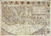
Inclitae Bernatum urbis, cum omni ditionis suae agro et provinciis delineatio chorographica, 5/6
2 Blätter : Adelbert Saueracher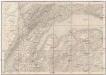
Geneve, Lausanne
1 : 100000 Lausanne (Švýcarsko)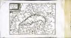
Description du lac de Geneue
1 Karte : Kupferdruck ; 11 x 15 cm Sebastian Cramoisy
[Nozeroy - les Rousses]
1 Blatt : 59 x 90 cm s.n.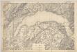
Lac Léman : carte au 1:100.000e : report sur pierre d'une partie des feuilles XI, XII, XVI, XVII de la Carte Dufour
1 : 100000 [S.l. : Bureau topographique fédéral]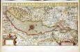
Chorographica tabula lacus Lemanni locorumqve circumiacentium
1 Karte : Kupferdruck ; 29 x 54 cm Mercator; Hondius; Goulart Henricus Hondius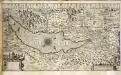
Chorographica tabula lacus Lemanni locorumqve circumiacentium
1 Karte : Kupferdruck ; 29 x 54 cm Mercator; Hondius; Goulart Jodocus Hondius
Topographische Karte der Schweiz
1 : 100000 25 Karten vermessen und hrsg. auf Befehl der Eidgenössischen Behörden ; aufgenommen unter der Aufsicht des Generals G.H. Dufour Eidg. Topographisches Bureau, [Genève], [später: Bern]
Topographische Karte der Schweiz
1 : 100000 25 Karten vermessen und hrsg. auf Befehl der Eidgenössischen Behörden ; aufgenommen unter der Aufsicht des Generals G.H. Dufour Eidg. Topographisches Bureau, [Genève], [später: Bern]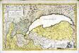
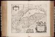
Dvcatvs Chablasivs et lacvs Lemanvs
1 Karte : Kupferdruck ; 36 x 58 cm Blaeu; Borgonio; Broen; Ottens; Ottens invenitur apud R. et I. Ottens geographos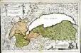
Dvcatvs Chablasivs et lacvs Lemanvs
1 Karte : Kupferdruck ; 36 x 58 cm Blaeu; Borgonio; Broen Joannes Blaeu excudit
Plus grande partie de la Suisse romande ou canton du Léman
1 : 108000 Weiss, Johann Heinrich ; Guérin, Christophe ; Meyer, Johann Rudolf J. R. Meyer
Pontarlier, Yverdon
1 : 100000 1 Karte par Aug. Jaccard [Wurster & Randegger], [Winterthur]
Genève, Lausanne
1 : 100000 1 Karte par Aug. Jaccard [Wurster & Randegger], [Winterthur]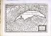
Lac Leman
1 Karte : Kupferdruck ; 13 x 19 cm s.n.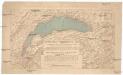
Compagnie Générale de Navigation sur le lac Léman
Labarthe, E. Compagnie générale de navigation sur le lac Léman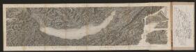
[Malerisches Relief der Schweizer- und angränzenden Alpen]
Delkeskamp, Friedrich Wilhelm F.W. Delkeskamp