Maps of District de la Broye-Vully

Carte de la Suisse romande, 2
1 Blatt : s.n.
Carte de la souveraineté de Neufchatel et Valangin
1 Karte : Kupferdruck ; 40 x 57 cm L'Isle; Merveilleux Homännische Erben
Carte du canton de Neuchâtel
1 : 100000 1 Karte dessinée et gravée par E. Wagner Delachaux et Niestlé, Neuchâtel
Carte des comtés de Neuchatel et de Vallangin
1 Karte : Kupferdruck ; 31 x 43 cm Clermont; Merveilleux; Perrier; Beauvais; Arrivet Lamy
Carte De La Souveraineté de Neuchatel et Vallangin
1 : 100000 Mollova mapová sbírka Seutter, Albrecht Carl Seutter, Albrecht Carl
Carte de la principauté de Neuchatel
1 : 10000 Neuchâtel (Švýcarsko : kanton) d'Ostervald, J. F. Berthier, Louis Alexandre
Carte de la principauté de Neuchâtel
1 : 95000 Ostervald, Jean-Frédéric d' ; Aubert, J.B.L. Ch. Picquet
Carte de la souveraineté de Neuchatel et Vallangin
1 Karte : Kupferdruck ; 47 x 58 cm Seutter; Probst anjezo in Verlag bey Iohann Michael Probst chalcogr
Carte de la souveraineté de Neuchatel et Vallangin
1 Karte : Kupferdruck ; 46 x 63 cm L'Isle; Merveilleux; Liébaux; Buache Philippe Buache
Carte de la souveraineté de Neuchatel et Vallangin
1 Karte : Kupferdruck ; 46 x 63 cm L'Isle; Merveilleux; Liébaux Guillaume Delisle
Carte topographique du canton de Fribourg
1 : 50000 Nordwest-Blatt Stryienski, Alexandre ; Delsol, Théodore ; Hacq, J.M. ; Carré, ... F. Chardon ainé
Topographische Karte des Kantons Freiburg: Blatt 4
1 : 50000 Mit Legende der verwendeten Zeichen. Stryienski, Casimir Napoléon Alexandre (1804-1875), Ingenieur, von Polen Kupferstich: Delsol, Théodore (1819-1870), von Frankreich; Hacq, J. M.; Carré. V.
<<Le>> canton de Neuchâtel
1 : 200000 1 Karte dessiné et gravé d'après la carte de Mr. d'Ostervald par G. Hegi [Orell Füssli & Comp.], [Zürich]
<<Le>> canton de Neuchâtel
1 : 200000 1 Karte dessiné et gravé d'après la carte de Mr. d'Ostervald par G. Hegi [Orell Füssli & Comp.?], [Zürich?]
<<Le>> canton de Neuchâtel
1 : 200000 1 Karte dessiné et gravé d'après la carte de Mr. d'Ostervald par G. Hegi [Orell Füssli & Comp.], [Zürich]
Atlas der Schweiz
1 : 450000 1 Atlas (18 Bl.) gez. u. gest. v. J. Scheurmann Orell Fussli, Zurich

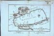
Plan de la bataille de Granson [i.e. Grandson]
1 : 50000 1 Karte composé & dessiné par Frédéric Dubois ; F. Hegi sc. [Antiquarische Gesellschaft], [Zürich]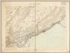
Neuchâtel et environs
1 : 25000 Annotatie: Report sur pièrre 1896; Annotatie geografische gegevens: Met schaalstok: kilometer Bureau Topographique Fédéral, Berne Berne : Bureau Topographique Fédéral / (Berne : Kümmerly, frès)
Grundriss von dem Murten-See
1 : 50000 1 Karte des. pr Vissaula Herrliberger, Zürich
Schlacht bey Granson [i.e. Grandson] am 2. März 1476
1 : 75000 1 Karte Müllhaupt sculps. [Feuerwerker-Gesellschaft], [Zürich]
<<Das>> Schlachtfeld von Murten 1476
1 : 50000 1 Karte de Mandrot [Feuerwerker-Gesellschaft], [Zürich]
[Le desséchement de la Plaine de l'Orbe]
1 : 50000 Gonin, Louis Imprimerie Georges Bridel
Plan der Umgebungen von Freyburg
1 : 50000 1 Karte [Kartogr.:] Topogr. Anstalt v. J. Wurster u. Comp. [Stämpflische Verlagshandlung], [Bern]
Plan der Umgebungen von Freyburg
1 : 50000 1 Karte Topogr. Anstalt v. J. Wurster u. Comp. [Friedrich Schulthess], [Zürich]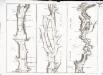
Carte topographique de la grande route de Berne à Genève, Blatt 7-9
3 Blätter : 35 x 48 cm Ochs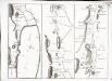
Carte topographique de la grande route de Berne à Genève, Blatt 4-6
3 Blätter : 35 x 48 cm Ochs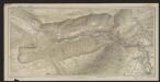
Carte des gorges de l'Areuse
1 : 15000 Borel, Maurice Imprimerie F. Gendre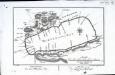
Grundriss, von dem Murten=See
1 Karte : Kupferdruck ; 16 x 25 cm Herrliberger; Vissaula D. Herrliberger exc