Maps of Zuid-Holland

Charte von Holland
1 Karte : Kupferdruck ; 55 x 43 cm Güssefeld by den Hom. Erben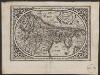
Comitatus Hollandia
1 : 1200000 [Abraham Goos engraver] [Amsterdam etc.] : [Abraham Goos etc.]
Hollandia
1 : 950000 [Jodocus Hondius sr. engraver] [Amsterdam etc.] : [Jodocus Hondius sr. etc.]
Hollandia
1 : 950000 [Jodocus Hondius sr. engraver] [Amsterdam etc.] : [Jodocus Hondius sr. etc.]
Hollandiae cattorum regionis typus
1 : 550000 [Lodovico Guicciardini] [Antwerpen] : [Christoffel Plantijn]
Hollandia Comitatus
1 : 990000 [Pieter van den Keere engraver] [Amsterdam] : Johannes Janssonius]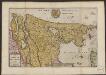
Le Comte de Hollande
1 : 750000 auctore Baltha: Florentius de Berkenrode. [Amsterdam] : La Feuille exc.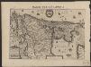
Comitatus Hollandiae novissima descriptio
1 : 760000 designatore Balth. Flor. a Berckenr. Amstelodami : sumptibus Henrici Hondii.

HOLLANDIA | COMITATVS
Apud Guiljelmum Blaeu
Comitatus Hollandiae tabula
1 : 300000 pluribus locis recens emendata a Frederico de Wit. [Amsterdam] : ex officina I. C
Hollandia
1 : 1500000 [Jodocus Hondius jr. engraver] [Amsterdam] : [Jodocus Hondius jr.]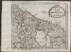
Les provinces de la Hollande et d'Utrecht
1 : 800000 [Anthoni de Winter] [Amsterdam] : [François Halma]
Comitatus Hollandiæ tabula pluribus locis recens
1 : 300000 pluribus locis recens emendata a Frederico de Wit. Gedruckt 't Amsterdam : by Frederick de Wit ...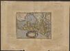
Hollandiæ comitatus Hollant grafschaftt
1 : 1000000 [Frans Hogenberg] [Keulen] : [s.n.]
La Hollande suivant les nouvelles observations de messrs. de l'Academie Royale des Sciences, etc. augmentées de nouveau
1 : 900000 [Pieter van der Aa] A Leide : chez Pierre van der Aa
Le Comte de Hollande
1 : 750000 auctore Baltha: Florentius de Berkenrode. [Amsterdam] : [Jacob Aertsz. Colom]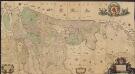
Comitatus Hollandiæ et Dominii Ultraiectini tabula
1 : 60000 [Jacob Aertsz. Colom] Amstelodami : ex officina I. Côvens et C. Mortier vulgo de Vygendam
Les provinces de Hollande et d'Utrecht
1 : 800000 [Georges-Louis Le Rouge] [Paris] : G. Le Rouge

Comitatus Hollandiæ tabula pluribus locis recens
1 : 300000 pluribus locis recens emendata a Nicolao Visscher. [Amsterdam] : nunc apud Petrum Schenk junior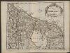
De provintien van Hollandt en Utrecht
1 : 800000 [Anthoni de Winter] [Amsterdam] : [François Halma]
Holland
1 : 440000 [François Halma] [Leeuwarden] : [Henrik Halma]
Comitatus Hollandiae tabula
1 : 300000 pluribus locis recens emendata a Nicolao Visscher. [Amsterdam : Nicolaus Visscher]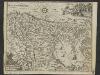
Condado de Olanda
1 : 1000000 [Jacques Harrewijn] [Madrid] : [Francisco Laso]
Hollandia Comitatus
1 : 520000 [Caspar Merian] [Frankfurt am Main] : Caspar Merian]
Charte von Holland
1 : 300000 nach astronomischen Beobachtungen, den Messungen des Schnellius &.c.c. und den vorzüglichsten Specialcharten neu entworfen von F.L. Güssefeld. Nürnberg : bey den Hom[ännischen Erben]
Comitatus Hollandiæ tabula pluribus locis recens
1 : 320000 pluribus locis recens emendata a Justo Danckerts. [Amsterdam] : Justus Danckerts
Comitatus Hollandiae tabula / pluribus locis recens emendata a Nicolao I. Visschero
1 : 300000 Annotatie: Origineel is Blad 50 in atlas factice; Annotatie geografische gegevens: West boven Visscher, Claes Jansz. [Amsterdam : C.J. Visscher excudit]


