Maps of Thann-Guebwiller

Le cours du Rhin de Bâle à Hert près Philisbourg contenant l'Alsace et partie du Brisgau, 2
1 Blatt : 75 x 52 cm Le Rouge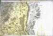
[Neuf-Brisach]
1 Blatt : 61 x 90 cm s.n.
Le Flambeau de la Guerre Allumee au Rhin
Mollova mapová sbírka Delisle, Guillaume Schenk, Peter II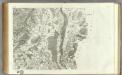
164 Neuf-Brisach.
1 : 86400 Cassini family; Cassini, Cesar-Francois, 1714-1784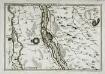
Les environs des deux Brisachs
1 Karte : Kupferdruck ; 23 x 33 cm Fer; Inselin Nicolas de Fer
Le Flambeau de la Guerre Allumee au Rhin
Mollova mapová sbírka Delisle, Guillaume Schenk, Peter II
Nieuwe en naukeurige aftekening van Freiburg met alle zyne sterktens en omleggende landen etc
1 Karte : Kupferdruck ; 43 x 55 cm Ottens; Ottens chez R. et I. Ottens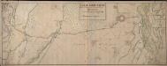
Carte Particuliere De la Situation de Vieux et Neuf Brisack et du Canal de Roussack

Nouvelles plans et environs du vieux et du neuf Brisac
1 Karte : Kupferdruck ; 43 x 55 cm Ottens; Ottens chez R. et I. Ottens
Les environs du vieux Brisac la position de l'isle de Rheinach
1 Karte : Kupferdruck ; 46 x 55 cm Le Rouge Georges Louis Le Rouge rue des grands Augustins vis à vis le Panier Fleury

Geologische Karte der Umgebungen der Bäder Glotterthal und Suggenthal
1 : 50000 Schill, Julius Chr. Fr. Müller'sche Hofbuchhandlung
Topographische - Carte des Rheinstromes und seiner beiderseitigen Ufer von Hüningen bis Lauterburg...

Meßtischblatt [8112] : Staufen (Belchen), 1928
1 : 250000 Staufen (Belchen). - 1:25000. - Karlsruhe: Kunstdr. Künstlerbund, 1928. - 1 Kt.
Meßtischblatt 3679 : Rumersheim,1886
1 : 250000 Rumersheim. - Aufn. 1885. - 1:25000. - [Berlin]: Reichsamt für Landesaufnahme, 1886. - 1 Kt.
Meßtischblatt 3678 : Ensisheim, 1886
1 : 250000 Ensisheim. - Aufn. 1885. - 1:25000. - [Berlin]: Reichsamt für Landesaufnahme, 1886. - 1 Kt.
Meßtischblatt 3677 : Sennheim, 1887
1 : 250000 Sennheim. - Aufn. 1885. - 1:25000. - [Berlin]: Reichsamt für Landesaufnahme, 1887. - 1 Kt.
Meßtischblatt 3676 : Thann, 1897
1 : 250000 Thann. - Aufn. 1895. - 1:25000. - [Berlin]: Reichsamt für Landesaufnahme, 1897. - 1 Kt.
Meßtischblatt 116 : Ehrenstetten, 1930
1 : 250000 Ehrenstetten. - Berichtigt 1893, wichtigere Nachtr. 1930. - 1878 [erschienen ca. 1930].. - 1:25000. - Karlsruhe : Kunstdr. Künstlerbund, 1930. - 1 Kt.
Meßtischblatt [8011] : Hartheim, 1878
1 : 250000 Hartheim. - 1:25000. - Leipzig: Giesecke & Devrient, 1878. - 1 Kt.
Meßtischblatt 3669 : Gebweiler, 1886
1 : 250000 Gebweiler. - Aufn. 1884. - 1:25000. - [Berlin]: Reichsamt für Landesaufnahme, 1886. - 1 Kt.
Meßtischblatt 3668 : Lautenbach, 1886
1 : 250000 Lautenbach. - Aufn. 1884. - 1:25000. - [Berlin]: Reichsamt für Landesaufnahme, 1886. - 1 Kt.
Meßtischblatt [7912] : Eichstetten, 1878
1 : 250000 Eichstetten. - 1:25000. - Leipzig: Giesecke & Devrient, 1878. - 1 Kt.
Meßtischblatt Breisach (Alt)
1 : 250000 Breisach (Alt). - Hrsg. 1878, bericht. 1889, wichtigere Nachtr. bis 1926. - 1:25000. - Leipzig: Giesecke & Devrient, 1926. - 1 Kt.
Meßtischblatt 3663 : Neubreisach, 1885
1 : 250000 Neubreisach. - Aufn. 1884. - 1:25000. - [Berlin]: Reichsamt für Landesaufnahme, 1885. - 1 Kt.
Meßtischblatt Breisach (Alt)
1 : 250000 Breisach (Alt). - 1:25000. - Leipzig: Giesecke & Devrient, 1878. - 1 Kt.
Meßtischblatt 3662 : Colmar, 1886
1 : 250000 Colmar. - Aufn. 1884. - 1:25000. - [Berlin]: Reichsamt für Landesaufnahme, 1886. - 1 Kt.
Meßtischblatt 3660 : Münster (Im Elsass), 1886
1 : 250000 Münster (Im Elsass). - Aufn. 1884. - 1:25000. - [Berlin]: Reichsamt für Landesaufnahme, 1886. - 1 Kt.
Blatt 5. Hartheim, uit: Topographische Karte des Rheinstromes und seiner beiderseitigen Ufer von Hueningen bis Lauterburg oder längs der Französich-Badischen Gränze, ... / ... reducirt und gezeichnet ... im Bureau der Grossherzoglich Badischen Rheingränz-Berichtigungs Commission
1 : 20000 titelvariant: Rheingränz-Carte; Annotatie: Voor aanwezige bladen zie overzichtsblad Grossherzogliche Badische Rheingränz-Berichtigungs Commission. Bureau Freiburg im Breisgau : im Herder'schen Künst-Institut


