Maps of Haut-Rhin

Alasatia superior et inferior III. tabulis delineata, 1
1 Blatt : 62 x 62 cm s.n.
Departement du Haut Rhin
1 Karte : Kupferdruck ; 16 x 14 cm au dépot de l'Atlas national rue de la Monnoye no. 5
Partie de la Haute Alsace le Suntgaw, et le Brisgaw Partie du Canton de Basle et du Cours du Rhein ou sont les Valles de Brisac Fribourg, Colmars Huningue Befort et Basle
1 : 160000 Mollova mapová sbírka Baillieul, Gaspard Bailleul, Gaspard
Département du Haut Rhin
1 Karte : Kupferdruck ; 48 x 48 cm Houdan au bureau de l'atlas national rue de la Harpe no. 26, et au depôt de cet atlas rue de la Monnoye no. 5
Part Septentr. de l'Evesché de Basle et Partie de l'Eveché de Constance. Haute Alsace, Sungow, Brisgow &c.
1 : 240000 Mollova mapová sbírka Sanson, Nicolas Lalleman, N. Sanson, Nicolas
Territory Basiliensis Nova Descriptio
1 : 21000 Mollova mapová sbírka Janssonius, Johannes Janssonius, Johannes I
Le Theatre de Bellone :
Mollova mapová sbírka Schenk, Pieter Braakman, Adriaan
Alsatia tem Svperior, quam Inferior una cum Svndgovia
1 : 120000 Mollova mapová sbírka Homann, Johann Baptist Homann, Johann Baptista - dědici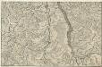
Le Cours du Rhein, depuis Spire jusqu'a Mayence
1 : 180000 Mollova mapová sbírka Fer, Nicolas de Starckman, P. Fer, Nicolas de
Freiburg
1 : 200000 Herder, Bartholomew
Sequani Latobrigi
1 Karte : Kupferdruck ; 40 x 43 cm Sanson; Robert de Vaugondy; Laleman chés le Sr. Robert geog. du roi quai de l'horloge du Palais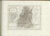

La Haute Alsace, le Suntgow et le Brisgow
1 Blatt : 52 x 38 cm de Fer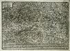
Elsatia svperior
1 Karte : Kupferdruck ; 17 x 27 cm Quad Johannes Bussemacher
Sequani Latobrigi
1 Karte : Kupferdruck ; 40 x 43 cm Sanson; Robert de Vaugondy; Laleman chés le Sr. Robert geog. du roi quai de l'horloge du Palais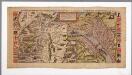
Die loeblig und wijt berümpt Statt Basel mit umbligender Landschafft nach warer geographischer art beschriben / durch Sebastianus Munster
1 : 4800 Annotatie: Facs. van de uitg.: 1538; Annotatie geografische gegevens: Zuid boven Sebastian Münster 1489-1552 Basel : Frobenius
Le Theatre de la Guerre Sur le Haut Rhein
1 : 142000 Mollova mapová sbírka Sanson, Guillaume
Territory Basiliensis nova descriptio
1 Karte : Kupferdruck ; 37 x 48 cm Janssonius; Keere Ioannes Ianssonius excudit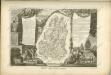

Belfort, Basel
1 : 100000 1 Karte par Aug. Jaccard et Alb. Muller [i.e. Müller] [Wurster & Randegger], [Winterthur]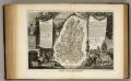
Dept. Du Haut Rhin.
1 : 571000 Levasseur, Victor.
Topographische Karte der Schweiz
1 : 100000 25 Karten vermessen und hrsg. auf Befehl der Eidgenössischen Behörden ; aufgenommen unter der Aufsicht des Generals G.H. Dufour Eidg. Topographisches Bureau, [Genève], [später: Bern]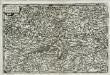
Alsatia svperior
1 Karte : Kupferdruck ; 14 x 22 cm Lambert Andreae
Atlas Suisse
1 : 120000 16 Karten levé et dessiné par J.H. Weiss [et Joachim Eugen Müller] aux frais de J.R. Meyer à Aarau dans les années 1786 à 1802 ; gravée [sic] par [Christophe] Guérin, [Matthias Gottfried] Eichler et [Johann Jakob] Scheurmann [Johann Rudolf Meyer], Aarau
Basiliensis territorii descriptio nova
1 Karte : Kupferdruck ; 31 x 23 cm Münster; Ortelius s.n.
Basiliensis territorii descriptio nova
1 Karte : Kupferdruck ; 31 x 23 cm Münster; Ortelius s.n.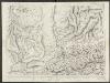
Le Canton de Basle, et parties des cantons d'Argauvie et Soleure du Frikthal et frontières
1 : 108000 Weiss, Johann Heinrich ; Scheuermann, Johann Jakob ; Meyer, Johann Rudolf J. R. Meyer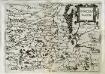
Svnggoia
1 Karte : Kupferdruck ; 15 x 20 cm Lambert Andreae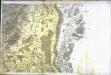
[Neuf-Brisach]
1 Blatt : 61 x 90 cm s.n.


