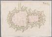
Maps of Commercy
Le Toulois
1 Karte : Kupferdruck ; 43 x 68 cm Jaillot Alexis-Hubert Jaillot
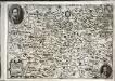
Archidia.connés De Tovl, De Ligny, et Reynel, Dans l'Evesché De Tovl
1 : 240000 Mollova mapová sbírka Sanson, Nicolas Somer, Jean Pruthenus Sanson, Nicolas
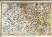
Leuci
1 Karte : Kupferdruck ; 41 x 48 cm Sanson; Robert de Vaugondy; Somer chés le Sr. Robert geographe ord. du roi quai de l'horloge
Bar le Duc 125, uit: Special-Karte von Mittel-Europa / nach amtlichen Quellen bearbeitet von W. Liebenow
1 : 300000 titelvariant: W. Liebenow's Mittel-Europa; Annotatie: Titel boven de bladen: W. Liebenow's Mittel-Europa Johannes Wilhelm Liebenow 1822-1897 Frankfurt a. M. : Ludwig Ravenstein
Bar le Duc 125, uit: [W. Liebenow's Special-Karte von Mittel-Europa]
1 : 300000 titelvariant: W. Liebenow's Mittel-Europa; Annotatie: Titel boven de bladen: W. Liebenow's Mittel-Europa Johannes Wilhelm Liebenow 1822-1897 Hannover : Hermann Oppermann
Leuci
1 Karte : Kupferdruck ; 41 x 48 cm Sanson; Somer chez l'autheur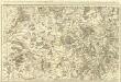
Le Toulois ou sont Les Catellenies et Les Prevotés du Temporel del'Eveché de Toul et deson Chapitre :
1 : 180000 Mollova mapová sbírka Jaillot, Alexis-Hubert Jaillot, Alexis Hubert
No. 111 (41) [Bar-le-Duc, Commercy, Toul], uit: Carte géométrique de la France dite "Carte de Cassini" ou "de l'Académie"
1 : 86400 titelvariant: Carte de Cassini; Annotatie: Incompleet; Voor aanwezige bladen zie overzichtsblad Cassini de Thury, C.-F. Paris : [s.n.]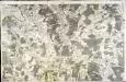
[Verdun]
1 Blatt : 60 x 91 cm Seguin s.n.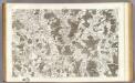
111 Toul.
1 : 86400 Cassini family; Cassini, Cesar-Francois, 1714-1784
167. Solgne, uit: Topographische Uebersichtskarte des Deutschen Reiches / herausgegeben v. d. Kartogr. Abt. d. Königl. Preuß. Landesaufnahme
1 : 200000 titelvariant: Topogr. Übersichtskarte des Deutschen Reiches; Annotatie: Titel boven bladen ook: Topogr. Übersichtskarte des Deutschen Reiches; Annotatie geografische gegevens: Op elk blad twee maatstokken: 10 Kilometer = 5,5 cm; 1 geogr. Meile = 3,6 cm; Legenda onder op elk blad Königlich Preußische Landesaufnahme. Kartographische Abtheilung [S.l : Königlich Preußische Landesaufnahme, Kartographische Abtheilung]
Le Barrois
1 Karte : Kupferdruck ; 52 x 40 cm Duval chez l'autheur en l'isle du Palais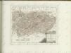

[Bar-le-Duc et environs]
1 : 20000 Annotatie: Herdruk van originele koperplaat; Oorspr. uitg.: ca. 1850 [Paris : I.G.N.]
Plan de Nancy
Nancy (Francie) Le Rouge, Georges-Louis Stanislav Le Rouge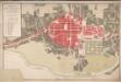
Nanci Ville Capitale De La Lorraine
Ludwig VIIII. (Hessen-Darmstadt, Landgraf)
Plan de Nancy
Nancy
1 : 6000 [S.l. : s.n.]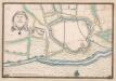
A colored plan of the fortifications of Toul
A colored manuscript plan of the fortifications of Toul in Lorraine, France; drawn about 1650, on a scale of 100 toises to an inch.
Plan general de Nancij / L. Finck
1 : 4000 Annotatie geografische gegevens: Met legenda: Table des renvoys [S.l. : s.n.]
Meßtischblatt 3589 : Erlen, 1917
1 : 250000 Erlen. - Aufn. 1880, hrsg. 1882, Aufldr. 1917. - 1:25000. - [Berlin]: Reichsamt für Landesaufnahme, 1917. - 1 Kt.
Meßtischblatt [7003] : Solgne, 1882
1 : 250000 Solgne. - Aufn. 1880. - 1:25000. - [Berlin]: Reichsamt für Landesaufnahme, 1882. - 1 Kt.
Civitas Leucorum sive Pagus Tullensis aujourdhui le diocese de Toul
1 : 300000 Delisle, Guillaume I. Covens et C. Mortier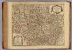
Civitas Leucorum, Diocese de Toul.
1 : 303000 L'Isle, Guillaume de, 1675-1726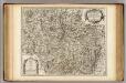
Civitas Leucorum, Diocese de Toul.
1 : 303000 L'Isle, Guillaume de, 1675-1726
[Atlas départemental : La France et ses colonies] No. 54 Meuse
1 : 670000 publ. par Michel fils ainé [dressé par A. Lorrain, et gravé par H. Dandeleux] Versailles [etc.] : Barreswil et Andrieux
Dept. De La Meuse.
1 : 579000 Levasseur, Victor.
Département de la Meuse
1 Karte : Kupferdruck ; 41 x 32 cm Capitaine s.n.
Departement de la Meuse
1 Karte : Kupferdruck ; 49 x 48 cm Houdan au bureau de l'atlas national rue de la Harpe no. 26, et au dépôt du dit atlas rue de la Monnoye no. 5