Maps of Somme

Carte de la Picardie
1 Karte : Kupferdruck ; 50 x 64 cm Vauchelle; Agnes chez Agnes
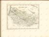
Partie meridionale de Picardie
1 Karte : Kupferdruck ; 47 x 61 cm L'Isle; Rousseville; Des Rosiers; Lesperon chez l'auteur sur le quai de l'Horloge
Partie meridionale de Picardie
1 Karte : Kupferdruck ; 47 x 61 cm L'Isle; Buache; Dezauche; Des Rosiers; Lesperon chez Dezauche successeur des S.rs Delisle et Buache rue des Noyers près celle des Anglois
Partie meridionale de Picardie
1 Karte : Kupferdruck ; 46 x 60 cm L'Isle chez J. Cóvens et C. Mortier geographes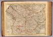
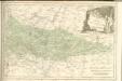
Picardie meridionale.
1 : 210000 L'Isle, Guillaume de, 1675-1726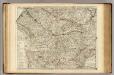
Picardie meridionale.
1 : 210000 L'Isle, Guillaume de, 1675-1726
Picardia
1 Karte : Kupferdruck ; 36 x 49 cm Janssonius apud Ioannem Ianssonium

Picardiae, Belgicæ regionis descriptio
1 Karte : Kupferdruck ; 32 x 50 cm Ortelius; Surhon; Surhon s.n.
Picardia
1 Karte : Kupferdruck ; 36 x 48 cm Mercator; Hondius Henricus Hondius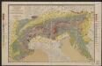
Picardia [Karte], in: Gerardi Mercatoris et I. Hondii Newer Atlas, oder, Grosses Weltbuch, Bd. 2, S. 29.
1 Karte aus Atlas Mercator, Gerhard und Hondius, Jodocus Jansson, Jan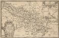
Picardiae, Belgicae regionis descriptio. [Karte], in: Theatrum orbis terrarum, S. 140.
1 Karte aus Atlas Ortelius, Abraham Vrients, Jan Baptista
Picardia
1 : 361000 Pikardie (Francie)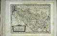
Picardia
1 Karte : Kupferdruck ; 17 x 24 cm Mercator; Keere Cloppenburgh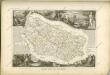

Partie Meridionale de Picardie
1 : 208000 Mollova mapová sbírka Delisle, Guillaume L'Isle, Guillaume de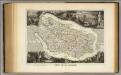
Dept. Des De La Somme.
1 : 378000 Levasseur, Victor.
Generalkarte von Zentraleuropa

Amiens 95, uit: [W. Liebenow's Special-Karte von Mittel-Europa]
1 : 300000 titelvariant: W. Liebenow's Mittel-Europa; Annotatie: Titel boven de bladen: W. Liebenow's Mittel-Europa Johannes Wilhelm Liebenow 1822-1897 Hannover : Hermann Oppermann
Ambiani
1 Karte : Kupferdruck ; 38 x 40 cm Sanson; Robert de Vaugondy; Cordier chez le Sr. Robert g. du r. quai de l'Horloge
Amiens 95, uit: Special-Karte von Mittel-Europa / nach amtlichen Quellen bearbeitet von W. Liebenow
1 : 300000 titelvariant: W. Liebenow's Mittel-Europa; Annotatie: Titel boven de bladen: W. Liebenow's Mittel-Europa Johannes Wilhelm Liebenow 1822-1897 Frankfurt a. M. : Ludwig Ravenstein
Département de la Somme
1 Karte : Kupferdruck ; 49 x 48 cm Houdan au bureau de l'Atlas nation.le de France rue de la Monnoye no. 5
Picardia
1 Karte : Kupferdruck ; 14 x 19 cm Lambert Andreae
Département de l'Oise
1 Karte : Kupferdruck ; 49 x 48 cm Houdan au bureau de l'atlas national de France rue Serpente no. 15 et au cabinet bibliographique rue de la Monnoye no. 5
Arras, Peronne, Noyon, uit: Le conflict mondial : front occidental
1 : 170000 Annotatie: Ontbreekt: no. 1 en 5-8 Gand : Th. de Graeve
Veromandui
1 Karte : Kupferdruck ; 34 x 38 cm Sanson; Robert de Vaugondy; Cordier chés le Sr. Robert geog. du r. quai de l'Horloge
[Amiens]
1 Blatt : 60 x 91 cm s.n.