Maps of Somme

Artesia comit
1 Karte : Kupferdruck ; 33 x 43 cm Mercator; Hondius Henricus Hondius
Artesia comit
1 Karte : Kupferdruck ; 33 x 43 cm Hondius; Mercator Jodocus Hondius
Artesia comit
1 Karte : Kupferdruck ; 33 x 43 cm Mercator s.n.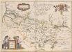
Picardia Regio Belgica [Karte], in: Theatrum orbis terrarum, sive, Atlas novus, Bd. 2, S. 32.
1 Karte aus Atlas Blaeu, Joan Blaeu, Willem Janszoon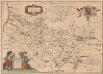
Picardia Regio Belgica [Karte], in: Novus Atlas, das ist, Weltbeschreibung, Bd. 2, S. 29.
1 Karte aus Atlas Blaeu, Joan Blaeu, Willem Janszoon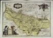
Picardia regio belgica
1 Karte : Kupferdruck ; 37 x 51 cm Blaeu; Blaeu; Surhon; Surhon apud Guiljelmum et Joannem Blaeu
Artesia Comit: [Karte], in: Gerardi Mercatoris Atlas, sive, Cosmographicae meditationes de fabrica mundi et fabricati figura, S. 308.
1 Karte aus Atlas Mercator, Gerhard Montanus, Petrus
Picardia Regio Belgica [Karte], in: Le théâtre du monde, ou, Nouvel atlas contenant les chartes et descriptions de tous les païs de la terre, Bd. 2, S. 29.
1 Karte aus Atlas Blaeu, Willem Janszoon und Blaeu, Joan Blaeu, Willem Janszoon
Carte du govvernement general de Picardie qui comprend la generalité d'Amiens avec l'Artois [et] les frontieres des Pays Bas
1 Karte : Kupferdruck ; 46 x 55 cm L'Isle les Heritiers de Homan
Gouvernement de Picardie
1 Karte : Kupferdruck ; 31 x 42 cm Mentelle; Tardieu; Dubuisson Mentelle
Carte du gouvernement general de Picardie qui comprend la generalité d'Amiens avec l'Artois & les frontieres des Pays Bas
1 : 400000 dressée sur le dessin des cartes de Mr. de l'Isle [Nürnberg] : publ. par les Heritiers de Homan
Artois Picardie
1 Karte : Kupferdruck ; 20 x 27 cm Crépy Crépy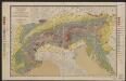
Picardia [Karte], in: Gerardi Mercatoris et I. Hondii Newer Atlas, oder, Grosses Weltbuch, Bd. 2, S. 29.
1 Karte aus Atlas Mercator, Gerhard und Hondius, Jodocus Jansson, Jan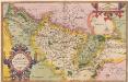
Picardiae, Belgicae regionis descriptio. [Karte], in: Theatrum orbis terrarum, S. 83.
1 Karte aus Atlas Ortelius, Abraham

Carte generale de Picardie
1 Karte : Kupferdruck ; 25 x 35 cm Merian Caspar Merian
Picardia
1 Karte : Kupferdruck ; 36 x 48 cm Mercator; Hondius Henricus Hondius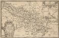
Picardiae, Belgicae regionis descriptio. [Karte], in: Theatrum orbis terrarum, S. 140.
1 Karte aus Atlas Ortelius, Abraham Vrients, Jan Baptista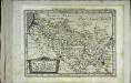
Picardia
1 Karte : Kupferdruck ; 17 x 24 cm Mercator; Keere Cloppenburgh
Picardia
1 : 361000 Pikardie (Francie)
Comté d'Artois Basse Picardie et Grande Partie dela Haute Picardie qui composent le Gouvernement General de Picardie avec le Cambresis partie des Comtez de Flandre et d'Haynaut Generalité d'Amiens
1 : 290000 Mollova mapová sbírka Nolin, Jean-Baptiste Nolin, Jean Baptiste II.
Picardia
1 Karte : Kupferdruck ; 36 x 49 cm Janssonius apud Ioannem Ianssonium
Sheet 8, uit: Stanford's large scale map of the seat of war / Stanford's Geographical Estab[lishmen]t
1 : 300000 Stanford's Geographical Establishment, Londen London : Stanford
Picardiae, Belgicæ regionis descriptio
1 Karte : Kupferdruck ; 32 x 50 cm Ortelius; Surhon; Surhon s.n.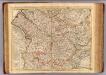
Picardie meridionale.
1 : 210000 L'Isle, Guillaume de, 1675-1726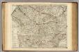
Picardie meridionale.
1 : 210000 L'Isle, Guillaume de, 1675-1726
Artesia, Comitatus. Artois. [Karte], in: Novus Atlas, das ist, Weltbeschreibung, Bd. 1, S. 351.
1 Karte aus Atlas Blaeu, Joan Blaeu, Willem Janszoon
Artesia, Comitatus. Artois. [Karte], in: Theatrum orbis terrarum, sive, Atlas novus, Bd. 1, S. 391.
1 Karte aus Atlas Blaeu, Joan Blaeu, Willem Janszoon
Geographica Artesiae Comitatus Tabula [Karte], in: Novus atlas absolutissimus, Bd. 3, S. 141.
1 Karte aus Atlas Janssonius Offizin


