Maps of Indre

Département de l'Indre
1 Karte : Kupferdruck ; 34 x 41 cm Capitaine s.n.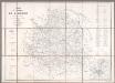
Carte du Département de l'Indre / Ad. Appé et E. Robin del.
1 : 200000 Appé, Ad.; Robin, E. Châteauroux : Nuret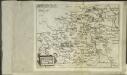
Bitvrigvs
1 Karte : Kupferdruck ; 15 x 19 cm Lambert Andreae
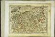
Département de l'Indre
1 Karte : Kupferdruck ; 48 x 48 cm Houdan; Dumez chez Dumez d.teur de l'atlas national de France rue de la Harpe n.o 26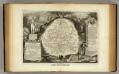
Dept. De L'Indre.
1 : 580000 Levasseur, Victor.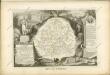
Biturigum ducatus
1 Karte : Kupferdruck ; 17 x 24 cm Mercator; Keere Cloppenburgh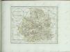
[Le Blanc - Châteauroux - Montmorillon]
1 Blatt : 60 x 92 cm s.n.
[Loches]
1 Blatt : 60 x 91 cm s.n.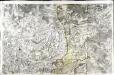
[La Châtre]
1 Blatt : 60 x 91 cm s.n.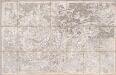
No. 11 [Indre], uit: Carte géométrique de la France dite "Carte de Cassini" ou "de l'Académie"
1 : 86400 titelvariant: Carte de Cassini; Annotatie: Incompleet; Voor aanwezige bladen zie overzichtsblad Cassini de Thury, C.-F. Paris : [s.n.]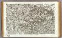
31 Le Blanc, Chateauroux, Montmorillon.
1 : 86400 Cassini family; Cassini, Cesar-Francois, 1714-1784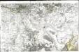
[Bourges]
1 Blatt : 60 x 91 cm Le Roy s.n.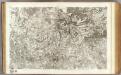
11 La Chatre.
1 : 86400 Cassini family; Cassini, Cesar-Francois, 1714-1784
Govvernement de Bourges
1 Karte : Kupferdruck ; 11 x 15 cm Sebastian Cramoisy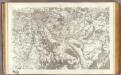
10 Bourges.
1 : 86400 Cassini family; Cassini, Cesar-Francois, 1714-1784
30 Loches.
1 : 86400 Cassini family; Cassini, Cesar-Francois, 1714-1784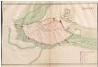
Bourges
A colored manuscript plan of the fortifications of the town of Bourges, France; drawn about 1650.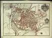
Plan de la ville et des fauxbourgs de Bourges capitale de la province de Berri
1 Plan : Kupferdruck ; 23 x 33 cm Fer Nicolas de Fer
Gouvernement de Berry
1 Karte : Kupferdruck ; 31 x 41 cm Mentelle; Tardieu; Dubuisson Mentelle
Bitvricvm dvcatvs
1 Karte : Kupferdruck ; 35 x 46 cm Valck; Schenk apud Gerardum Valk et Petrum Schenk
Berry ducatus
1 Karte : Kupferdruck ; 32 x 41 cm Mercator; Hondius Henricus Hondius
Berry ducatus
1 Karte : Kupferdruck ; 32 x 41 cm Hondius; Mercator Jodocus Hondius
Berry ducatus
1 Karte : Kupferdruck ; 32 x 40 cm Mercator s.n.
Biturigum
1 Karte : Kupferdruck ; 35 x 47 cm Mercator; Hondius; Hondius; Tavernier imprimé ches Iosse Hondius, se vendent ches Melchior Tavernier aupres du Palais
Bitvricvm dvcatvs
1 Karte : Kupferdruck ; 37 x 48 cm Blaeu; Blaeu Guiljelmus Blaeuw excudit

Biturigum Le Duche de Berry [Karte], in: Gerardi Mercatoris et I. Hondii Newer Atlas, oder, Grosses Weltbuch, Bd. 2, S. 86.
1 Karte aus Atlas Mercator, Gerhard und Hondius, Jodocus Jansson, Jan


