Maps of Loiret

Département du Loiret
1 Karte : Kupferdruck ; 49 x 48 cm Houdan au bureau de l'atlas national de France rue Serpente n.o 15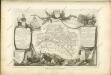
Dept. Du Loiret.
1 : 571000 Levasseur, Victor.
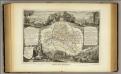
Département du Loiret
1 Karte : Kupferdruck ; 33 x 41 cm Capitaine s.n.
[Atlas départemental : La France et ses colonies] No. 44 Loiret
1 : 670000 publ. par Michel fils ainé [dressé par A. Lorrain, et gravé par H. Dandeleux] Versailles [etc.] : Barreswil et Andrieux
Département du Loiret
1 : 265000 Loiret (Francie) Houdan, François d' P. G. Chanlaire et Dumez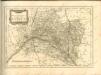

Diœcese de l'evesché d'Orleans
1 Karte : Kupferdruck ; 41 x 52 cm Sanson; Robert de Vaugondy; Somer chés le Sr. Robert geog. ord.re du roy quai de l'Horloge du Palais
Diœcese de l'evesché d'Orleans
1 Karte : Kupferdruck ; 41 x 52 cm Sanson; Mariette; Somer chez Pierre Mariette rue S. Iacques a l'Esperance
La generalité de Paris, 3
1 Blatt : 68 x 52 cm chez l'auteur
Orléans 137, uit: Special-Karte von Mittel-Europa / nach amtlichen Quellen bearbeitet von W. Liebenow
1 : 300000 titelvariant: W. Liebenow's Mittel-Europa; Annotatie: Titel boven de bladen: W. Liebenow's Mittel-Europa Johannes Wilhelm Liebenow 1822-1897 Frankfurt a. M. : Ludwig Ravenstein
Orléans 137, uit: [W. Liebenow's Special-Karte von Mittel-Europa]
1 : 300000 titelvariant: W. Liebenow's Mittel-Europa; Annotatie: Titel boven de bladen: W. Liebenow's Mittel-Europa Johannes Wilhelm Liebenow 1822-1897 Hannover : Hermann Oppermann
Gastinois et Senonois
1 : 340000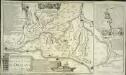
Les jonctions des deux grandes rivieres de Loire et de Seine par le nouveau canal d'Orleans et celuy de Briare
1 Karte : Kupferdruck ; 38 x 49 cm, Bildgrösse 38 x 64 cm Fer; Danet; Inselin se vend chez Danet gendre de l'auteur sur le pont N. Dame a la Sphere royale
Les jonctions des deux grandes riveres de Loire et de Seine par le Nouveau canal d'Orleans et celuy de Briare
1 : 169000 Briare (Francie) Fer, Nicolas de Inselin, Charles de Fer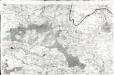
[Orléans]
1 Blatt : 60 x 91 cm s.n.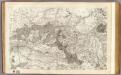
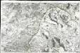
8 Orleans.
1 : 86400 Cassini family; Cassini, Cesar-Francois, 1714-1784
Partie septentrionale de l'evesché de Chartres
1 Karte : Kupferdruck ; 45 x 60 cm Sanson; Jaillot H. Iaillot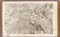
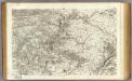
9 Gien.
1 : 86400 Cassini family; Cassini, Cesar-Francois, 1714-1784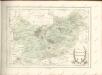
[Gien]
1 Blatt : 60 x 91 cm Le Roy s.n.
Govvernement de St. Mathurin de l'Arquan
1 Karte : Kupferdruck ; 11 x 15 cm Sebastian Cramoisy
Govverneme[n]t d'Orleans
1 Karte : Kupferdruck ; 11 x 15 cm Sebastian Cramoisy
Govverneme[n]t de Montargis
1 Karte : Kupferdruck ; 11 x 15 cm Sebastian Cramoisy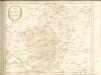
28 Vendome.
1 : 86400 Cassini family; Cassini, Cesar-Francois, 1714-1784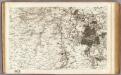
7 Fontainebleau, Etampes.
1 : 86400 Cassini family; Cassini, Cesar-Francois, 1714-1784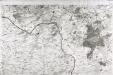
[Fontainebleau - Etampes]
1 Blatt : 60 x 91 cm s.n.
Gowerneme[n]t de Chau=Regnard
1 Karte : Kupferdruck ; 11 x 15 cm Sebastian Cramoisy


