Maps of Mortagne-au-Perche
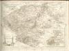
Partie superieure orientale de l'evesché du Mans
1 Blatt : Jaillot
[Alençon]
1 Blatt : 60 x 91 cm s.n.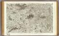
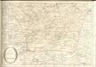
63 Alencon.
1 : 86400 Cassini family; Cassini, Cesar-Francois, 1714-1784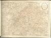
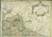
Perchensis comitatus
1 Karte : Kupferdruck ; 17 x 25 cm Mercator Cloppenburgh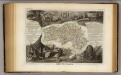
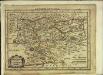
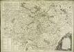
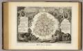
Dept. De L'Orne.
1 : 563000 Levasseur, Victor.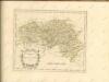
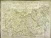
Carte du gouvernement général du Maine et Perche
1 Karte : Kupferdruck ; 47 x 67 cm Basset; Haussard; Delafosse; Basset chéz Basset rue St. Jacques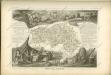
Carte des provinces du Maine et du Perche
1 Karte : Kupferdruck ; 45 x 63 cm L'Isle; Buache chez l'auteur sur le quai de l'Horloge
Le diocese de Sees
1 Karte : Kupferdruck ; 59 x 49 cm Jaillot; La Salle; Jenvilliers chez le Sr. Iaillot joignant les grands Augustins aux deux globes
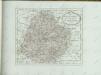
Département de l'Orne
1 Karte : Kupferdruck ; 48 x 52 cm Houdan au bureau de l'atlas national de France rue Serpente n.o 15, et au cabinet bibliographique rue de la Monnoye n.o 5
CENAMANORVM | Galliæ regionis typus: | Vulgo | LE MANS.
Auct. Matheo Ogerio. Apud Guiljemum Blaeu.
Cenomanorvm Galliæ regionis typus vulgo le Mans
1 Karte : Kupferdruck ; 37 x 48 cm Blaeu; Oger apud Guiljemum Blaeu
Perchensis Comitatus La Perche Comte [Karte], in: Novus atlas absolutissimus, Bd. 4, S. 118.
1 Karte aus Atlas Janssonius Offizin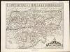
Carte du Grand Perche et Perche Gouet
1 : 285000
Perchensis Comitatus La Perche Comté [Karte], in: Novus Atlas, das ist, Weltbeschreibung, Bd. 2, S. 106.
1 Karte aus Atlas Blaeu, Joan Blaeu, Willem Janszoon
Perchensis Comitatus La Perche Comté [Karte], in: Le théâtre du monde, ou, Nouvel atlas contenant les chartes et descriptions de tous les païs de la terre, Bd. 2, S. 104.
1 Karte aus Atlas Blaeu, Willem Janszoon und Blaeu, Joan Blaeu, Willem Janszoon
Perchensis Comitatus La Perche Comté [Karte], in: Theatrum orbis terrarum, sive, Atlas novus, Bd. 2, S. 70.
1 Karte aus Atlas Blaeu, Joan Blaeu, Willem Janszoon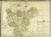
Direction du Mans
1 Karte : Kupferdruck ; 46 x 65 cm Nolin; Jenvilliers chez l'auteur rue St. Jacques au dessus de la rue des Mathurins à l'ens.gne de la place des Victoires
Perchensis comitatvs
2 Karten auf 1 Blatt : Kupferdruck ; Bildgrösse 39 x 50 cm Janssonius; Du Temps Joannes Janssonius
Perchensis comitatvs
2 Karten auf 1 Blatt : Kupferdruck ; Bildgrösse 39 x 50 cm Blaeu; Du Temps apud Guiljelmum Blaeuw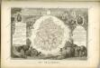
Dept. De La Sarthe.
1 : 556000 Levasseur, Victor.
Bitvricvm dvcatvs
1 Karte : Kupferdruck ; 27 x 35 cm Janssonius Joannes Janssonius
Département de la Sarte
1 Karte : Kupferdruck ; 49 x 48 cm Houdan s.n.
[Chartres]
1 Blatt : 60 x 91 cm Brunet; Desbruslins s.n.