Maps of Côtes-d'Armor

Carte de France, 1
2 Blätter : Kupferdruck ; 53 x 45 cm Crepy
Wester Deel van 't Canaal [Karte], in: De Nieuwe Groote Vermeerderde Zee-Atlas ofte Water-Werelt, S. 45.
1 Karte aus Atlas Doncker, Hendrick
7) IV.N.O. ''Morlaix'', uit: Carte géologique de France
1 : 500000 Annotatie: Voor aanwezige bladen zie bladoverzicht [S.l : s.n.]
Carte reduite des isles de Jersey, Grenesey et d'Aurigny
1 Karte : Kupferdruck ; 54 x 40 cm Bellin s.n.
Carte de la France, no. 3
1 Blatt : 59 x 41 cm s.n.
England
1 : 778000 under the superintendence of the Society for the Diffusion of Useful Knowledge J. & C. Walker sculpt. London : Baldwin and Cradock
delineation of the strata of England and Wales, with part of Scotland
1 : 320000 Blatt 13 Smith, William Cary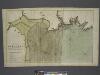
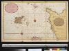
The coast of BRETAGNE from GRANVILLE to CAPEFREHEL
from The sea-atlas : containing an hydrographical description of most of the sea-coasts of the known parts of the world.
1) I.O. ''Plymouth'', uit: Carte géologique de France
1 : 500000 Annotatie: Voor aanwezige bladen zie bladoverzicht [S.l : s.n.]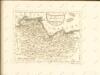
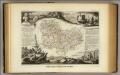
Dept. De Cotes du Nord.
1 : 571000 Levasseur, Victor.
Carte géométrique de la province de Bretagne, 1
1 Blatt : chés l'auteur
Jersey, Guernsey.
1 : 364000 Faden, William, 1750?-1836
Een gedeelte vant Kanaal van Kingsbudg tot Big Berrij
England Gerard van Keulen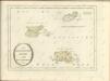
Sheets 3-4. (Cary's England, Wales, and Scotland).
1 : 360000 Cary, John, ca. 1754-1835
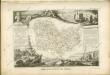
Département des Côtes du Nord
1 Karte : Kupferdruck ; 48 x 49 cm Houdan; Dumez chez Dumez directeur de l'atlas national rue de la Harpe n.o 26, et au dépôt de cet atlas placé au cabinet bibliographique rue de la Monnoye n.o 5
Devonia Vulgo Devon-Shire. [Karte], in: Theatrum orbis terrarum, sive, Atlas novus, Bd. 4, S. 136.
1 Karte aus Atlas Blaeu, Joan Blaeu, Willem Janszoon
Devonia Vulgo Devon-Shire. [Karte], in: Theatrum orbis terrarum, sive, Atlas novus, Bd. 4, S. 136.
1 Karte aus Atlas Blaeu, Joan Blaeu, Willem Janszoon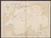
Devonia vulgo Devon-Shire. [Karte], in: Le théâtre du monde, ou, Nouvel atlas contenant les chartes et descriptions de tous les païs de la terre, Bd. 4, S. 120.
1 Karte aus Atlas Blaeu, Willem Janszoon und Blaeu, Joan Blaeu, Willem Janszoon
Carte générale, des isles Grenesey, Jersey, Aurigny, Chausey, &c
1 Karte : Kupferdruck ; 50 x 43 cm Beaurain chez le chevalier de Beaurain rue Git-le cœur la 1.ere porte en entrant par le quai des Augustins
Diocese de Coutances, [feuille 1 et 3]
2 Blätter : Dezauche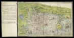
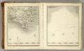
Ottermouth Haven [Coasts of Devon and Dorset from Dartmouth to Weymouth with a written description of Ottermouth Haven]
This is a map of the coast of Devon and Cornwall from Dartmouth to Weymouth which forms part of an atlas that belonged to William Cecil Lord Burghley, Secretary of State to Elizabeth I. Burghley used this atlas to illustrate domestic matters. This map shows the coastline in a pictorial fashion, with buildings indicated by generic, rather than individualized images of various building types. In the left hand margin is a written description of Ottermouth haven, which also features on the map itself. A dominating feature of the map in the compass rose in the centre which has lines radiating from it, each with a direction written along side it. From the style of the lettering and the depiction of the ships the map can be dated to the around 1540. Lord Burghley has annotated the map, adding a we’y of xviii foot brod’ to a narrow bridge of land and adding Sandfoot castle to the coastline to the right of the Isle Portland. The map may have originally been drawn in connection with the 1539-40 invasion scare caused by the alliance against England of France and Spain. The fortification of the Dorset coast was an essential part of the defensive preparations and in April 1539 Lord Russell surveyed the area, sending a plat’ to Cromwell which suggested a much more ambitious fortification program than was actually carried out. Sandfoot, which Lord Burghley has inserted onto this map, was in commission by 1541-1542. The fact that it does not originally appear on the map suggests that it was not built at the time of the maps execution. This is curious however as Portland Castle, built at the same time as Sandfoot, was included by the original draughtsman. The castles were intended to be able to cross fire over the important anchorage known as Portland Roads. Lord Burghley’s interest in the area can be attributed to a new invasion threat from Spain. This threat was also rooted in religious ideology as the Catholic Philip II of Spain wanted to remove the ardently Protestant Elizabeth I from the English Throne. Unfortunately, the coastal forts in Dorset, as with others in England, had been allowed to fall into disrepair. Finally in 1584 action to repair the Dorset forts was authorised by the Privy Council. William Cecil, Lord Burghley
Devoniae Descriptio. The Description of Devon-Shire [Karte], in: Novus atlas absolutissimus, Bd. 7, S. 199.
1 Karte aus Atlas Janssonius Offizin
DEVONIA | vulgo | DEVON-SHIRE.
[Amsterdam : Joan Blaeu]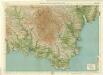
South Devon, Sheet 36 - Bartholomew's "Half Inch to the Mile Maps" of England & Wales
1 : 126720 Topographic maps Bartholomew, John George John Bartholomew & Co
delineation of the strata of England and Wales, with part of Scotland
1 : 320000 Blatt 12 Smith, William Cary
Carte des isles Jersey Grenesey Aurigny et Cers
1 Karte auf 2 Blättern : Kupferdruck ; 67 x 89 cm Lattré chez Lattré graveur ordinaire du roi de M. le Duc d'Orléans et de la ville rue St. Jacques la porte cochere vis-à-vis celle de la parcheminerie à la ville de Bordeaux