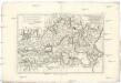
Maps of Ávila

Mapa de la provincia de Avila
1 Karte : Kupferdruck ; 37 x 37 cm López s.n.
Segoviæ et Avilæ provinciarum charta geographica
1 Karte : Kupferdruck ; 43 x 55 cm López; Güssefeld; Vogel in lucem edita per Hom. Hered
Invictissimo principi Phillipo V. Hispaniarum regi la Castille vieille et nouvelle avec l'Estremadure divisé en Estremadure de Castille et de Leon
1 : 1090000 Extremadura (Španělsko) Nolin, Jean-Baptiste Mendes Silva, Rodrigo I.B. Nolin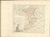

Mapa de la provincia de Segovia
1 Karte auf 4 Blatt : Kupferdruck ; 71 x 78 cm López s.n.
Charta provinciam Salamanticam hispanice Salamanca, exhibens
1 Karte : Kupferdruck ; 44 x 53 cm Güssefeld; López in lucem edita per Homann. Hæredes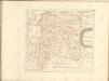

Madrid
1 : 200000 Coello, Francisco [Verlag nicht ermittelbar]
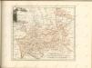
Mapa de la provincia de Toledo
1 Karte : Kupferdruck ; 37 x 40 cm López s.n.
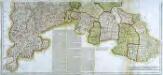
Mapa geografica de la provincia de Salamanca, en que se distinguen sus partidos ... / por Tomas Lopez
1 : 200000 Annotatie: Met opdracht aan Joseph Alvarez de Toledo; Met toelichting op de kaart Lopez, Tomas Madrid : [Tomas Lopez]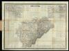
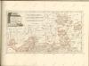
Segovia
1 : 200000 Coello, Francisco ; Madoz, Pascual [Imprenta del Atlas de España]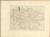
Mapa geografico de la provincia de Salamanca, 1
2 Blätter : 43 x 90 cm s.n.
Mapa geografico del partido de Toro / por Tomas Lopez
1 : 250000 Annotatie: Met toelichting op de kaart Lopez, Tomas Madrid : demas obras de su autor, y las de su hijo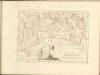
Mapa geografico de la provincia de Salamanca, 2
2 Blätter : 42 x 91 cm s.n.
Mapa geográfico del partido de Toro
1 Karte : Kupferdruck ; 34 x 37 cm López s.n.
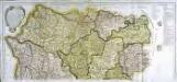
Il regno di Leone
1 Karte : Kupferdruck ; 55 x 41 cm Cantelli da Vignola; Rossi; Barbey dato in luce da Dom.co de Rossi erede di Gio. Giac.o de Rossi dalle sue stampe
[Carte d'Espagne et de Portugal en neuf feuilles, 5]
1 Blatt : 31 x 41 cm P.G. Chanlaire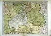
Espagne et Portugal, 5
1 Blatt : 31 x 42 cm Mentelle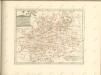

Castiliæ novæ pars occidentalis provincias Madrit, Toledo et Mancha comprehendens
1 Karte : Kupferdruck ; 48 x 46 cm Güssefeld; López apud Homannianos Heredes
A map of old & new Castile
1 : 1100000 Kastilie (Španělsko) Mendes Silva, Rodrigo Ioh. Senex
Castilla la Nueva con las nuevas divisiones
1 Mapa. Atlas Nacional de España Dufour, A.H. 0
Estremadura con las nuevas divisiones
1 Mapa. Atlas Nacional de España. Dufour, A.H. 0

Castilla la Vieja con las nuevas divisiones
1 Mapa. Atlas Nacional de España Dufour, A.H. 0