Maps of Soria
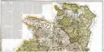
Mapa geográfico de la provincia de Soria, 1
2 Blätter : s.n.
Mapa de la Rioja
1 Karte : Kupferdruck ; 35 x 40 cm López s.n.
Mapa geografico que comprehende el partido de Santo Domingo de la Calzada y el de Logroño, correspondientes a la provincia de Burgos
1 Karte : Kupferdruck ; 36 x 39 cm López s.n.
Logroño
1 mapa. Datat entre 1901 i 1903 aproximadament. 0 Ed. Martin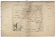
Des Königreichs Navarra südwestlicher Theil
1 : 240000 Navarra (Španělsko)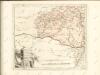

Mapa geográfico del nuevo obispado de Tudela
1 Karte : Kupferdruck ; 25 x 37 cm, Bildgrösse 36 x 39 cm López s.n.
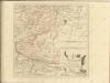
Charta geographica provinciam Soriam
1 Karte : Kupferdruck ; 43 x 57 cm López; Güssefeld Homanniani Haeredes ederunt
Logroño
1 : 200000 1 Mapa, b/n. Dins: Atlas de España y sus posesiones de ultramar Coello, Francisco ; Madoz, Pascual Imprenta del Atlas de España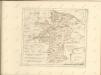

Logroño
1 : 200000 Coello, Francisco [Verlag nicht ermittelbar]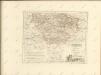

Mapa de Navarra
1 : 200000 1 mapa entelat. 0 0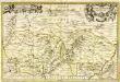
Tarraconensis episcopatus
1 Karte : Kupferdruck ; 32 x 50 cm Valck; Schenk apud G. Valk et P. Schenk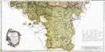
Mapa geográfico de la provincia de Soria, 2
2 Blätter : s.n.
44) XIII.N.E. ''Navarre'', uit: Carte géologique de France
1 : 500000 Annotatie: Voor aanwezige bladen zie bladoverzicht [S.l : s.n.]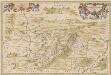
Tarraconensis Episcopatus. [Karte], in: Novus atlas absolutissimus, Bd. 6, S. 55.
1 Karte aus Atlas Janssonius Offizin
EPISCOPATUS | TURIASSONENSIS | Vulgo | TARRAÇONA
Auctore Joanne Baptista Labanna. [Amsterdam : Joan Blaeu]

Mapa del m. n. y m. l. provincia de Alava
1 Karte : Kupferdruck ; 37 x 37 cm López s.n.
Il regno di Castiglia vecchia
1 Karte : Kupferdruck ; 42 x 54 cm Cantelli da Vignola; Rossi; Barbey Domenico de Rossi
Legionis, Biscaiae et Guipiscoae typus
1 Karte : Kupferdruck ; 17 x 24 cm Mercator Cloppenburgh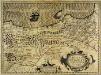
Legionis, Biscaiæ et Guipiscoæ typus
1 Karte : Kupferdruck ; 33 x 46 cm Mercator; Hondius Jodocus Hondius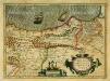
Legionis, Biscaiæ et Guipiscoæ typus
1 Karte : Kupferdruck ; 33 x 46 cm Mercator; Hondius Henricus Hondius
[Carte d'Espagne et de Portugal en neuf feuilles, 2]
1 Blatt : 31 x 41 cm P.G. Chanlaire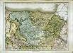
Espagne et Portugal, 2
1 Blatt : 31 x 42 cm Mentelle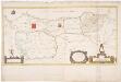
Principato Asturias, Biscaia et Guispus, Alava / [J.F. van Essen]
1 : 700000 Annotatie: De kaart is vermoedelijk vervaardigd door J.F. van Essen uit Antwerpen; Gerestaureerd, 1995; Met opgeplakte cartouches Essen, J. F. van [S.l. : s.n.]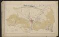
Legionis Biscaiae Et Guipiscoae Typus [Karte], in: Gerardi Mercatoris et I. Hondii Newer Atlas, oder, Grosses Weltbuch, Bd. 2, S. 183.
1 Karte aus Atlas Mercator, Gerhard und Hondius, Jodocus Jansson, Jan


